 |
Cleveland Circle Southwest, 1941
Looking westerly at the rear of houses on Reservoir Rd.
[Source: Digital Commonwealth]
|
 |
Cleveland Circle Southwest, 1941
Looking northwest. Looking left to right from mid photo:
- Indistinct views of the rears of 285 and 295 Reservoir Rd.
- 57 Reservoir Lane
- 325 Reservoir Rd. (Newton), the white house next to the pumping station
- 2442 Beacon St., the rear of the pumping station
[Source: Digital Commonwealth]
|
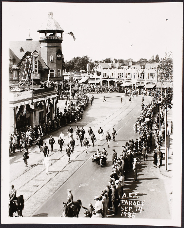 |
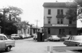
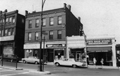
Parade, Coolidge Corner, September 14, 1935
Looking north on Harvard St. Some 15,000 veterans of the 101st Infantry American Expeditionary Forces held their annual reunion in Brookline and this is their parade. The route started at Harvard and Stedman Streets and proceeded south on Harvard Street to the Village Square, west on the Worcester Turnpike to Cypress Street, south on Cypress to High St. ending at the Brookline Field on Jamaica Rd. and Pond Ave.
Viewed on the western side of Harvard St. from left to right:
- The T. C. Baker Ford dealership at 1331 Beacon St.
- S. S. Pierce and Co. on the northwest corner of Beacon and Harvard streets.
Viewed on the eastern side of Harvard St. from left to right:
- 289 Harvard St. The awning of Gurleys Bakery
- Green St.
- 285-287 Harvard St. The Edison Shop, sellers of home appliances.
- 283a Harvard St. The Fanny Farmer Candy Shop
- 283 Harvard St. The Faneuil Hall Fruit Store
- 281a Harvard St. Carrolls Cut-Rate Perfumer
- 279 Harvard St. The First National Stores, groceries
- 275 Harvard St. Brookline Savings Bank
- 273 Harvard St. Frank W. Savage, real estate
- 271 Harvard St. The Dorothy Muriel Shop, deli and liquors
- 269 Harvard St. Entrance to the upstairs offices
- 267 Harvard St. Alice Merrill, florist (beneath the Red Cab office)
[Source: Digital Commonwealth]
|
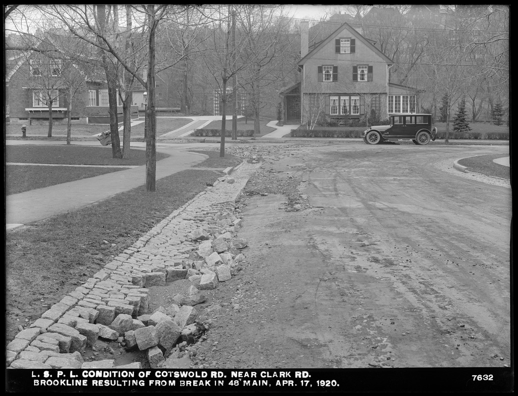 |
Clark Rd., Apr. 17, 1920
Looking northeast from Cotswold Rd. 301 Clark Rd. is on the left, #295 on the right, both still standing.
[Source: Digital Commonwealth]
|
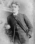 |
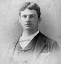
Moses Williams Jr., 1884
1869 1941. He was a son of prominent Brookline citizens Moses Williams and Martha C. Finnley. They lived on the southeast corner of Warren St. (then a part of Walnut St.) and Boylston St. He was a lawyer and married Anne Henrietta Nancy Whiteside in 1905.
From a photo album of Mary Eleanor ("Mamie") Williams.
|
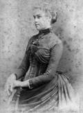 |
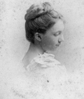
Mary Eleanor ("Mamie") Williams, 1896
1870 1964. She was a daughter of prominent Brookline citizens Moses Williams and Martha C. Finnley. They lived on the southeast corner of Warren St. (then a part of Walnut St.) and Boylston St.
She was interested in womens education, was an active supporter of Simmons College for many decades, and never married. Photographed in Dresden, Germany, March 1896.
From a photo album of Mary Eleanor ("Mamie") Williams.
|
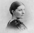 |
Julia Hayden (Lula) Richardson
1867 1965. She was a daughter of famed architect Henry Hobson Richardson and Julia Gorham Hayden. In 1886, she married George Foster Shepley an architect who worked in her fathers firm and later became a partner in the prominent firm of Shepley, Rutan, and Coolidge. They lived on Warren St.
From a photo album of Mary Eleanor ("Mamie") Williams.
|
 |
Mary Cornelia (Schlesinger) Perrin, 1895
18681943. Mary Cornelia Schlesinger was the second of five daughters of Barthold Schlesinger and Mary McBurney. The family lived in the massive mansion called Southwood that still stands at 278 Warren St. where it is now the site of the Holy Transfiguration Monastery. She married Arthur Perrin in 1894 and they lived at 132 Fisher Ave. and had two sons.
From a photo album of Mary Eleanor ("Mamie") Williams.
|
 |
William Atkinson, June 1896
1866 - 1934; married, 1900, to Mittie Harmon Jackson; parents: Edward Atkinson and Mary Caroline Heath; lived on Heath St. He was an architect, attended Harvard College, and was a graduate of M.I.T. His father was president of the Fire Insurance Co., the inventor of the Aladdin oven, a prolific author of tracts about economics, and a prominent businessman in Boston. His mother was a direct descendant of General William Heath, a right-hand man of George Washington during the Revolution.
From a photo album of Mary Eleanor ("Mamie") Williams.
|
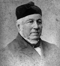 |
Moses Williams, Sr. (1846-1919)
He was a lawyer, president of State Street Trust Company, a state legislator, and involved in many aspects of the town affairs of Brookline. The family lived on the southeast corner of Warren St. (then a part of Walnut St.) and Boylston St.
From a photo album of Mary Eleanor ("Mamie") Williams.
|
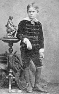 |
Hugh Williams (1872 - 1945)
He was a son of prominent Brookline citizens Moses Williams and Martha C. Finnley. They lived on the southeast corner of Warren St. (then a part of Walnut St.) and Boylston St. He became a surgeon at Mass General Hospital, lived in Boston, and never married.
From a photo album of Mary Eleanor ("Mamie") Williams.
|
 |
Dora Labouisse (1869-1952)
She grew up in New Orleans and had relatives, as yet unidentified, in Brookline. In 1889, she was visited by a daughter of Henry Hobson Richardson, who grew up in the area, and a daughter of Edward Atkinson. She often summered in Brookline in the ensuing decade before her marriage. In 1899, she married Philip Richardson, a son of famed architect Henry Hobson Richardson and Julia Gorham Hayden.
From a photo album of Mary Eleanor ("Mamie") Williams.
|
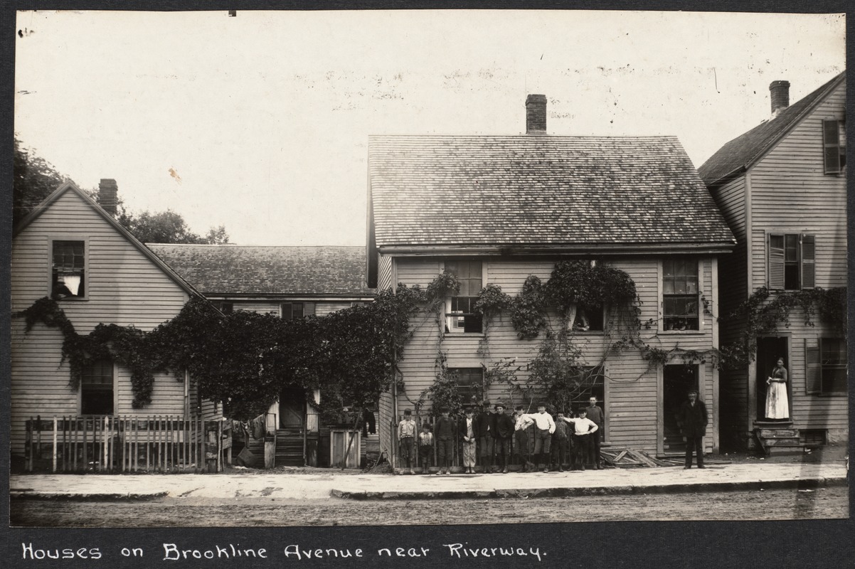 |
81-89 Brookline Ave.
From left to right are numbers 89, 87 (rear), 85, 81. There was a newspaper reference in 1909 to a nuisance problem at these addresses and they were torn down circa 1910.
[Source: Digital Commonwealth]
|
 |
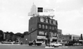
65 Kent St., Rear, January 1966
This substantial brick building was torn down in 1974 as the Marsh Urban Renewal Project was entering its core phase. Its removal accommodated the addition of a few additional feet for the covered parking platform straddling the tracks that remains today.
In the distance o the right is 74 Kent St. The large smoke stack of Brannens Laundry had been there for 75 years and was even considered to be an historic landmark of sorts when it had to be torn down in 1980.
From a notebook of property-appraisal photos taken in 1965 and early 1966 for The Marsh Urban Renewal Project run by the Brookline Redevelopment Authority. Only a few scattered peripheral structures remain today.
|
 |
100 Pearl St. (Former - Street Section Removed)
Looking northeast, the Robert Winthrop School building is just to the right. This building adjoined the pipe yard of the Brookline Water Dept. A liquidation sale of its contents was held in June 1974 and the building was razed by the Brookline Redevelopment Authority.
From a notebook of property-appraisal photos taken in 1965 and early 1966 for The Marsh Urban Renewal Project run by the Brookline Redevelopment Authority. Only a few scattered peripheral structures remain today.
|
 |
Gillis Builidng and Painting Co., 89 Pearl St., January 1966
Looking southwest toward Brookline Ave. On the immediate left, 97 Pearl St. has already been razed. A corner of the gas station at the corner of Brookline Ave. and Pearl St. can be glimpsed.
William Gillis was vice president of the Marsh Development Association which sought to privately redevelop the area of The Marsh as a counterpoint to the intention of the Brookline Redevelopment Authority to completely raze and rebuild the entire area.
From a notebook of property-appraisal photos taken in 1965 and early 1966 for The Marsh Urban Renewal Project run by the Brookline Redevelopment Authority. Only a few scattered peripheral structures remain today.
|
 |
84 Pearl St., August 1965
Looking south toward Lower Washington St. From right to left:
- Village Garage, car repair, 11 Pearl St.
- 1-5 Pearl St. at the rear of Brookline Auto Parts
- Brookline Print 10-14 Pearl St.
From a notebook of property-appraisal photos taken in 1965 and early 1966 for The Marsh Urban Renewal Project run by the Brookline Redevelopment Authority. Only a few scattered peripheral structures remain today.
|
 |
157-171 Washington St., July 1965
Looking at the north side of Lower Washington St. where the roadway becomes Boylston St. and Washington St. curves northward to the left in the photo. In one year, the Brookline Redevelopment Authority would begin the process of eminent domain to demolish all these buildings for the Hearthstone Plaza, the first phase of The Marsh Urban Renewal Project. From right to left:
- Jims Shoe Store, 157 Washington St. In the Village for three decades, the shop moved here in 1941 from its location at 139 Washington St.
- Village Barber Shop, 159 Washington St.
- Kenmore Valet, dry cleaning, 165 Washington St. They relocated to 39 Harvard St.
- Brookline Bulk Candy Co, 167 Washington St. They relocated to 216 Washington St. as Village Candies
- Ames Supply Co., 171 Washington St., (partial view) was one of thirteen businesses, out of 49 total in The Marsh, deemed not essential to village life and therefore not eligible for relocation by the Brookline Redevelopment Authority
From a notebook of property-appraisal photos taken in 1965 and early 1966 for The Marsh Urban Renewal Project run by the Brookline Redevelopment Authority. Only a few scattered peripheral structures remain today.
|
 |
127-131 Washington St., August 1965
Looking at the north side of Lower Washington St. prior to the start of the urban renewal project for the area known as The Marsh. In the center is the building at 127-131 Washington St. housing Sagamore Liquors on the left and The Village restaurant on the right. The large open space on the left had been the site of a wooden building from the 1800s known as Russell Block. In August 1962 the town ordered that it be demolished due to its dilapidated condition and no attempt was made to replace it with the urban renewal project pending. On the right is the building built in 1937 housing the entrance to the movie theater.
From a notebook of property-appraisal photos taken in 1965 and early 1966 for The Marsh Urban Renewal Project run by the Brookline Redevelopment Authority. Only a few scattered peripheral structures remain today.
|
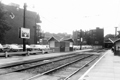 |
Future Site of the Hearthstone Plaza, August 1965
Looking southwest from the Brookline Village T stop at what is essentially todays Hearthstone Plaza. These buildings, save those in the center on the south side of Lower Washington St., were razed in the next 2-3 years for the Plaza project. From left to right:
- Partial view of the rear wall of the movie theater at 105 Washington St.
- Partial view of the rear of the four-story apartment building at 127-131Washington St.
- The fire station and buildings on High St. south of Lower Washington St. which still stand
- The buildings from 137-175 Washington St.
From a notebook of property-appraisal photos taken in 1965 and early 1966 for The Marsh Urban Renewal Project run by the Brookline Redevelopment Authority. Only a few scattered peripheral structures remain today.
|

