 |
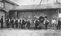
Hose Company #3, Chapel St. Station, Early 1880s
Located across the tracks of the Boston and Albany Railroad at the Chapel St. station. At the time, Carlton St. dipped down to the station. Along the tracks on the other side were several privately-owned buildings where this brick and wood stable owned by Dr. William K. Lawrence was used by Hose Company #3 to store their engine.
In late 1882, a Babcock Chemical Engine acquired by the town and housed nearby on Carlton St. A new company, Chemical Engine #1, was created and appears to have merged with Hose Company #3 in the next year. Chemical Engine #1 moved to their own building at 86 Monmouth St. when it opened in early 1887.
There appear to be two large extinguisher tanks, characteristic of chemical engines, at the front of the wagon in the photo.
[Source: Boston Publishing Co.]
|
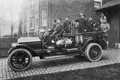 |
Station C, April 1912
Combination Wagon #3, 86 Monmouth St. From left to right:
- John J. McCarthy, hoseman, driving
- John W. Manley, Lieutenant
- Patrick J. Ryan, Hoseman
- William Keegen, Call man
- Michael J. Fahey, Driver
- An agent from American LaFrance, a fire truck vendor
[Source: Boston Publishing Co.]
|
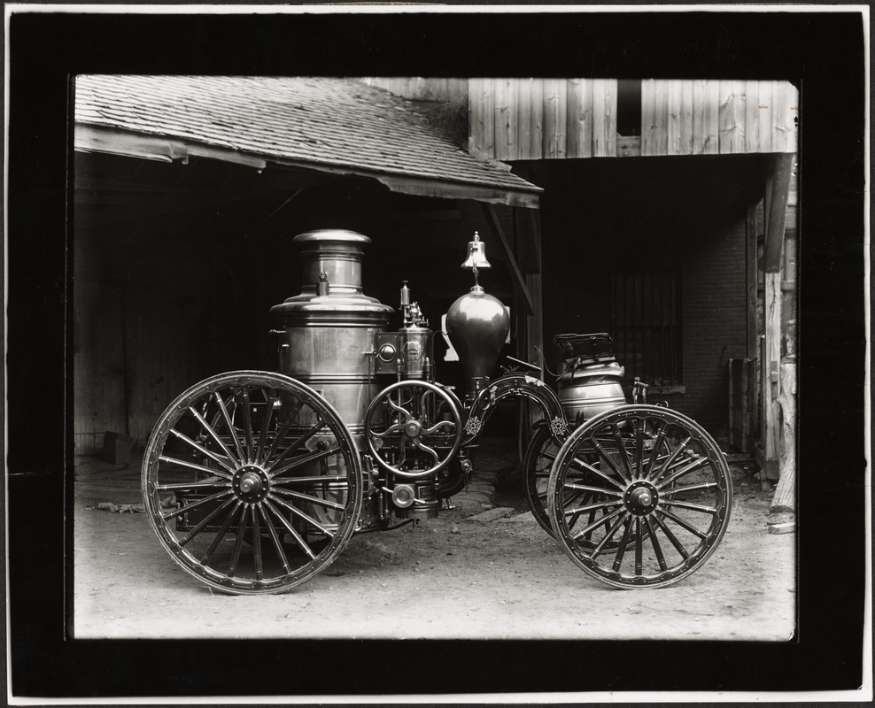 |
Amoskeag Steam Engine
The towns first steam-powered engine, purchased in 1873. Steam-powered pumping of water represented an important improvement over the hand-pumping that was previously required. This photo appeared as part of this article in the March 29, 1956 issue of the Brookline Citizen:
Former Resident Identifies First Brookline Fire Engine
In the 250th anniversary issue of the CITIZEN we used a picture which we had been able to identify only as the first steam fire engine owned by Brookline. Found in the files of the public library, there was no further identification to be had there.
Chief George L. Gettings of the fire department became interested and searched old scrapbooks of the fire department without being able to unearth any further material. We did find advertising pictures of both the Amoskeag and the Hunneman machines but a good deal of comparison with the photograph didnt convince either Chief Gettings or the anniversary issue editor that we were safe in making a statement. There are, after all, too many fire buffs among us these days!
The following very nice letter from Mr. Alfred P. Waterman, who was born in the house still standing at 20 Aspinwall Ave. in 1873, not only answers the question we posed but provides the gratifying information that the citizen gets around. Mr. Waterman writes from his present home at 3142 13th St N, St Petersburg, FL:
I have been reading with much interest the 250th anniversary number of the CITIZEN and wish to congratulate all who had a part in its publication. Having been born in Brookline and having lived there from 1873 to 1938, I found many things in it which were very familiar to me.
Regarding the item on the fire department the Joseph Thomas Waterman mentioned was my father [ed. The 1865 creation of " Good Intent Hose Co." heralded a much more sophisticated approach to fire fighting in the town and the first Board of Fire Engineers was created to oversee those efforts. J. Thomas Waterman was a carpenter who was appointed to the board.] and I know from my family that he went to New Hampshire and gave the order for this engine to the Amoskeag Manufacturing Co. so the engine was an Amoskeag.
He was a member of the Good Intent Hose Company of that time and I believe you will find in the Brookline Town Report of that year about the purchase of this piece of apparatus. If I can be of any further assistance in giving old Brookline information, especially the section from Pond Ave. to Coolidge Corner, please let me know.
[Source: Digital Commonwealth]
|
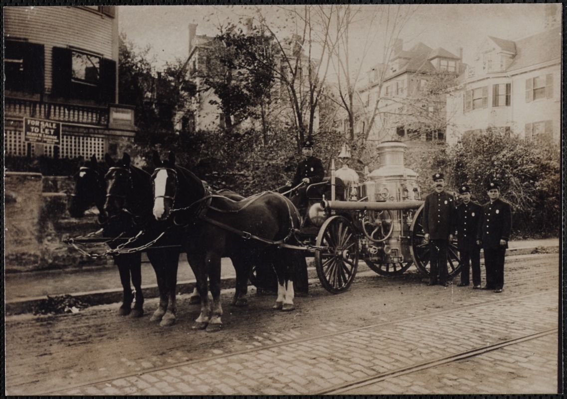 |
Washington Sq. Engine #2 House, circa 1907
The photo is taken across the street from the Washington Sq. fire station which opened in 1900. The station housed both Station G Engine No. 2 and Hook and Ladder No. 1. Shown is the Amoskeag steam engine. All the houses in the photo are still standing. From left to right:
- 666 Washington St.
- Vacant lot where 672/674 1910 Washington St would be constructed in 1910
- 46 University Ave.
- 40 University Ave.
- 676 Washington St.
The tall fire fighter is identified as John F. (Jack) Norton. Born in 1872, he had risen by 1898 to the rank of lieutenant and worked at the Village station. He was at one point discharged (for various infractions and intoxication), but in 1902 the Massachusetts Supreme Court ruled in his favor in his lawsuit against the town to receive back wages withheld at the time of his discharge. In 1905, there was a vacancy in the department when Frank Foster resigned from the force to pursue his business interests. The Fire Commissioner, Burton W. Neal, was then lobbied by supporters of Jack Norton and Neal was reinstated Norton with a position at Station G. where he worked until 1908 as a ladderman. Norton lived in Brookline with his widowed mother, never married, and died in 1910 at the age of 38.
[ref. Brookline Chronicle, pg.4, May 24, 1902]
[ref. Brookline Chronicle, pg.5, July 7, 1905]
[ref. Brookline Chronicle, pg.7, July 8, 1905]
[Source: Digital Commonwealth]
|
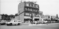 |
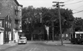
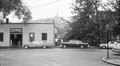
Lower Washington St., Mid 1960s
Looking at the north side of Lower Washington St. prior to the start of the urban renewal project for the area known as The Marsh. In the center is the building at 127-131 Washington St. housing Sagamore Liquors on the left and The Village restaurant on the right. The large open space on the left had been the site of a wooden building from the 1800s known as Russell Block. In August 1962 the town ordered that it be demolished due to its dilapidated condition and no attempt was made to replace it with the urban renewal project pending. On the right is the building built in 1937 housing the entrance to the movie theater.
[Source: Brookline Preservation Department]
|
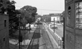 |
Longwood MBTA Stop, 1960s
Standing on the Washington St. bridge looking east on the tracks of the D line by the Longwood stop. In the distance is the massive depot building of the Brookline Coal Co. at 42 Pearl St.
[Source: Brookline Preservation Department]
|
 |
Pearl St.
Looking east on Pearl St. from 21 Pearl St. Six houses on the left, from #24- #38, were removed circa 1960 and replaced with the parking lot next to the Longwood stop on the D line. In the distance is the massive depot building of the Brookline Coal Co. at 42 Pearl St. dwarfing the small building at 40 Pearl St.
[Source: Brookline Preservation Department]
|
 |
Pearl St.
Looking north on Pearl St. Clockwise:
- 68 Pearl St.
- 76 Pearl St. (speculative)
- 84 Pearl St.
- 81 Pearl St. on the corner as Pearl St. takes a right turn toward Brookline Ave.
- 73 Pearl St., garage
- 65-69 Pearl St., garage
[Source: Brookline Preservation Department]
|
 |
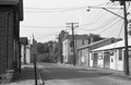
Emerald St.
Looking east on Emerald St. from Pearl St. toward Brookline Ave. before the leveling of the neighborhood in the urban renewal project of The Marsh. From left to right:
- 9 Emerald St., the small house
- 657 Brookline Ave. on the corner
- 660 Brookline Ave.
- 666/670 Brookline Ave.
- Partial view of the auto garage at 676 Brookline Ave.
- A town truck parked at 100 Pearl St., the Brookline Water Dept., a building that still stands
[Source: Brookline Preservation Department]
|
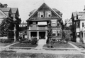 |
33 Bartlett Crescent
[Source: Joel Shield]
|
 |
9 Emerald St.
657 Brookline Ave. is on the right.
[Source: Brookline Preservation Department]
|
 |
657 Brookline Ave.
On the left is Emerald St. looking west toward Pearl St. On the corner is 657 Brookline Ave. followed by #651 and a partial view of #647.
[Source: Brookline Preservation Department]
|
 |
63 Kent St.
Looking east on lower Kent St. at a shed of the Bay State York Co., a heating and refrigeration company whose main location was across the street at 74 Kent St. Station St. enters at the right.
[Source: Brookline Preservation Department]
|
 |
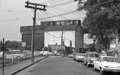
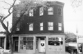
Quinlan Pharmacy., 1186 Boylston St.
Standing on Hammond St. looking south across Boylston St. at 1186 Boylston St., the Quinlan Pharmacy. On the far left is 615 Hammond St., still standing, with 609 Hammond St. next to the pharmacy. On the right of the pharmacy is 1188 Boylston St.
[Source: Brookline Preservation Department]
|
 |
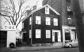
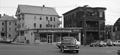
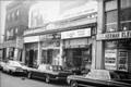
167 and 163 Washington St.
This photo was taken prior to the leveling of the block for the Hearthstone Plaza and the leveling of the entire area then known as The Marsh. The business of the Brookline Bulk Candy was deemed by the Brookline Redevelopment Authority to be neighborhood-specific and was relocated across the street at 216 Washington St. By contrast, the Ames Supply Co., partially viewed on the left, was not given an option to relocated nearby.
[Source: Brookline Preservation Department]
|
 |
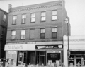
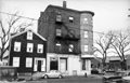
171 Washington St.
The tracks to the D subway line lie immediately to the left. The building anchored the northwest corner of the area then known as The Marsh that would soon be completely leveled in an urban renewal project. Ames Supply Co. was one of thirteen businesses forced out by the Brookline Redevelopment Authority, being deemed not essential to Village Life and therefore not eligible for local relocation on redeveloped land.
[Source: Brookline Preservation Department]
|
 |
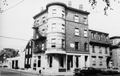
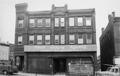
202 -222 Washington St.
All buildings still stand.
[Source: Brookline Preservation Department]
|
 |
645/647 Brookline Ave.
This photo was taken prior to the leveling of the entire area then known as The Marsh.
[Source: Brookline Preservation Department]
|
 |
682/684 Brookline Ave.
Looking east. Gulf service station on the corner of Lower Washington St. is on the right. This photo was taken prior to the leveling of the entire area then known as The Marsh.
[Source: Brookline Preservation Department]
|
 |
Emerald St.
9 Emerald St. is on the left, sideview of 657 Brookline Ave. is on the right. This photo was taken prior to the leveling of the entire area then known as The Marsh.
[Source: Brookline Preservation Department]
|

