 |
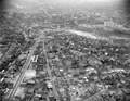
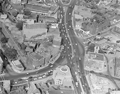
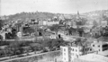
Brookline Village, Aerial View, circa 1958
Looking east on Boylston St. from the corner of Cypress St. (photo, lower left)
FayFoto ID: A91-0915; URL: http://hdl.handle.net/2047/D20395794
[Source: Northeastern University]
|
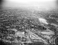 |
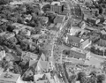
Brookline, Aerial View, circa 1958
Chestnut St. runs along the bottom with High St. in the middle going north towards the Village.
FayFoto ID: A91-0915A; URL:http://hdl.handle.net/2047/D20395789
[Source: Northeastern University]
|
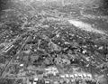 |
Brookline Village, Aerial View, circa 1958
Looking east toward Brookline Village. In the lower left corner is Walnut St. with Oakland Rd. going to the right toward "The Point" neighborhood.
FayFoto ID: A12-1285; URL:http://hdl.handle.net/2047/D20394881
[Source: Northeastern University]
|
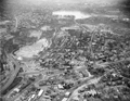 |
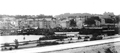
Brookline Village, Aerial View, circa 1958
Looking south at Lower Washington St. going from left to right. The core area south of Lower Washington St., known as "The Farm", was razed in the early 1960s as part of an urban renewal program run by the Brookline Redevelopment Authority. The core area north of Lower Washington St. (lower section of the photo), known as "The Marsh", was razed bit by bit from the mid-1960s to the early 1970s as part of The Marsh Urban Renewal Project run by the Authority.
FayFoto ID: A91-0913; URL:http://hdl.handle.net/2047/D20395787
[Source: Northeastern University]
|
 |
Brookline Village, Aerial View
Only a few of the structures remain today, all located in the lower section of the photo.
FayFoto ID: A67-0333; URL:http://hdl.handle.net/2047/D20395346
[Source: Northeastern University]
|
 |
Harvard St., Aerial View
Looking south toward Brookline Village. The First Presbyterian Church on the right burned down 12/31/1960.
FayFoto ID: A67-0339; URL:http://hdl.handle.net/2047/D20395352
[Source: Northeastern University]
|
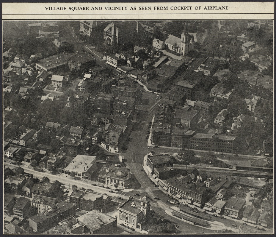 |
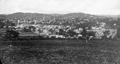
Brookline Village, Aerial View, circa 1930
Looking north.
[Source: Digital Commonwealth]
|
 |
Punch Bowl Tavern
Located on the north side of todays Lower Washington St. at approximately Pearl St. Walnut St. is viewed on the left. This painting is good depiction of early Brookline before the Village became a commercial center. The tavern was a meeting place for British soldiers before the Revolutionary War and when Boylston St., then the Worcester Turnpike, was created in 1806, it became a stage coach stop. The tavern was torn down in 1833 and its timbers were purportedly used in the construction of several houses on White Place.
The painting is by Richard W. Rourke and it was formerly in the collection of the First National Bank: of Boston.
|
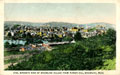 |
Brookline Village, View From Parker Hill
From Postcard
|
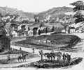 |
Brookline Village, View From Parker Hill, 1854
From Gleason's Magazine.
|
 |
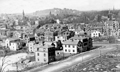
Brookline Village, View From Parker Hill, circa 1874
[Far right to center] Boston's Huntington Ave. (then called Tremont St.); behind it, also running right to left, is Brookline Ave.
[Center-left towards upper left]] Lower Washington St. heads toward Brookline Village. Housing is dense on the north side; the area on the south side known as The Farm, site of today's Brook House, is still predominantly open land.
[Center-left rear] the massive former Town Hall
[Center-right rear] Summit Ave. can be seen going to the top of Corey Hill
|
 |
Brookline Village, Eastern Border at Huntington Ave, Boston
Looking northwest from Parker Hill.
[Foreground, large angled road] Today's South Huntington Ave. (Boston)
[Center photo from left to right] Boston's Huntington Ave. (formerly Tremont St.) transitioning to Brookline's Washington St.
[Center photo, right side] Houses on Boston's Huntington Ave. (formerly Tremont St.) and Downer St.
[ Center photo, left side] Brooklines Pond Ave. enters lower Washington St
|
 |
Houses on Boston Border, Viewed from Brookline
Standing in Brookline on Pond Ave. looking at houses on the northern side of Boston's Huntington Ave (then-named Tremont St.). Transition to Brookline's Washington St. off-photo left. Entrance to Boston's Downer St. is photo center left. Muddy River culvert foreground right.
|
 |
Lower Washington St. at the Boston Line, circa 1909
View From Parker Hill. Brookline Hills in the background. At the extreme left in the center of the photo are the two matching apartment buildings that are located at 165 Pond Ave. (front) and 19 Villa Lane (rear). The large black gasometer tank of the Boston Consolidated Gas Co. is in the middle left and the small white house in front of it is located at 19 Villa Lane.
|
 |
Houses Along Pond Ave.
Brookline Village is in the distance in the right half. Morss Ave. is entering Pond Ave. on the left. The large round holding tank of the Brookline Gas Light Co. is visible center right.
[Source: Brookline Preservation Department]
|
 |
Pond Ave.
Leverett Pond. Rear, right to left: Washington St. goes from the Boston border over the visible stone bridge toward Brookline Village. Left: 7 houses along Pond Ave bisected by Morss Ave., all replaced by the Brook House apartments.
[Source: Smithsonian]
|
 |
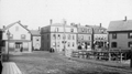
Brookline Ave, December 1916
Looking south. Park Avenue Terrace on the left. Pearl St. on the right in the foreground. Washington St. is visible in the far distance.
[Source: Olmsted]
|
 |
22 Emerald St., Water Dept. (5 Brookline Place today)
Still standing
[Source: Brookline Preservation Department]
|
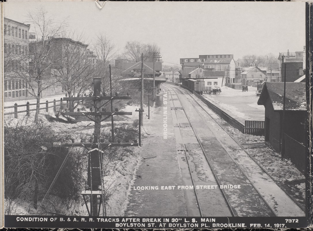 |
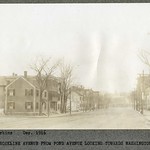
Pearl St., February 14, 1917
From left to right:
- Station St.
- Train station and tracks, looking east, of the Boston and Albany Railroad now used by the MBTA D line
- Open land of the railroad. Behind the horse-drawn cart are houses and businesses on the north side of Pearl St. The sign for Brookline Coal at 40 Pearl St. is visible.
- Automobile on the railroad property. Directly in front of the car and across the street is the house at 31/33 Pearl St.
- Rear of buildings on Fay Place
[Source: Digital Commonwealth]
|
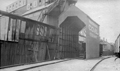 |
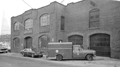
Brookline Coal Co., 40 Pearl St.
The north side of Pearl St. abuts the railroad tracks, today's "D" line, on the east end of Brookline Village.
[Source: Leo Sullivan]
|

