|
The Society
Historical Information
Photo & Map Collections
Exploring Brookline
Links
Program Archives
|
Photo Collection
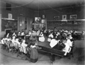 |
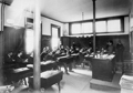
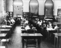
Robert Winthrop School, Kindergarten, 1892
599 Brookline Ave., building still standing. Kindergarten teachers for the 1891-1892 school session were Adeline T. Joyce and Catherine Wentworth.
Page 5, plate 7280. From an album of fifty photographs of Brookline schools, classrooms, and examples of clay modeling, wood-working, and cooking. Produced for the 1893 World's Columbian Exposition.
[Source: Brookline Preservation Department]
|
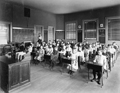 |
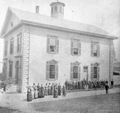
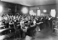
Robert Winthrop School, Second Grade, 1892
599 Brookline Ave., building still standing.
Page 6, plate 7281. From an album of fifty photographs of Brookline schools, classrooms, and examples of clay modeling, wood-working, and cooking. Produced for the 1893 World's Columbian Exposition.
[Source: Brookline Preservation Department]
|
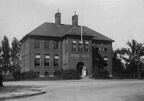 |
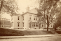
Robert Winthrop School
599 Brookline Ave., still standing.
[Source: Iowa State]
|
 |
Manual Training School
|
 |
Manual Training School, Tappan St.
[l. to r.] Manual Training School building, still standing; Public Baths, no longer standing; Municipal Gymnasium, no longer standing.
|
 |
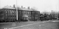
Second High School Building
Looking from Prospect St., School St. is on the right. It was built in 1856, with funds from the bequest of Edward Devotion, and demolished circa 1901. Note the two entrances in front of building, one for boys and one for girls.
|
 |
Second High School Building, With Extensions
Looking from Prospect St., School St. is on the right, the library is in the rear. This is the 1856 high school building with extensions added on both sides. By the late 1880s there was much discussion in town about the need for a bigger building to accommodate the rapidly growing population. These extensions were a stop-gap measure erected in late 1890 before the 1895 opening of the new high school building on Tappan St. It was demolished circa 1901 with the construction of the new Pierce Grammar School.
Page 26, plate 7300. From an album of fifty photographs of Brookline schools, classrooms, and examples of clay modeling, wood-working, and cooking. Produced for the 1893 World's Columbian Exposition.
[Source: Brookline Preservation Department]
|
 |
High School, Drawing Class, 1892
Page 27, plate 7301. From an album of fifty photographs of Brookline schools, classrooms, and examples of clay modeling, wood-working, and cooking. Produced for the 1893 World's Columbian Exposition.
[Source: Brookline Preservation Department]
|
 |
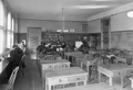
High School, History Room, 1892
Page 28, plate 7302. From an album of fifty photographs of Brookline schools, classrooms, and examples of clay modeling, wood-working, and cooking. Produced for the 1893 World's Columbian Exposition.
[Source: Brookline Preservation Department]
|
 |
High School, Chorus and Orchestra, June 2, 1892
Page 29, plate 7303. From an album of fifty photographs of Brookline schools, classrooms, and examples of clay modeling, wood-working, and cooking. Produced for the 1893 World's Columbian Exposition.
[Source: Brookline Preservation Department]
|
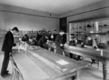 |
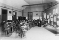
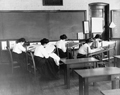
High School, Physical Laboratory, 1892
Page 30, plate 7304. From an album of fifty photographs of Brookline schools, classrooms, and examples of clay modeling, wood-working, and cooking. Produced for the 1893 World's Columbian Exposition.
[Source: Brookline Preservation Department]
|
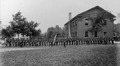 |
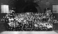
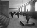
High School, Military Drill, 1892
The group is lined up on the south side of the Pierce Grammar School on Prospect St. In the rear left is the high school.
Page 31, plate 7305. From an album of fifty photographs of Brookline schools, classrooms, and examples of clay modeling, wood-working, and cooking. Produced for the 1893 World's Columbian Exposition.
[Source: Brookline Preservation Department]
|
 |
High School, 1905
[Source: Brookline Preservation Department]
|
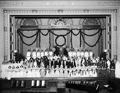 |
Pageant of the Year, Brookline High School, February 28, 1913
From The Chronicle March 1, 1913
THE PAGEANT OF THE YEAR.
On the evening of February 28, an event occurred which marks an important step in the progress of art. A performance - unique in that it was written, acted and managed by High School girls and boys - was presented before the large audience which filled Shailer Hall. The Pageant of the Year, the work of Miss Evelyn Asbrand, '13, was remarkable in many ways. Although the pageant was under the direction of Miss Stone of the Art department, Miss Spaulding of the English department, and Miss Barnes of the Physical Training department, these instructors so acted that practically all the affairs concerning the productions were in the hands of the students.
First to the view of the spectators came Father Time escorted to his throne by the months of the year [ed. these are actually the signs of the Zodiac]. Stately Father Time and the frolicking months! When their march was over, the Seasons came in First Spring, the fair, fresh youth of the year, entered. Along with her came the Breezes, the Mayflowers and the Rain-drops. Then soft and gentle Summer in her sweet flowing robes appeared. Next came Autumn with the School Children, the Witches, the Ghosts, and the Indians. Finally, lmperial Winter ascended the stage, followed by Holly dancers, Winter Sports and others.
...
J. Louis Keegan was Father Time. Miss Madeleine Hunt was Spring; Miss Estelle Krieger, Summer; Miss Mildred Southwick, Autumn; Miss Elizabeth Macnaughtan, Winter. The Months were represented as follows. Georgia Churchill, January; Margaret Woods, February; Dorothy Elden, March, Katharine Delabarre, April; Rosamund Flanders, May. Mary Knowles, June; Carmen Harris, July; Helena von Ladau, August; Ruth Lyman, September; Frances Coburn, October; Helen Goodnow, November; Elizabeth Corbett, December.
The Breezes in their flowing blue draperies were Misses Dorothy Lindsay, Ruth Reizenstein, Eleanor Sheldon, Josephine Kraft, Mary Hickey, and Hilda Shepard. The pattering Rain-drops were Misses Katherine Andrews, Margaret Daniels, Dorothy Wiggin, Margaret Tuttle, Dorothy Champlin, Marion Lawson, Marion Dooley and Alice Kilmer. The Mayflower dance was given by Misses Marguerite Ayers, Margaret Wesner, Dorothy Amsden, Maud Barrett, Marion Neal, Julie Emery, Olive Amsden and Marie Kaan. The graduates to appear were Miss Helen Carvell, Mildred Stronge, Catherine Lally, Marjorie Kaan, Alice Stewart and Evelyn Fisher. Miss Louise Johnson was the School Teacher, while her misbehaving children comprised Esther Sands, Helen McNamara, Grac Stearns, Mary Hickey, Jessie Southwick, Mignonne Ryther and Ethel Driscoll.
The Witches and Ghosts were Misses Edith Driscoll, Caroline Potter, Mary Houghton, and Manon Cook, Helen Kaan, Eleanor Carlisle, Francis Souther and Helene Kornfeld. Ruth Damon was the Chieftain of the Indian group, composed of Helen Fillmore, Margaret Arnold. Marion Forbes, Lillian Hoeffner, Dorothy Izenbeck, Evelyn Kellsher and Mildred Price. The Holly Leaf dance was admirably presented by Misses Dorothy Rhodes, Manon Driscoll, Elizabeth Cantwell, Susie MacDonald, Dorothy Conklin, Ruth Russell, Mary Moran, and Alice Duffy.
The Winter Sports girls were Misses Alice Burdett, Katharine Da VIS, Louise Roberts, Margaret Farley, Caroline Mackey, Julia Bowker, Tsuya Matsuki, Hilda Marrett, Mary Joyce, Elsie Nelson, Florence Putnam, and Elizabeth Taber.
[Source: Brookline Preservation Department]
|
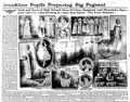 |
Pageant of the Year, Brookline High School, February 28, 1913
Boston Herald, February 23, 1913
|
 |
High School Class in White Embroidery
[Source: Brookline Preservation Department]
|
 |
High School Class in Plain Sewing
[Source: Brookline Preservation Department]
|
 |
High School Class in Embroideries in Color and Shading
[Source: Brookline Preservation Department]
|
 |
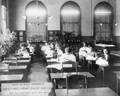
High School Class, Unidentified
[Source: Brookline Preservation Department]
|
 |
High School Class, Unidentified
[Source: Brookline Preservation Department]
|
|

