|
The Society
Historical Information
Photo & Map Collections
Exploring Brookline
Links
Program Archives
|
Recent Additions
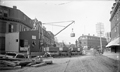 |
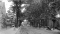
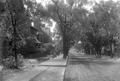
Relocation of the Village Brook, 1893
Looking west on Lower Washington St. toward Boylston St.
(ID) 014
(Slide ID) P-13-18
[Source: William Robert Murphy Collection]
|
 |
Relocation of the Village Brook, 1893
The work on the tunnel was completed in early 1894. Lower Washington St. going toward Boston is to the left. Note that this is one of two different views taken at the same time.
On the north side of Washington St. on the left:
- Unidentified delivery wagon labeled B. Bancroft
- 145 Washington St., awning of Thomas S. Brown & Co., provisions
On the south side of Washington St., from left to right:
- Trolley car on the Cypress St. line
- 106 Washington St., house of Jeremy Guilfoyle with a wagon out front
- 110 Washington St., H. G. Jordan, Coal and Wood, the office and also a sign above the alleyway leading to their coal yard at the corner with Morss Ave.
- 126 Washington St., William Frawley, custom shoemaker (note picture of boot on sign
- 126 Washington St., Luigi Barba (aka Louis Barbour and Louis Barber), fruit
- 128 Washington St., Frank T. Fay, newsdealer, cigars and tobacco
- 134 Washington St., John Barthelmes, hairdresser
- 136 Washington St., Sing Lee, laundry
Tom Condon, Sr. Civil Engineer for Brookline writes:
The work shown is part of the relocation of the outlet of the Village Brook.
(in the pile of lumber in the background you can see a piece of the curved falsework used
to hold the brick arch until the cement mortar set.). Leverett Pond was created from the Muddy River marsh located just south of Washington Street by installing a stop plank manhole (in effect an adjustable height dam) in the new culvert under Washington Street. This stop plank manhole was necessary to hold back the pond since the Charles and therefore the Muddy Rivers were still tidal at that time. Presumably, Alexis French (who was both Olmsted's engineer and the Town Engineer) determined that more flow into this new pond was necessary. To provide this additional flow, the Village Brook which flows alongside what is now the MBTA "D" line was diverted into the culvert shown under construction. The culvert runs east down Washington Street, crosses Walnut Street, runs down Morss Avenue (now discontinued), across Pond Avenue and into Leverett Pond.
(ID) 013
(Slide ID) P-13-13
(Notes) Replaces existing image
[Source: William Robert Murphy Collection]
|
 |
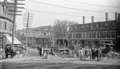
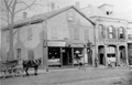
Boylston St., 1912
Looking west on Boylston St. from the Village Square. On the left, from left to right:
- The saw horses of the Simpson Brothers Co. They performed a number of paving jobs in the town.
- 48 Boylston St.: the low stone wall and the two-story brick building still in use in 2026 as a restaurant.
- 50 Boylston St.: apartment building, still standing
- 21 Boylston St.: John H. Shea, Horse Shoer
- 19 Boylston St.: J. O'Day, Stables
On the right is the only known image of the removal of the south side of the Guild Building to accommodate the widening of Boylston St. It was poorly modified and remained a controversial eyesore in the following years. The very next building, 7 11 Boylston St., has just been constructed at the new set back. (ID) 012
(Slide ID) P-6-4
[Source: William Robert Murphy Collection]
|
 |
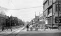
Boylston St. at Cypress St. 1912
Looking east on Boylston St. with Cypress St. on the right. On the corner is the house at 136 Cypress St., no longer standing. To the right is a partial view of 144 Cypress St., still standing. In the middle background are the rears of houses on E. Milton Rd., still standing.
(ID) 011
(Slide ID) P-5-6
(Notes) Replaces existing image
[Source: William Robert Murphy Collection]
|
 |
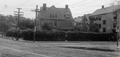
Boylston St., 1912
Looking west from #148. The sign for Walnut Path can be seen in the left foreground followed by the Lincoln School buildings. On the right is the brick Boylston School building (no longer standing) followed by 199-201 Boylston St., still standing.
(ID) 009
(Slide ID) P 5-4
(Notes) Replaces existing image
[Source: William Robert Murphy Collection]
|
 |
11-21 Boylston St., 1912
Looking at the north side of Boylston St., the Village is just to the right. From left to right:
- 21 Boylston St., Napolean L. Walker, Builder
- 21 Boylston St., John H. Shea, Horse Shoer
- 19 Boylston St., J O'Day, Stable (in the rear; office hut in front)
- 11 Boylston St., partial view; O. R. S. Isbister, Sign Painting, Glazing and Window Glass
(ID) 008
(Slide ID) P-5-1
[Source: William Robert Murphy Collection]
|
 |
133,135 Boylston St., 1912
Looking at the north side of Boylston St. From left to right:
- 135/137 Boylston St., the grocery store of Bridget Glynn, partial view. It has already been moved back to accommodate the upcoming widening of Boylston St. Glynn, 50, widowed in 1904, lived with her five children.
- Unexplained band playing for the children
- 133 Boylston St. Not visible in this photo, the house is already being prepared in the rear for the move back to accommodate the upcoming widening of Boylston St. There were two women listed at the address in 1912: Catherine Keenan, 46, and Alice Dawson, 57.
- Driveway leading to the stables and hen house of 133 Boylston St.
- 115 Boylston St., partial view
(ID) 007
(Slide ID) ?
[Source: William Robert Murphy Collection]
|
 |
145-135 Boylston St., 1912
Looking at the north side of Boylston St. From left to right:
- Rear of house on Kerrigan Place, partial view
- 145 Boylston St., an unidentified grocer. The window decorations are very similar to those of the grocery at 135 Boylston St. This building has an ambiguous identity. There had been a larger rooming house there that was no longer listed after 1901. This smaller structure appears in subsequent atlases but there are no records of it in town directories and, notably, no record of the grocery store that is evident. It needed to move back for the widening of Boylston St. and it appears that it was torn down instead, possibly due to the lack of available expansion room - it was right up against a house behind it on Kerrigan Place.
- Delivery wagon. The name Curran displayed on the side but no identification has been made.
- Entrance to Kerrigan Place
- 135/137 Boylston St., the grocery store of Bridget Glynn. It has already been moved back to accommodate the upcoming widening of Boylston St. Glynn, 50, widowed in 1904, lived with her five children there.
- 133 Boylston St., partial view
(ID) 006
(Slide ID) P-5-3
[Source: William Robert Murphy Collection]
|
 |
Boylston St., 1912
Looking west on Boylston St. The Lincoln School is on the left. On the immediate right is a partial view of 199/201 Boylston St. which is still standing.
(ID) 005
(Slide ID) P-5-9
[Source: William Robert Murphy Collection]
|
 |
51-59 Boylston St., 1912
Looking at the north side of Boylston St. From left to right:
- 59 Boylston St., the house of James Healy, partial view, and the entrance to his livery In October, 1912, they were granted a permit to move their house back away from the street.
- 55 Boylston St..
- 51 Boylston St.
(ID) 004
(Slide ID) ?
[Source: William Robert Murphy Collection]
|
 |
145 Boylston St., 1912
Looking at the north side of Boylston St. during the widening of Boylston St. To the right is Kerrigan Place and the houses visible in the rear are on its west side. On the left is 145 Boylston St. This building has an ambiguous identity. There had been a larger rooming house there that was no longer listed after 1901. This smaller structure appears in subsequent atlases but there are no records of it in town directories and, notably, no record of the grocery store that is evident. It needed to move back for the widening of Boylston St. and it appears that it was torn down instead, possibly due to the lack of available expansion room - it was right up against a house behind it on Kerrigan Place.
(ID) 003
(Slide ID) ?
[Source: William Robert Murphy Collection]
|
 |
Boylston St., 1912
Looking at the north side of Boylston St. during the widening of Boylston St. The presence of what appear to be "Y" connectors in the tracks is not understood. From left to right:
- 145 Boylston St., partial view. This building has an ambiguous identity. There had been a larger rooming house there that was no longer listed after 1901. This smaller structure appears in subsequent atlases but there are no records of it in town directories and, notably, no record of the grocery store that is evident. It needed to move back for the widening of Boylston St. and it appears that it was torn down instead, possibly due to the lack of available expansion room - it was right up against a house behind it on Kerrigan Place.
- Entrance to Kerrigan Place
- 137/135 Boylston St. The house has already been moved back from the street and a wooden walkway is visible over the gap.
- 133 Boylston St. Note the open basement walls - the house is already being prepared for a move back to accommodate the upcoming widening of Boylston St. There is a woman in the doorway there were two women listed at the address in 1912: Catherine Keenan, 46, and Alice Dawson, 57.
(ID) 002
(Slide ID) P-5-10
[Source: William Robert Murphy Collection]
|
 |
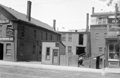
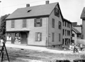
285-289 Washington St., 1903
From left to right:
- 289 Washington St., Morris Salis, Tailor. In 1888, Salis emigrated from Russia at the age of 15. He opened his tailor shop here in 1903 and remained there for over thirty years then moving to the nearby Bowker Block on Harvard St.
- 289 Washington St. To the right of the Salis shop, oddly using the same address, is Charles Lot James, Real Estate whose space also hosts Charles W. Morse, Jeweler. In 1904, both would relocate across the street to 288 Washington St.
- 285 Washington St., the residence and business of Gertrude F. Wallace, hairdresser. The building, with a modified first floor, still stands.
|
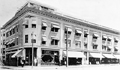 |
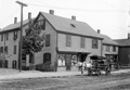
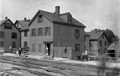
Bowker's Block, 79-87 Harvard St.
On the corner with Aspinwall Ave.is the pharmacy of Arthur W. Bowker
[Source: Brookline Preservation Department]
|
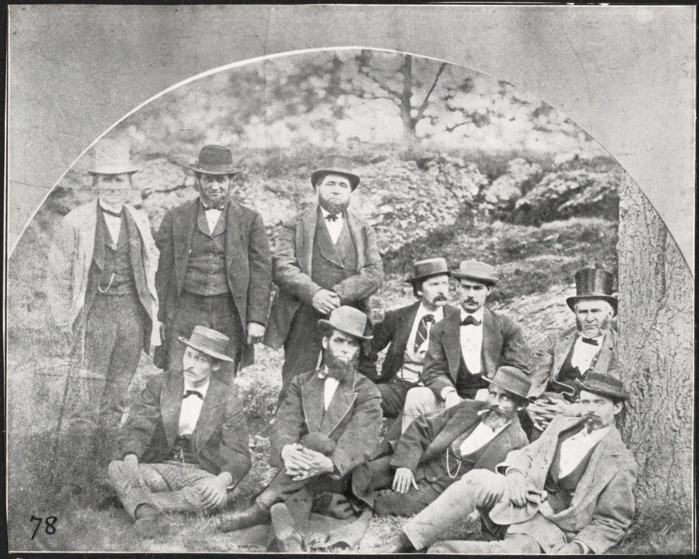 |
Sunday Meeting Group, circa 1870
This group, seen here during an outing by the Providence River, met every Sunday in the back room of Warren G. Curriers drug store in Brookline Village. Most of the men lived close to the store located just north of Davis Ave. on Washington St. This photo appeared on page one of the December 7, 1907 issue of The Brookline Chronicle.
In the back row from left to right:
- Justin Jones, founder and editor of the Boston weekly, the Yankee Blade; he lived on Harrison Place (Kent St.)
- Oliver Cousens, a carpenter whose house and other buildings were on School St.
- Eben Morse, lived in the Village and ran a stable and hackney business there
- Warren G. Currier, owner of the drugstore in Harvard Square where the meetings were held
- Alfred Taylor, a young wool broker who lived in the family house on Harvard St. next to the Baptist Church
- Patrick Dillon, a policeman who lived on Davis Place
In the front row from left to right:
- Joseph Thomas Waterman, a carpenter who lived on Aspinwall Ave. and whose son, Alfred Patterson Waterman, provided the photo to the Chronicle
- Charles Chase, an operator of a delivery service who lived on Washington St. near the library
- Thomas S. Pettingill, sexton of the Baptist Church and town undertaker, who lived on Harvard St. by Aspinwall Ave.
- James H. Boody, a painter who lived in Brookline Village
[Source: Digital Commonwealth]
|
 |
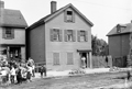
Ingersoll Cunningham and Delia Broderick, 53 Seaver St., 1935
Delia Broderick (1895-1971) emigrated from Ireland in 1915. By 1927, she was a live-in servant for the John Henry Cunningham family on 53 Seaver St. She is shown here with the Cunninghams youngest child, Ingersoll (1923-2020). Never married, she lived at the house for the rest of her life remaining, in her later years, a close friend to the widowed Theresa Cunningham, wife of John.
[Source: Smithsonian]
|
 |
Coolidge Corner
Looking north from Beacon St. at the house at 218 Harvard St.
[Source: Olmsted]
|
 |
Town Hall, June 1874
The third town hall was opened in February 1873. It is reasonably likely that the hall is set up here for the 1874 high school graduation ceremonies. The sign on the rear wall spells out B. H. S. 1874 and appears to match the newspaper description of the 1877 graduation in town hall with a similar hanging made from flowers.
Stereoview by Thomas Lewis, Cambridgeport
|
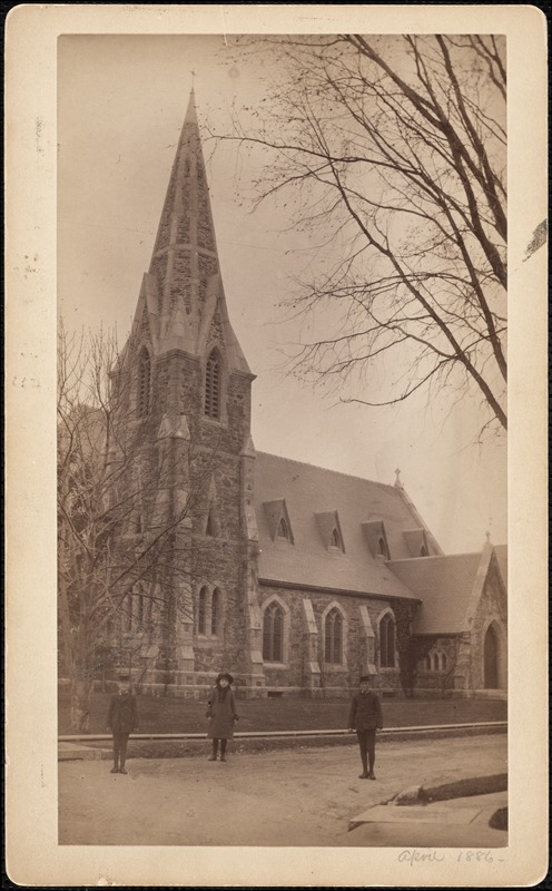 |
Episcopal Church of Our Saviour, Carlton & Monmouth, April 1886
Viewed from Carlton St., Monmouth St. is to the right. The identities of the children are not known. Parenthetically, it is noted that the rector of the church, Reginald Howe, moved his family into the church housing annex around the time of this photo. His daughter was 17 and his son was 11 at the time.
[Source: Digital Commonwealth]
|
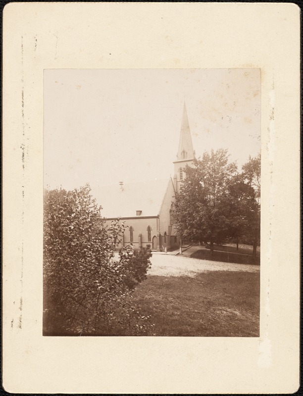 |
First Parish Church, Third Building, 1891
This is the third iteration of the First Parish Unitarian Church shortly before its replacement by the current First Parish Unitarian Church.. It had previously replaced the second building, on the same site, in 1848.
[Source: Digital Commonwealth]
|
|

