|
The Society
Historical Information
Photo & Map Collections
Exploring Brookline
Links
Program Archives
|
Photo Collection
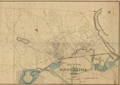 |
Map, 1871, Northeast Half
Item Number: 900-1; Job #900, Boston Parks through 950, Boston, MA (plans)
[Source: Olmsted]
|
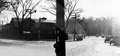 |
Cypress St. and Kendall St., 1937
Cypress St. to the left. Section of the old town trolley barn visible.
|
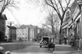 |
Cypress St. and Foley's Market, 1937
Looking north from Rice St. toward Boylston St. Foley's Market is on the right in the same building that houses Foley's Liquors today at 228 Cypress St. Just off-screen to the right is the Lawrence T. Moloney package store. The houses center rear border Mulford St. and are still standing.
|
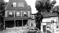 |
230 and 232 Cypress St.
The house built by James Moloney, Sr. where he and wife, Maria, raised their family of 10 children. Son, Lawrence T. Moloney, owned the package store on right. Circa 1940
|
 |
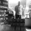
232 Cypress St., Lawrence Moloney Package Store, 1941
Located at the corner of Cypress St. and Rice St., next to Foley's Market. Lawrence Moloney was born in the house next door at 230 Cypress St. After working as a plasterer in his father's business he opened this package store and later moved the business to Boylston St., renaming it Cypress Liquors. Moloney was active in local and state politics and was a Massachusetts state Democratic Party delegate. He was the campaign manager for his sister who was elected as the first female school committee member in Brookline in 1925.
|
 |
Lawrence Moloney Package Store
Located at the corner of Cypress St. and Rice St., next to Foley's Market. Lawrence Moloney was born in the house next door at 230 Cypress St. After working as a plasterer in his father's business he opened this package store and later moved the business to Boylston St., renaming it Cypress Liquors. Moloney was active in local and state politics and was a Massachusetts state Democratic Party delegate. He was the campaign manager for his sister who was elected as the first female school committee member in Brookline in 1925.
|
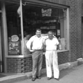 |
Cypress Liquors, Boylston St.
New location of Lawrence Moloney Package Store, after WWII. Pictured on the left is Paul J. Moloney (son of owner, Lawrence T Moloney).
|
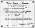 |
James Moloney Citizenship, 1905
His family emigrated from Clare, Ireland to England. He was born in Wales in 1846 as his family traveled there and he grew up in England. He left for the United States in 1866, at the age of 19. He built his home at 230 Cypress St, Brookline and operated a business as a mason/plasterer there.
|
 |
James Moloney and daughter, Margaret Robinson.
|
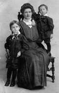 |
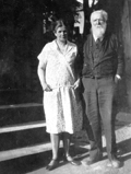
Margaret (Moloney) Robinson with children Preston and W. Lawrence, circa 1907
One of ten children of James Moloney, she and her family lived at 230 Cypress St. with her parents. She served as chair of the Democratic Town Committee; was elected as a member of the School Committee in 1925 and served for six years; and was a Town Meeting member, president of the American Legion Auxiliary of the Brookline Post, and a member of the National Civic Foundation. In 1939, a playground was created at Cypress and Franklin Streets and named the Margaret Robinson Playground.
|
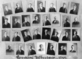 |
Brookline Wheelmen, 1899
Bicycling club. James Moloney, Jr. was president in 1904
|
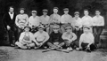 |
Police Baseball Champions, 1916
Rear: Duke Connelly, Mike Cunniff, Tim Killion, Fred Fleming, Pat Rutledge, Sgt. Connors, Jim Casey, George Driscoll, Ed Mac Murray
Front: Joe OConnell, Walter Johnson, Jim Ward, Eddie Moloney, John Donovan
|
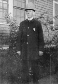 |
Edward Moloney in his Brookline police uniform, circa 1918
Son of James Moloney, Sr., brother to Margaret and James Jr. who are also featured in this collection.
|
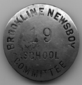 |
The Newsboy badge of James E. Moloney, circa 1938
|
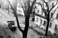 |
Brook St., 1937
|
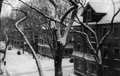 |
Brook St., 1937
|
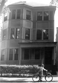 |
86 Brook St., 1941
Home of Lawrence T. Moloney, his wife Katherine, and four children.
|
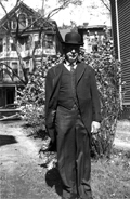 |
Lawrence T. Moloney at 86 Brook St.
Circa 1940. 83 Brook St. is visible in the rear.
|
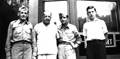 |
Lawrence Moloney and 3 Sons, August 1944
Lawrence Moloney, Jr.; graduated from St. Mary High School in 1937, attended Suffolk University and Georgetown Law School. Despite the fact that he held a civil service job in Washington DC, which exempted him from the military draft, he enlisted in the Army in 1943. He became an officer (Lieutenant) and was deployed overseas with the 128th infantry division in the fall of 1944. He was killed in action December 20, 1944 at Elsenbourne Ridge, Belgium, in the Battle of the Bulge. His body was initially interred in the Field of Flanders, Belgium, but was flown back to the US in 1947 and returned to Brookline where he was buried in a military service at Holyhood Cemetery in Chestnut Hill. Lt. Lawrence T. Moloney Square at the intersection of Cypress and Walnut Streets is named after him.
|
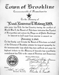 |
Lt. Lawrence T. Moloney, Jr., Proclamation of the Brookline Board of Selectmen
Lawrence Moloney graduated from St. Marys High School in 1937, attended Suffolk University and Georgetown Law School. Despite the fact that he held a civil service job in Washington DC, which precluded him from the military draft, he enlisted in the Army in 1943. He became an officer (Lieutenant) and was eventually deployed overseas with the 128th infantry division in the fall of 1944. He was killed in action December 20, 1944, at Elsenbourne Ridge, Belgium, in the Battle of the Bulge. His body was initially interred by the military in the Field of Flanders, Belgium, but was finally flown back to the US in 1947 and returned to Brookline, where he was buried in a military service at Holyhood Cemetery in Chestnut Hill. Lt. Lawrence T. Moloney Square at the intersection of Cypress and Walnut Sts. is named in his honor.
|
|

