|
The Society
Historical Information
Photo & Map Collections
Exploring Brookline
Links
Program Archives
|
Photo Collection
 |
Boarding house for estate workers
Near corner of Avon St. and Pond St. No longer standing.
|
 |
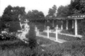
Entrance to the greenhouses, from the inside, Larz Anderson estate
Looking from inside the entrance which is just up the hill from the present-day Larz Anderson museum. The cement pillars, outside wall, and small enclosure are still standing.
|
 |
Greenhouses, Larz Anderson estate
|
 |
Greenhouse, interior, Larz Anderson estate
|
 |
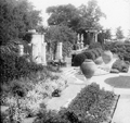
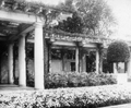
Larz Anderson, Gardens
|
 |
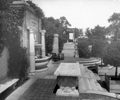
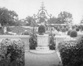
Larz Anderson, Gardens
|
 |
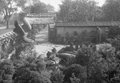
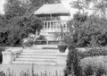
Larz Anderson, Gardens
|
 |
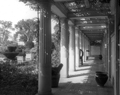
Larz Anderson, Gardens
|
 |
Larz Anderson, Gardens
|
 |
Larz Anderson, Gardens
|
 |
Larz Anderson, Gardens
|
 |
Larz Anderson, Gardens
|
 |
Larz Anderson, Gardens
|
 |
Larz Anderson, Gardens
From postcard
|
 |
Larz Anderson, Japanese Gardens
From postcard
|
 |
Larz Anderson mansion, fire
The estate was given to the town of Brookline in 1948. The then unoccupied mansion became a frequent object of vandalism and the rear was damaged by fire, shown here. The house was deemed too expensive to restore and it was torn down by the town in 1955.
|
 |
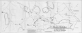
Map of Brookline Marshes, 1818
Drawn up by well-known area surveyor, Mather Withington. This plan and others by Withington would be used in court cases involving land ownership disputes.
|
 |
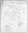
1822 Map of Brookline
[Source: Brookline Preservation Department]
|
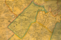 |
Map of Brookline and Surrounding Area, 1852
[Source: Brookline Preservation Department]
|
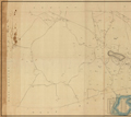 |
Map, 1871, Southwest Half
Item Number: 900-1; Job #900, Boston Parks through 950, Boston, MA (plans)
[Source: Olmsted]
|
|

