 |
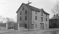
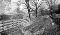
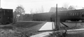
Brookline Waterworks, Pearl St.
This location was the pipe yard for the water department for many years. The rear of the Winthrop School building on Brookline Ave. is to the right.
(ID) 132
(Slide ID) P-24-17
[Source: William Robert Murphy Collection]
|
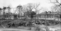 |
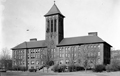
Contagious Hospital, Newton St.
These two hospital buildings and the administration building in the middle were constructed in 1902 on the hill above the Putterham School to isolate and treat the rising number of cases of diphtheria and scarlet fever.
[ref. The Chronicle, October 25th, 1902]
(ID) 127
(Slide ID) P-24-11
[Source: William Robert Murphy Collection]
|
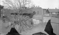 |
Park Department Stables, Pierce St.
On the right is the rear of a house set back from Harvard St. across from St. Mary's church.
(ID) 126
(Slide ID) P-24-9
[Source: William Robert Murphy Collection]
|
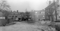 |
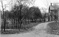
Unidentified, April 30, 1927
Possibly in the Aspinwall Hill area
(ID) 124
(Slide ID) P-9-22
[Source: William Robert Murphy Collection]
|
 |
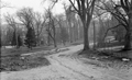
Reservoir Rd., 1903
Looking sorth as the road approaches Boylston St. From left to right:
- Foreground left: the land of Ebenezer Warren Reed that will soon become the site of the Heath School
- 39 Eliot Crescent, on the far left; a three-story apartment building built in 1901, still standing
- Houses on Duffy Court, Eliot Crescent, and Boylston St.
- At the end of Reservoir Road at the corner of Boylston Street the house of Ebenezer Warren Reed
(ID) 123
(Slide ID) P-9-2
[Source: William Robert Murphy Collection]
|
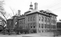 |
Pierce Grammar School, School St.
Opened in 1901 as a replacement for the much smaller school located behind it on Prospect St. No longer standing.
(ID) 122
(Slide ID) P-25-18
[Source: William Robert Murphy Collection]
|
 |
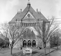
High School
(ID) 121
(Slide ID) P-25-18
[Source: William Robert Murphy Collection]
|
 |
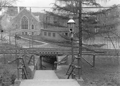
Netherlands Rd. Bridge Over the Muddy River
Looking northwest across Netherlands Rd. at the garage and rear of the house at 203 Kent St.
(ID) 120
(Slide ID) P-28-2
[Source: William Robert Murphy Collection]
|
 |
Longwood School, St. Mary's St.
This is the only known photo of the school.
(ID) 119
(Slide ID) P-25-11
[Source: William Robert Murphy Collection]
|
 |
Parsons School, Walter Ave.
This is the only known photo of the school.
(ID) 117
(Slide ID) ?
[Source: William Robert Murphy Collection]
|
 |
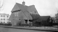
Board of Health Hospital, Newton St.
(ID) 116
(Slide ID) P-24-5
[Source: William Robert Murphy Collection]
|
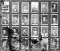 |
Portrait Photos, Town Engineering Dept., 1924
(ID) 114
(Slide ID) ?
[Source: William Robert Murphy Collection]
|
 |
Beaconsfield Train Station; October 31, 1917
Standing by the garage for the Beaconsfield Terraces complex looking south at 311 and 317 Clark Rd.
(ID) 112
(Slide ID) ?
[Source: William Robert Murphy Collection]
|
 |
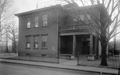
Town Hall, 1919
(ID) 109
(Slide ID) P-24-1
[Source: William Robert Murphy Collection]
|
 |
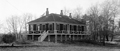
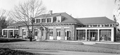
Blake Estate
In the vicinity of the high school but the exact location is not identified
(ID) 108
(Slide ID) P-6-11
[Source: William Robert Murphy Collection]
|
 |
Blake Estate
Standing in the Blake Estate looking across the rear of estate outbuildings and the high school to houses on Tappan St.
(ID) 107
(Slide ID) P-6-8
[Source: William Robert Murphy Collection]
|
 |
Blake Estate Construction, April 30, 1927
The vantage point is from the Blake Estate on the hill above the high school. Stanton Rd. is coming in from the left. In the distance from left to right:
- 80 Greenough St. barely visible through the trees
- Manual Training School barely visible through the trees
- Outbuildings on the Blake Estate, no longer standing but roughly located on the east side of todays Lowell Rd.
- High School
(ID) 106
(Slide ID) P-69-23
[Source: William Robert Murphy Collection]
|
 |
Contagious Hospital, Newton St.
This is probably one of the two wooden buildings built circa 1895 on the hill above the Putterham School to isolate and treat the rising number of cases of diphtheria and scarlet fever. They were replaced by a more substantial complex in 1902.
(ID) 100
(Slide ID) P-24-4
[Source: William Robert Murphy Collection]
|
 |
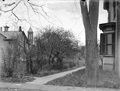
Clinton Path
(ID) 099
(Slide ID) P-34-11
[Source: William Robert Murphy Collection]
|
 |
Blake Rd., April 1933
Looking north as it feeds into Gardner Rd. Photo by the town engineer, Henry Varney, whose car is parked next to the hydrant.
(ID) 096
(Slide ID) P-125-15
[Source: William Robert Murphy Collection]
|

