 |
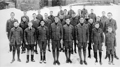
Boy Scout Troop 4, United Parish Church, circa 1927 With Annotations
Troop 4 was affiliated with the First Parish Church and was one of a number of Boy Scout troops in Brookline. The troop, shown here at the church, was largely populated at the time by boys from wealthy families.
[Source: First Parish Brookline]
|
 |
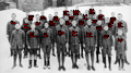
Boy Scout Troop 4, United Parish Church, circa 1927
Troop 4 was affiliated with the First Parish Church and was one of a number of Boy Scout troops in Brookline. The troop, shown here at the church, was largely populated at the time by boys from wealthy families. From left to right:
Front row
- Unidentified
- Robert Mason Whittemore
- John Moore Morse
- Robert Churchill Vose
- Richard Goodwin
- Edward Wiggin Robinson
- Delano Wight
- Crocker Wight
Second row
- Robert H. Schacht
- Robert Ware Bridgeman
- Richard Bent
- Richard Wentworth Pentecost
- Seth Morton Vose
- Charles Storrow Denny
- Russell Hastings
- Henry Waite Bigelow
Third row
- Richard Victor Prouty
- Andrew Marshall
- Irving Minot Shepard
- Cranford Rogers
- Edward Fisk Andrews
- Timothy Rhodes
- Herbert Phelps Vose
- Wendell Morse Hastings
- Anthony Donald Hall
Fourth row
- Robert Hey Rawson
- Cortlandt Van Dyke Hubbard
- Richard Bruce Harding
[Source: First Parish Brookline]
|
 |
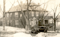
Reservoir Station Trolley Barn
Looking east from Chestnut Hill Ave.
[Source: Joel Shield]
|
 |
Reservoir Station Trolley Barn
Looking east from Chestnut Hill Ave.
[Source: Joel Shield]
|
 |
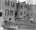
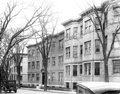
63 Summit Ave.
[Source: Brookline Preservation Department]
|
 |
Boylston St., 1912 (Unconfimred)
These houses are most likely on the north side of Boylston St. just west of the Village Square and are being moved back for the widening of Boylston St. Houses approved in May 1912 for relocation were numbers 75, 91, 95, 99, 107, 109 Boylston St.
(ID) 001
(Envelope ID) P-5-8
(Envelope Description) School St. ?
(Notes) Broken in two pieces; not archived
[Source: William Robert Murphy Collection]
|
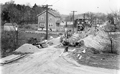 |
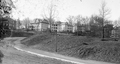
Bonad Rd.
Looking north on Bonad Rd. with Walnut Hill in the distance. C & R Construction, whose equipment is viewed in the photo, won the bid to construct these sewer and drain lines in 1930. On the left side of the road, from left to right are numbers 84, 110, 114,118, 122.
(ID) 163
(Slide ID) P-105-21
[Source: William Robert Murphy Collection]
|
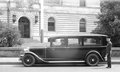 |
Police Ambulance, 1930
(ID) 162
(Slide ID) P-98-5
[Source: William Robert Murphy Collection]
|
 |
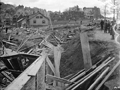
Longwood Ave. Bridge, 1899
Looking toward Boston from Chapel St. The bridge has recently opened and replaced the old wooden bridge there.
(ID) 161
(Slide ID) P-27-11
[Source: William Robert Murphy Collection]
|
 |
1501 Beacon St.
Standing on the south side of Beacon St. looking west. The apartment building at 108-116 Winthrop Rd. is in the upper left corner. In the distance on the right is the six-story apartment building at 1569-1571 Beacon St., still standing. In the foreground is the future location of Brandon Hall at 1501 Beacon St. The pile of debris is unexplained as there was no structure there previously.
(ID) 158
(Slide ID) P-1-4
[Source: William Robert Murphy Collection]
|
 |
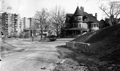
University Rd., 1912
Standing at the eastern end of University Rd. and Washington St. Looking at the rear of houses on Winthrop Rd. Construction of houses on University Rd. has not yet begun.
(ID) 157
(Slide ID) P-27-28
[Source: William Robert Murphy Collection]
|
 |
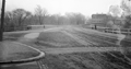
University Rd. and Gardner Rd. Junction, 1912
2 Gardner Rd is on the right, still standing. 555 Washington St. is acorss the street, no longer standing.
(ID) 156
(Slide ID) P-27-22
[Source: William Robert Murphy Collection]
|
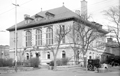 |
Police Station, Jan 31, 1919
(ID) 145
(Slide ID) P-23-14
[Source: William Robert Murphy Collection]
|
 |
Kent St.
Looking north on Kent St. from Linden St. The entrance porch to 122 Kent St. is visible on the left. The bridge over Aspinwall is faintly visible on the right.
(ID) 144
(Slide ID) P-9-8
[Source: William Robert Murphy Collection]
|
 |
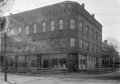
Harvard Square, 1898
Standing in Harvard Square looking at Kent St. From left to right:
- 11 Harvard Sq., Frank F. Seamens, Groceries. Note dated poster in the window.
- Man and unusual wagon on Kent St.
- #9 Harvard Sq., C. A. Delano, Dry Goods
(ID) 143
(Slide ID) P-7-1
[Source: William Robert Murphy Collection]
|
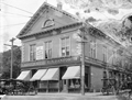 |
Harvard Square, Brookline Village, August 11, 1903
This photo shows the final stage of the full building at 11-13 Harvard Square. On the left, with its delivery wagons parked out front, is T. H. Dyer, Provisions. On the right, at #13 Harvard Sq., is Frank F. Seamens, Groceries recently renamed to L. N. Danforth. It appears that Lucius N. Danforth, a clerk at the Dyer store for two decades and at the George Joyce store there before that, has recently taken over the Seamens store. But the Danforth store will be short-lived. The town had that side of the building removed to allow for the widening of Harvard St. and a new building would replace it in two years.
(ID) 141
(Slide ID) P-14-8
[Source: William Robert Murphy Collection]
|
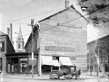 |
Harvard Square, circa 1905
This is a rare photo of the Harvard Hall building just prior to its replacement after a battle with the town and the invocation of eminent domain. The town needed to widen both Washington St. and Harvard St. and was literally shaving off sections of the building which sat at the apex of the two streets. The grocer, T. H. Dyer, insisted on remaining open and the building owner, in litigation with the town, covered the reduced and now-asymmetrical building with makeshift boarding.
(ID) 140
(Slide ID) P-14-12
[Source: William Robert Murphy Collection]
|
 |
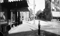
Harvard St. at School St.
Standing on Aspinwall Ave. School St. is on the right with the houses at 16/18 School St. and 2 Prospect St. and the Pierce Grammar School are visible. Harvard Hall at 6 School St. was a large area upstairs used for parties and meetings. The stores, numbered 82-90, are on the west side of Harvard St. The only identifiable one is William Sundell, Painting & Glazing, 84 Harvard St.
(ID) 139
(Slide ID) P-8-8
[Source: William Robert Murphy Collection]
|
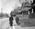 |
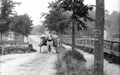
Allerton St.
Looking at the north side of Allerton St. Note the surveyors stick lying on the ground the two men are presumably from the town engineering department. From left to right:
- 14 Allerton St. across High St.
- 28 Allerton St.
- 32 Allerton St.
- 36 Allerton St.
- 44 Allerton St.
(ID) 138
(Slide ID) P-1-1
[Source: William Robert Murphy Collection]
|
 |
Dwight St., 1933
Looking east from Babcock St.
(ID) 136
(Slide ID) P-195-199
[Source: William Robert Murphy Collection]
|

