|
The Society
Historical Information
Photo & Map Collections
Exploring Brookline
Links
Program Archives
|
Photo Collection
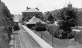 |
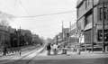
Locomotive of the Boston and Albany Railroad, circa 1910
Heading east at the Brookline Hills Station. The Manual Training School is behind the station The High School is on the right..
|
 |
High School
(ID) 121
(Slide ID) P-25-18
[Source: William Robert Murphy Collection]
|
 |
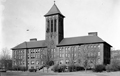
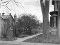
High School, Manual Training School, Bath House
|
 |
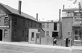
Blake Estate Construction, April 30, 1927
The vantage point is from the Blake Estate on the hill above the high school. Stanton Rd. is coming in from the left. In the distance from left to right:
- 80 Greenough St. barely visible through the trees
- Manual Training School barely visible through the trees
- Outbuildings on the Blake Estate, no longer standing but roughly located on the east side of todays Lowell Rd.
- High School
(ID) 106
(Slide ID) P-69-23
[Source: William Robert Murphy Collection]
|
 |
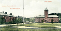
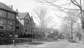
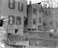
Blake Estate
Standing in the Blake Estate looking across the rear of estate outbuildings and the high school to houses on Tappan St.
(ID) 107
(Slide ID) P-6-8
[Source: William Robert Murphy Collection]
|
 |
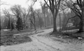
Blake Estate
In the vicinity of the high school but the exact location is not identified
(ID) 108
(Slide ID) P-6-11
[Source: William Robert Murphy Collection]
|
 |
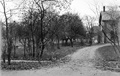
Blake Rd., April 1933
Looking north as it feeds into Gardner Rd. Photo by the town engineer, Henry Varney, whose car is parked next to the hydrant.
(ID) 096
(Slide ID) P-125-15
[Source: William Robert Murphy Collection]
|
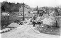 |
Bonad Rd.
Looking north on Bonad Rd. with Walnut Hill in the distance. C & R Construction, whose equipment is viewed in the photo, won the bid to construct these sewer and drain lines in 1930. On the left side of the road, from left to right are numbers 84, 110, 114,118, 122.
(ID) 163
(Slide ID) P-105-21
[Source: William Robert Murphy Collection]
|
 |
Boylston St., 1912
Looking west on Boylston St. from the Village Square. On the left, from left to right:
- The saw horses of the Simpson Brothers Co. They performed a number of paving jobs in the town.
- 48 Boylston St.: the low stone wall and the two-story brick building still in use in 2026 as a restaurant.
- 50 Boylston St.: apartment building, still standing
- 21 Boylston St.: John H. Shea, Horse Shoer
- 19 Boylston St.: J. O'Day, Stables
On the right is the only known image of the removal of the south side of the Guild Building to accommodate the widening of Boylston St. It was poorly modified and remained a controversial eyesore in the following years. The very next building, 7 11 Boylston St., has just been constructed at the new set back. (ID) 012
(Slide ID) P-6-4
[Source: William Robert Murphy Collection]
|
 |
11-21 Boylston St., 1912
Looking at the north side of Boylston St., the Village is just to the right. From left to right:
- 21 Boylston St., Napolean L. Walker, Builder
- 21 Boylston St., John H. Shea, Horse Shoer
- 19 Boylston St., J O'Day, Stable (in the rear; office hut in front)
- 11 Boylston St., partial view; O. R. S. Isbister, Sign Painting, Glazing and Window Glass
(ID) 008
(Slide ID) P-5-1
[Source: William Robert Murphy Collection]
|
 |
11 Boylston St., 1912
O. R. S. Isbister, Sign Painting, Glazing, and Window Glass
(ID) 068
(Slide ID) P 6-3
[Source: William Robert Murphy Collection]
|
 |
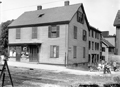
51-59 Boylston St., 1912
Looking at the north side of Boylston St. From left to right:
- 59 Boylston St., the house of James Healy, partial view, and the entrance to his livery In October, 1912, they were granted a permit to move their house back away from the street.
- 55 Boylston St..
- 51 Boylston St.
(ID) 004
(Slide ID) ?
[Source: William Robert Murphy Collection]
|
 |
Boylston St., 1912 (Unconfimred)
These houses are most likely on the north side of Boylston St. just west of the Village Square and are being moved back for the widening of Boylston St. Houses approved in May 1912 for relocation were numbers 75, 91, 95, 99, 107, 109 Boylston St.
(ID) 001
(Envelope ID) P-5-8
(Envelope Description) School St. ?
(Notes) Broken in two pieces; not archived
[Source: William Robert Murphy Collection]
|
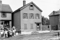 |
133,135 Boylston St., 1912
Looking at the north side of Boylston St. From left to right:
- 135/137 Boylston St., the grocery store of Bridget Glynn, partial view. It has already been moved back to accommodate the upcoming widening of Boylston St. Glynn, 50, widowed in 1904, lived with her five children.
- Unexplained band playing for the children
- 133 Boylston St. Not visible in this photo, the house is already being prepared in the rear for the move back to accommodate the upcoming widening of Boylston St. There were two women listed at the address in 1912: Catherine Keenan, 46, and Alice Dawson, 57.
- Driveway leading to the stables and hen house of 133 Boylston St.
- 115 Boylston St., partial view
(ID) 007
(Slide ID) ?
[Source: William Robert Murphy Collection]
|
 |
Boylston St., 1912
Looking at the north side of Boylston St. during the widening of Boylston St. The presence of what appear to be "Y" connectors in the tracks is not understood. From left to right:
- 145 Boylston St., partial view. This building has an ambiguous identity. There had been a larger rooming house there that was no longer listed after 1901. This smaller structure appears in subsequent atlases but there are no records of it in town directories and, notably, no record of the grocery store that is evident. It needed to move back for the widening of Boylston St. and it appears that it was torn down instead, possibly due to the lack of available expansion room - it was right up against a house behind it on Kerrigan Place.
- Entrance to Kerrigan Place
- 137/135 Boylston St. The house has already been moved back from the street and a wooden walkway is visible over the gap.
- 133 Boylston St. Note the open basement walls - the house is already being prepared for a move back to accommodate the upcoming widening of Boylston St. There is a woman in the doorway there were two women listed at the address in 1912: Catherine Keenan, 46, and Alice Dawson, 57.
(ID) 002
(Slide ID) P-5-10
[Source: William Robert Murphy Collection]
|
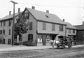 |
145-135 Boylston St., 1912
Looking at the north side of Boylston St. From left to right:
- Rear of house on Kerrigan Place, partial view
- 145 Boylston St., an unidentified grocer. The window decorations are very similar to those of the grocery at 135 Boylston St. This building has an ambiguous identity. There had been a larger rooming house there that was no longer listed after 1901. This smaller structure appears in subsequent atlases but there are no records of it in town directories and, notably, no record of the grocery store that is evident. It needed to move back for the widening of Boylston St. and it appears that it was torn down instead, possibly due to the lack of available expansion room - it was right up against a house behind it on Kerrigan Place.
- Delivery wagon. The name Curran displayed on the side but no identification has been made.
- Entrance to Kerrigan Place
- 135/137 Boylston St., the grocery store of Bridget Glynn. It has already been moved back to accommodate the upcoming widening of Boylston St. Glynn, 50, widowed in 1904, lived with her five children there.
- 133 Boylston St., partial view
(ID) 006
(Slide ID) P-5-3
[Source: William Robert Murphy Collection]
|
 |
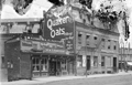
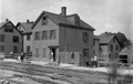
141 Boylston St.
A partial view of the rear of a house facing Kerrigan Place is on the left. To its right is the side of 141 Boylston St. Number 141 needed to move back for the widening of Boylston St. and it appears that it was torn down, possibly due to the lack of available expansion room.
Across the street are, from left to right, the side of 98 Boylston St. (still standing), an outbuilding of 149 Walnut St., and 120/122 Boylston St.
(ID) 086
(Slide ID) P 5-14
[Source: William Robert Murphy Collection]
|
 |
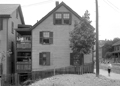
145 Boylston St., 1912
Looking at the north side of Boylston St. during the widening of Boylston St. To the right is Kerrigan Place and the houses visible in the rear are on its west side. On the left is 145 Boylston St. This building has an ambiguous identity. There had been a larger rooming house there that was no longer listed after 1901. This smaller structure appears in subsequent atlases but there are no records of it in town directories and, notably, no record of the grocery store that is evident. It needed to move back for the widening of Boylston St. and it appears that it was torn down instead, possibly due to the lack of available expansion room - it was right up against a house behind it on Kerrigan Place.
(ID) 003
(Slide ID) ?
[Source: William Robert Murphy Collection]
|
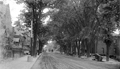 |
Boylston St., 1912
Looking west from #148. The sign for Walnut Path can be seen in the left foreground followed by the Lincoln School buildings. On the right is the brick Boylston School building (no longer standing) followed by 199-201 Boylston St., still standing.
(ID) 009
(Slide ID) P 5-4
(Notes) Replaces existing image
[Source: William Robert Murphy Collection]
|
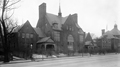 |
Lincoln School
On the right is the Lincoln Grammar School. On the left is the first Manual Training School which opened in 1894. Both buildings became the Lincoln School when the Manual Training relocated to a new building on Tappan St. in 1903. On the far left is the entrance to Walnut Path.
(ID) 050
(Slide ID) P 25-3
[Source: William Robert Murphy Collection]
|
|

