 |
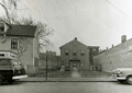
Health Clinic, Brookline Friendly Society, 10 Walter Ave., 1943
The Brookline Friendly Society was a health and human services agency located at 10 Walter Ave. in the area known as The Farm.
|
 |
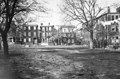
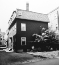
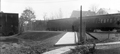
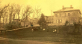
20 Walter Ave.
Boston Globe, October 21, 1963. Viewed from the rear. One of the last houses remaining to be demolished as part of The Farm Redevelopment Project. In the distance the new housing for displaced residents can be viewed, all still standing.
[Source: Northeastern University, Boston Globe Library]
|
 |
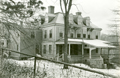
14 Walter Ave.
[Source: Brookline Preservation Department]
|
 |
Walter Ave., Corner with Morss Ave.
Looking from Morss Ave. On the far left is 24 Walter Ave. On the corner is 26 Walter Ave. On the right is 33 Villa Lane.
[Source: Brookline Preservation Department]
|
 |
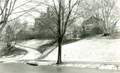
Walter Ave.
Left to right: #63, 59, 57, 55, viewed from Parson's Playground. All razed for the Brook House complex.
|
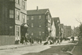 |
Walter Ave.
Looking up Walter Ave. toward Flora St. Near the end of the street on the left is the Parson School which may explain all the children in the photo. The photo appeared in a publication about the Brookline Friendly Society whose main building was at 10 Walter Ave. From left to right:
- 38 Walter Ave. on the southeast corner with Morss Ave.
- 42 Walter Ave.
- 44 Walter Ave.
- 46 Walter Ave.
- 50 Walter Ave.
- 50 Walter Ave.
- Large open space for the Parson School
- 68 Walter Ave. On the northeast corner with Flora St.
- 24 Flora St.
[Source: Brookline Preservation Department]
|
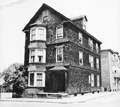 |
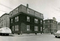
68 Walter Ave.
Flora St. to the right. All razed for the Brook House complex.
[Source: Brookline Preservation Department]
|
 |
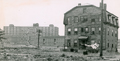
The Farm, Unidentified
[Source: Brookline Preservation Department]
|
 |
Thayer St. and Waverly St, August 17, 1926
Thayer St. is straight ahead.
(ID) 066
(Slide ID) P 63-17
[Source: William Robert Murphy Collection]
|
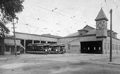 |
Trolley Barn, Boston Elevated Railway Co.
Corner Cypress and Franklin, demolished 1934. The trolleys ran along Boylston to Cypress
[Source: Joel Shield]
|
 |
Reservoir Station Trolley Barn
Looking east from Chestnut Hill Ave.
[Source: Joel Shield]
|
 |
Reservoir Station Trolley Barn
Looking east from Chestnut Hill Ave.
[Source: Joel Shield]
|
 |
Beaconsfield Train Station; October 31, 1917
Standing by the garage for the Beaconsfield Terraces complex looking south at 311 and 317 Clark Rd.
(ID) 112
(Slide ID) ?
[Source: William Robert Murphy Collection]
|
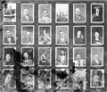 |
Portrait Photos, Town Engineering Dept., 1924
(ID) 114
(Slide ID) ?
[Source: William Robert Murphy Collection]
|
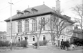 |
Police Station, Jan 31, 1919
(ID) 145
(Slide ID) P-23-14
[Source: William Robert Murphy Collection]
|
 |
Police Ambulance, 1930
(ID) 162
(Slide ID) P-98-5
[Source: William Robert Murphy Collection]
|
 |
PD Unidentified #001
[Source: Brookline Preservation Department]
|
 |
PD Unidentified #002
In a folder labeled "Sewall Ave."
[Source: Brookline Preservation Department]
|
 |
PD Unidentified #003
In a folder labeled "Sewall Ave."
[Source: Brookline Preservation Department]
|
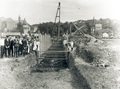 |
Aspinwall Brook and Sewer Project
Looking southeast at Boston just east of todays Aspinwall Park. In the distance on the left is the west side of the Bostons House of the Good Shepherd on Huntington Ave. and on the right is Bostons Parker Hill.
This is most likely work on the Aspinwall Brook or the new sewer line being put in next to it. And it is probable that these are students from The Robert Winthrop School just to the right on Brookline Ave.
[Source: Brookline Preservation Department]
|

