|
The Society
Historical Information
Photo & Map Collections
Exploring Brookline
Links
Program Archives
|
Photo Collection
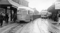 |
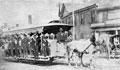
First PCC Streetcar, Brookline Village, circa June 1937
Looking west on Lower Washington St. Shown is PCC streetcar 3001, the very first of a line of new PCC streetcars purchased by the Boston Elevated Railway Co. This car was the only car purchased from the St. Louis Car Co., all subsequent cars being purchased from the Pullman Co. In the rear, the ivy-covered fire station is visible. The waiting platforms in the photo were demolished in September 1938.
It is evident from the No Stops destination panel, and the fact that this car never ran on routes going through Brookline, that this is one of the demonstration/training runs conducted following the delivery of the car in May 1937. The car was given the nickname of Queen Mary and began regular service on June 24, 1937, running on routes that did not go underground as it only had doors opening on the right side. This car has been widely reported on by the enthusiast community and there is even a scale model available for purchase.
|
 |
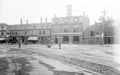
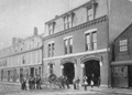
Station A (Now Station 1), circa 1905
Home to Hose Company No. 1, Steam Fire Engine No. 1. The new station house that stands today slightly to the west at 140 Washington St. replaced this house in 1908. Note the mural in the middle of the facade.
|
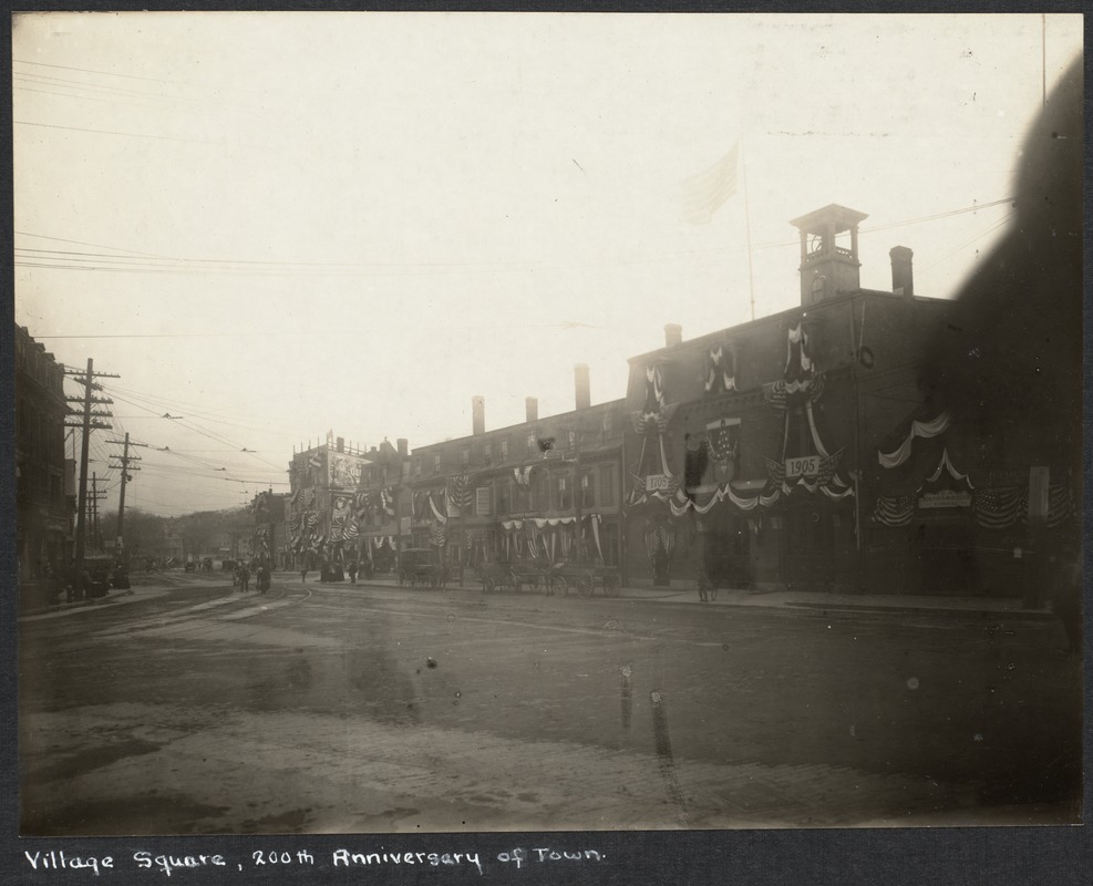 |
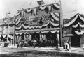
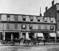
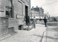
South Side, Lower Washington St., 1905
The stores are bedecked with banners celebrating the bicentennial These buildings were all demolished in 1907-1908 and the current fire station was opened on this site in 1909.
[Source: Digital Commonwealth]
|
 |
Lower Washington St. August, 1933
Looking east from the Village Square
[Source: Leo Sullivan]
|
 |
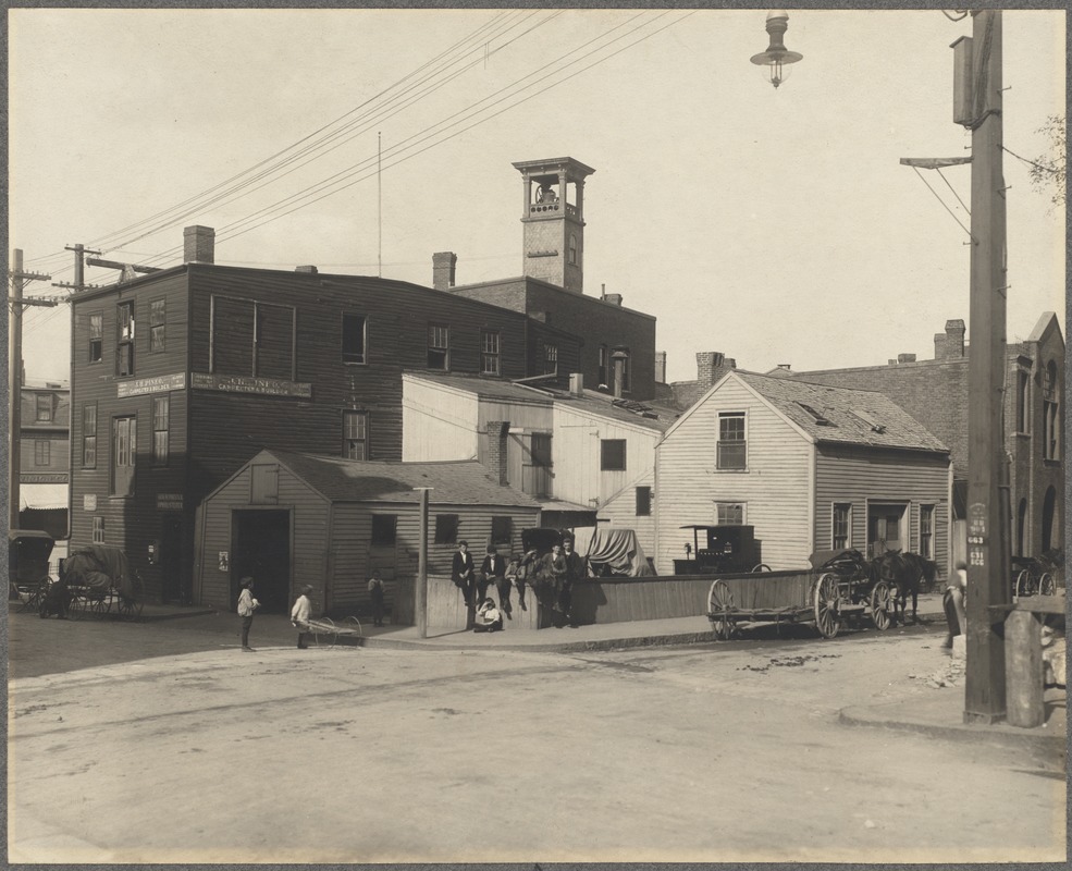
Lower Washington St., Brookline Village, circa 1905
The businesses viewed here, along the south side of Lower Washington St., were simultaneously sited at this location from 1904 - 1906. All the structures in this photo were demolished in 1907-1908 to make way for the new fire station which opened in 1909 and remains in use today. Note the man with his wheeled bucket, center photo, presumably scooping up horse droppings. Viewed from left to right:
- The business with the partial view of an awning is at the corner with Walnut St., the last building in this row. The best estimation is that it is the store of James Heleotis and John Sigalos Co., fruit [1904-1906]. The awning appears to advertise "Ice Cream Sodas" mirroring the sign at the corner entranceway visible in other photos.
- An enigmatic sign over the alleyway that seems to advertise a shooting gallery. This is currently unidentified.
- By the delivery wagon at #126 Washington St. are William Frawley, shoemaker [1889-1907]; and a bootblack, either W. L. Jacklin [1904] or Cromwell Felton [1905-1907].
- C. E. Riley, Cigars at #128 Washington St. [1900-1907]
- The awning at 134 Washington St. George W. Rix, Provisions and Transfer Market [1904-1907]
- Sing Lee, laundry, which was at #136 Washington St. for over 20 years [1883-1907]
- Hose Company No. 1, Chemical Engine No. 1 at #140 Washington St.
- P. J. Burns, Horse Shoe Forge at #144 Washington St. [1897-1907]
- Also at 144 Washington St. there remains a sign for R. Woodward who had a horse-shoeing business there from the 1860s until his death in 1892
- J. H. Pineo, carpenter and builder at 4 High St. (visible at corner of Washington St) [1901-1907]
|
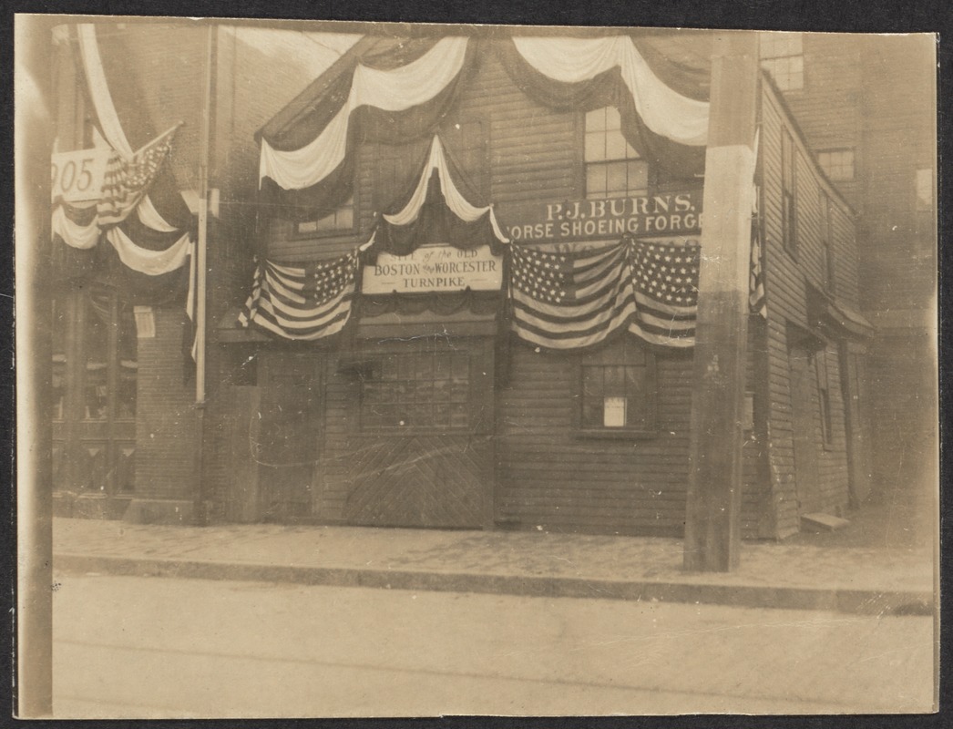 |
P. J. Burns, Horse Shoeing, Brookline Village, 1905
South side of Lower Washington St., #144, corner High St. Hose House 1 is partially visible on the left. Right rear, #4 High St. is partially visible. The fire station is showing banners for the 1905 bicentennial. These buildings were all demolished in 1907-1908 and the current fire station was opened on this site in 1909.
[Source: Digital Commonwealth]
|
 |
Brookline Village, circa 1875
This is a unique early photo of the section of Lower Washington St. that became known as Russells Block. From left to right:
- [145-147 Washington St.] Brown Brothers, Fruits and Vegetables, Provisions
- To the right of the door for the upstairs rooms is an unattributed sign advertising Drain Pipe, Nails, Powder, Soft Lead,
. Hardware
- [137-139 Washington St.] Thomas T. Robinson, Fine Groceries. He had recently taken over the business of Marshall Russell whose sign still remains in the photo.
[Source: Brookline Public Library]
|
 |
Lower Washington St., Brookline Village, circa 1898
Looking east at Lower Washington St. from Boylston St. This photo contains a rare view of the north side of Lower Washington St.
On the far left is the wooden structure known as the "Russell Block". From left to right it houses:
- [153 Washington St.] The kitchenware and variety store of Albert Levien. Levien was a Russian immigrant who arrived in the United States in 1882, at the age of nineteen. He first had a store just over the Boston border on Tremont St. but soon moved to this location in 1888. He lived upstairs for the first sixteen years and maintained the store for over thirty years.
- [145-147 Washington St.] The store with the three awnings is the provisions store of Thomas S. Brown
- [137-139 Washington St.] J. V. Pyne & Co., dry goods
The large brick building to the right of the Russell Block, 127-131 Washington St., houses Jacob Morlock's "Bakery, Restaurant, Provisions" with the Morlock Hotel on the upper floors.
On the right side of the photo, from right to left, the identifiable structures are Hose House #1/Ladder #2 followed by Sing Lees Laundry. Hook and Ladder Co. #2 was only briefly located here, between late 1897 to mid-1899, before moving to the fire station at 342 Washington St.
[Source: Digital Commonwealth]
|
 |
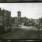
Village Square, November 9, 1899
Looking east at Lower Washington St. from the beginning of Boylston St. At the immediate left, at #1 Boylston St., is the workshop of the Johnson Bros., Masons. The photograph is dated November 9, 1899 by the Town Engineer who was taking elevations for an encroachment case, note the measuring pole held by the man. The latter appears to be the same man holding a pole in this photo.
[Source: Brookline Preservation Department]
|
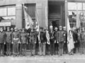 |
Memorial Day, 1923; Lower Washington St., Brookline Village
The Stephen F. Rutledge V.F.W Post #864. P. H. Tonra, Commander. Lower Washington St., Brookline Village. Stores are no longer standing. Current fire house visible, right rear. Edward Moloney is standing under the "JT Driscoll Plumbing" sign, he is the one in a hat instead of a helmet.
|
 |
High St. Corner, Brookline Village, circa 1905
Standing on the corner of Walnut St. and High St. looking northeast towards Lower Washington St. Left, on High St., is the rear of Henry J. Pineo, Carpenter and Builder. On the corner, with Walnut St. going to the right, are several outbuildings of Michael W. Quinlan, Carriages and Harnesses, whose main business is off screen to the left, on the corner of Boylston St. and High St.
[Source: Digital Commonwealth]
|
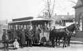 |
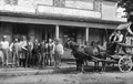
Brookline Village. Horsecar at Morss Ave & Walnut St. Stable, 1893
This is the last remaining horsecar in Brookline. Service began in 1859 and will soon switch to electric. On the right is the corner of the car house at #2 Walnut St. The entrance to Morss Ave. is just to the left of that. #97 Washington St. is viewed left in the rear.
|
 |
Lower Washington St. At Entrance to Walnut St.
Brookline House, 108 Washington St., an eating establishment and boarding house started by Aaron Whitney circa 1865 and closed circa 1874. Comstock, Gove & Co. is making a delivery. A Boston firm, they bottled soda water and eventually expanded to making liquor.
|
 |
Lower Washington St. at Walnut St.
Looking east with Walnut St. coming in from the right. Partial view of the Brookline House, 108 Washington St., an eating establishment and boarding house started by Aaron Whitney circa 1865 and closed circa 1874.
Photo from the Brookline Chronicle, July 8, 1943
|
 |
Lower Washington St., December 23, 1915
Looking west. Foreground left: W.P. Whittemore Co., Hay and Grain, 92 Washington St.; Roeder's Lunch Dairy, in the corner building, 104 Washington St.
[Source: Olmsted]
|
 |
Lower Washington St.
[Source: Brookline Preservation Department]
|
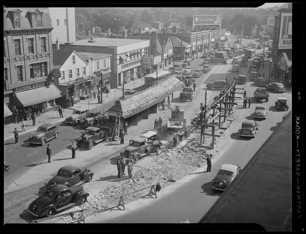 |
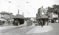
Brookline Village, September, 1938
The two films on the marquee played at the New Brookline Theater from September 8-10. In the distance, a bus prepares to turn right from Brookline Ave. onto Lower Washington St. In an effort to reduce the heavy traffic congestion in the Village, it had recently been decided to substitute busses for the trolleys on the Allston-Dudley route. The trolley transfer stations are being removed. None of the buildings in the photo still stand.
[Source: Digital Commonwealth]
|
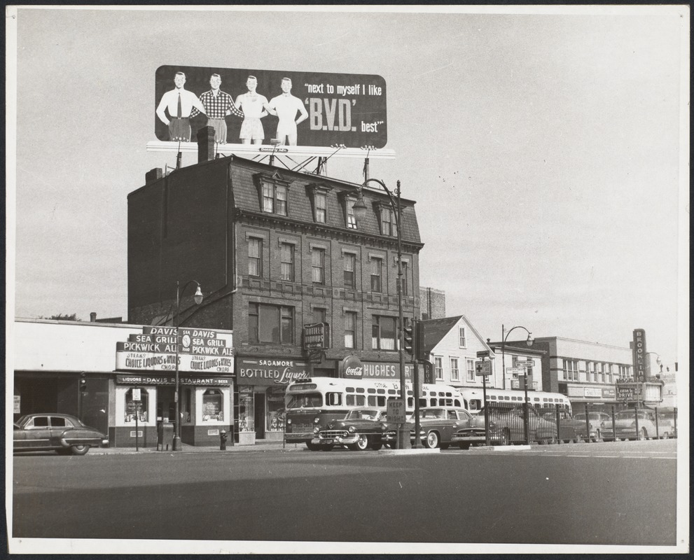 |
Lower Washington St., 1956
From left to right:
- 137 Washington St., Davis Restaurant
- 131 Washington St., Sagamore Liquors
- 127 Washington St., Hughes Pharmacy
- 123/123 Washington St.
- 115/117 Washington St.
- 105-113 Washington St. block including Brookline Village Shoe Store at #109, Mutual Auto School at #107, and the now-closed movie theater
- 103 Washington St., partial view of the White Tower restaurant
[Source: Digital Commonwealth]
|
 |
92-100 Washington St.
The final building at 104-108 Washington St. has recently been demolished and replaced by a gas station (off photo)
[Source: Brookline Preservation Department]
|
 |
Lower Washington St., circa 1875
Start of Boylston St. to the right going west; lower Washington St. toward Boston to the left. The structures to the left of the fire station were collectively known as Whites Block. On the far left on the corner with Walnut St. is a boarding house. In the middle is the sign for Thomas Mayo & Co. which sold furnaces, stoves, and kitchen goods. Immediately to the left of the station is the store of Frederick Sigwart, Cigars.
In the early 1870s the town was progressing to an organized fire-fighting system after years of more haphazard efforts. It created a Fire Department Board of Engineers. It funded this brick building, constructed at significant cost, that was completed in January 1872. In these early years fire houses were designated according to the piece of equipment they hosted. On the left is the Good Intent Hose Company (the hose wagon is pictured in front) which was organized in 1865 and disbanded May 11, 1875. On the right is the Thomas Parsons Steam Fire Engine.
From stereoscope. "Engine and Hose House, Brookline. E.R. Hills, Photographer, Brookline Mass. Gift of Natick Historical Society.
|
|

