|
|
Put On Your Walking Shoes & Step Into the Past:
Spring Walking Tours Blake Park: History of a Neighborhood Led by: Ken Liss of the Brookline Historical Society Date: Sunday, May 19th, 2 pm - 3:30 pm Meet: Brookline High School, 115 Greenough Street Distance: About one mile Register: blakepark051924.eventbrite.com 
President Ken Liss Blogs on Brookline Past & Present
What Do You Call Your Brookline Neighborhood?
The town of Brookline, like many cities and towns, is made up of several neighborhoods. But what are they called and what are their boundaries? The answers to these simple questions are not so simple. Different maps and websites and neighborhood associations may have different names for some of the same parts of town. Or t... Our Latest Archive Additions
We are adding new historical photos weekly. Follow our latest additions here:

Thomas and Bridget (Tonra) Cannon
[Source: University of Massachusetts Boston]
Virtual Walking Tour
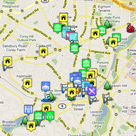 Brookline's rich history can now take a virtual walking tour of the town via our new online map. The map presents pictures and descriptions (with links for more information) about homes, commercial buildings, churches and synagogues, schools, neighborhoods, parks, and other parts of the town.
Most of the sites marked on the map are in Brookline Village, Coolidge Corner, Longwood, and the area around the First Parish Church and the old Village Green. Other sites and other areas of Brookline are being added, helping to bring to light stories behind familiar and not-so-familiar places in town. |
