Aspinwall Hill
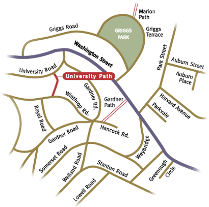
The path's substantial stone steps have remained rooted to the side of Aspinwall Hill for nearly one hundred years and their worn edges and subtle depressions chronicle the countless footfalls of previous climbers. Accepted by the Town on March 19, 1913, University Path is 250.23 feet in length. Beginning on University Road near its intersection with Gardner Road, the path's steps lead up the north slope of Aspinwall Hill, giving convenient passage between University and Winthrop Roads, and ultimately providing better access to Washington Street for the hill's residents. Stone retaining walls flank the path's entrance, calling attention to the inexorable pull of gravity on the sloping hillside. The stone's mossy crevices and cap of tangled vines illustrate the mingling of nature's profusion with a manmade structure. Well constructed and massively scaled, the stonework anchors the path and proclaims its intention to endure. Thick iron handrails are mounted on top of the stone stairs, giving added substance to the sidewalls and security to the climber.
Upon reaching the top of the stairs, the asphalt path continues past adjacent homes. Just beyond, it doglegs to the right and you suddenly find yourself passing through an open area, peering across an expansive backyard on your left. There is an old stonewall in the distance. The yard has the look of a young woodlot as the seedling trees struggle for a foothold in the shade, and its openness is a dramatic contrast to the narrow passageway you just traversed. It seems a bit odd to be viewing this bit of private space. To your right, a weathered wooden fence is a visual barrier for the property just beyond. Some aged oak trees tower over the pathway, blanketing the way in dark shade as you make your way up another set of steps toward Winthrop Road.
Boston University
Had the financial fortunes of Boston University not suffered a downturn due to a devastating fire in 1872, this part of Aspinwall Hill could easily have been home to B.U. classrooms and school buildings. The university owned two parcels of land between Winthrop and Washington, straddling a piece of land owned by William Aspinwall. As it was, the university needed the proceeds from the sale of the land, which had been a gift from Isaac Rich upon his death. After both the university and Dr. Aspinwall, (who owned a substantial portion of land on the hill), sold their land to the Aspinwall Land Company, a joint development plan for the hill was drawn up by Frederick Law Olmsted in 1883. E.W. Bowditch would later revise this plan prior to the hill's development.
University Road was a late addition to the pattern of roadways on Aspinwall Hill, and did not feature in Olmsted's original design. University, Garrison, and Claflin Roads were all added as the final development plan for the hill evolved, making it possible to access additional house lots. Nevertheless, the paths and roadways on Aspinwall Hill represent a comprehensive plan that took advantage of the views and contours in a sensitive way, and provided separate infrastructure to accommodate pedestrians and horse drawn carriages.