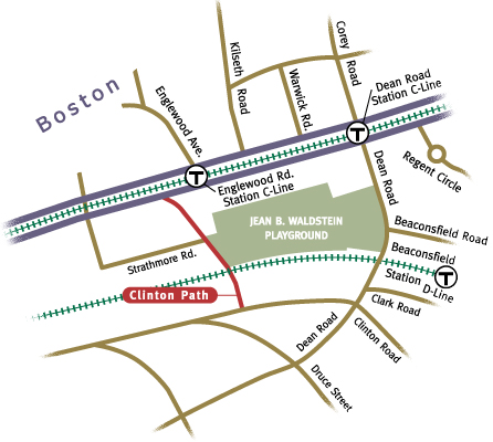
Connecting Clinton Road with Beacon Street, Clinton Path takes a dramatic dip through a tunnel below the MBTA train tracks as it makes its way north. As its most distinctive feature, the tunnel is unique among Brookline's paths. The path begins on Clinton Road, several hundred feet west of Dean Road, where the wide residential street hugs the base of Fisher Hill in a gentle arc. Late 19th century homes nestle on well-proportioned lots that, on the north side, back up to the MBTA train tracks.
Marked with a metal sign, this end of the path is easy to spot. Taking your first steps on the concrete sidewalk, you pass between an allee of tall old oak trees. In the autumn, the random thud of acorns bouncing on the sidewalk grabs your attention, causing you to look up into the trees' canopy. You might also hear the distant thwack of tennis balls rhythmically hitting a backboard as someone earnestly practices their swing on the park's courts. Iron handrails mark the path's borders and guide your passage between the widely-spaced adjoining homes giving the route a spacious and ample feel.
Continuing north, the path gradually descends towards the stairs that carry you down into the tunnel. Like all tunnels, this one, which is made of poured concrete, feels cool and looks dark, despite the lighting hugging the tunnel's ceiling. It's a short tunnel, with a modest dogleg to the left. The graffiti-strewn concrete walls echo your footsteps. It's sufficiently wide, so you don't feel too closed in. From the beginning, you can see through to the end, where the stairs lead up to the open sky and sunshine of the path as it skirts the Jean B. Waldstein playground. The wide green expanse of the park invites a variety of activities from softball to sledding, picnicking, tennis, and sunbathing.
Chinese Christian Church
Continuing on, you pass the Chinese Christian Church at 1835 Beacon Street on your right. After the tunnel, Clinton Path widens to 40 feet and becomes a roadway leading one way towards Beacon Street. While it began life only as a pedestrian way, the 40-foot width of the path proved tempting, and eventually cars from Strathmore Road were accommodated. The 40-foot width of the path is explained by the fact that its right-of-way is superimposed upon a Boston Waterworks (today's MWRA) easement for pipes that once carried water from the Chestnut Hill Reservoir to Boston. The overall length of the path is about 640 feet.
As early as 1868, plans show a path labeled a "Cattle Way" passing under the Boston and Albany railroad. Back then, the train tracks were carried over the path on a bridge, and as you and your cows walked on the stonewall-lined path, you could look up and see the bottom of the rushing trains overhead. Sometime after the path was accepted as a public way in 1901, it was reconstructed as a covered tunnel with substantial steps leading up and down on both sides. Today the path provides a convenient passage for residents of Clinton Road and Fisher Hill heading to the park and Beacon Street.