Reminiscences of Harvard Street
By CHARLES H. STEARNS
Old Harvard Street
By EDWARD WILD BAKER
BROOKLINE, MASSACHUSETTS
PUBLICATION NUMBER SIX OF THE
BROOKLINE HISTORICAL SOCIETY
1935
PUBLICATION NUMBER SIX OF THE
BROOKLINE HISTORICAL SOCIETY
1935
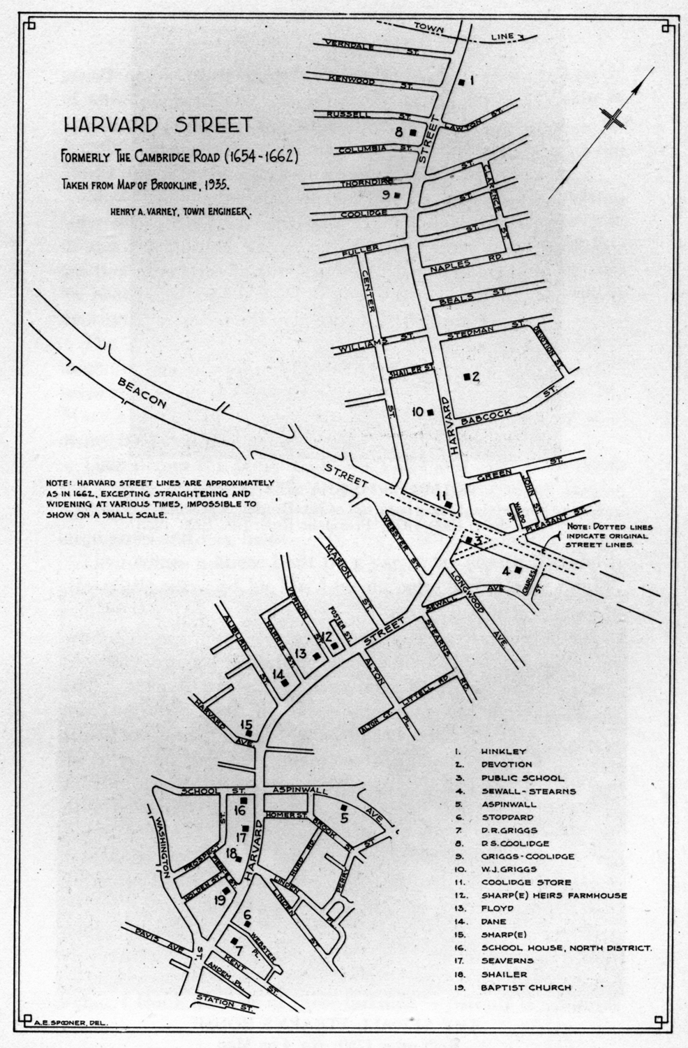
Map of Harvard Street
Locating houses and buildings mentioned in Mr. Stearns' paper
Locating houses and buildings mentioned in Mr. Stearns' paper
As I walked recently along the broad and crowded sidewalk of Harvard Street at Coolidge Corner, and noted the continuous row of shops offering for sale all sorts of goods - and looked at the broad paved roadway with its car tracks - the trolleys - the almost constant crowds of automobiles, I could not help contrasting the narrow, rutted, dusty or muddy road as I remembered it in my youth. The Cambridge Road, as Harvard Street was generally called - the narrow footpath, an apology for a sidewalk, with an occasional farm wagon drawn by a horse, perhaps by a yoke of oxen - perhaps a solitary top buggy, and on Brighton market days, a drove of cattle. The only buildings scattered along the road, the homes of farmers 'with their barns, sheds, hen houses, and piggeries, and the frequent heaps of manure. The contrasts are almost unbelievable.
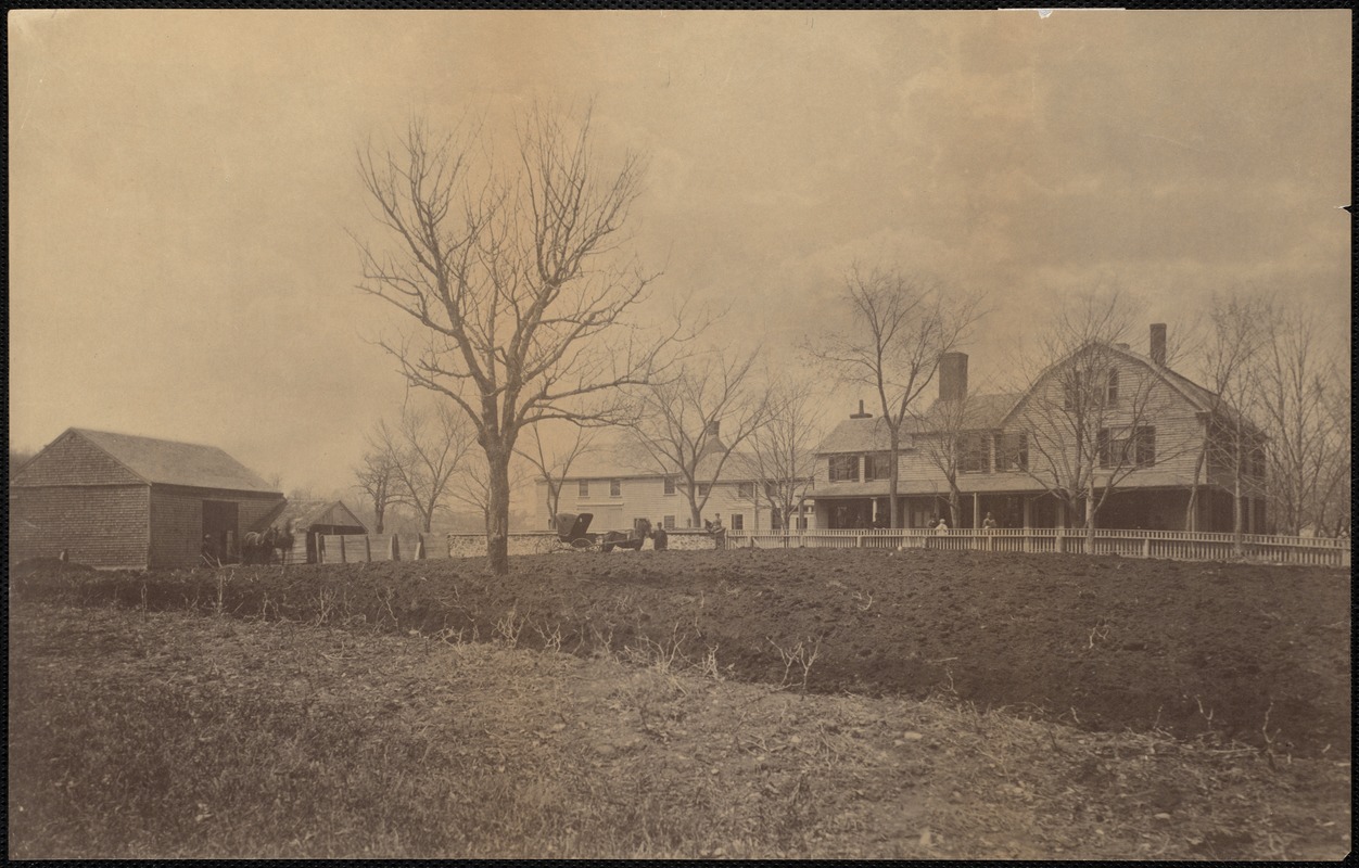
A cursory mention of the houses and estates along the road may be interesting. Beginning at Brighton Avenue, or the Allston-Brighton line, now Commonwealth Avenue, on the northerly side, there was a large lot of land belonging to various parties, notably the Coolidges, who lived on the other (south) side of Harvard Street, which was bought, within my remembrance, by a wealthy gentleman named Hinkley who built a large and handsome house for himself and family; it was a beautiful home. Then came the home of Mr. Babcock, known as the Devotion House - now owned by the town and in care of the Brookline Historical Society. The farm was a large one, with hills and dales, brooks and pond -literally a park in summer and a skating pond and a coasting hill in winter.
This place came into the possession of the Babcock family by a mortgage of one of the descendants of the Devotion family. This farm was carried on by Mr. Babcock for many years, until sold to various parties, among them - the Town of Brookline, who built the large and commodious schoolhouses with ample playgrounds, thus giving to the community and to posterity the benefit of the open frontage.
The next estate was the large and well-known Sewall farm, which had been divided and sold to various parties. Among these new owners was my grandfather, Charles Stearns, who had lived for several years in the Sewall house. I wrote a number of years ago, a detailed account of the house and its many out-buildings, which was published by the Historical Society, and a picture of the house is in the recently published "History of Brookline."
About 1844 a portion of the Sewall Estate was sold in house lots, called Hyde Park, now Green Street, but no houses were built for several years.
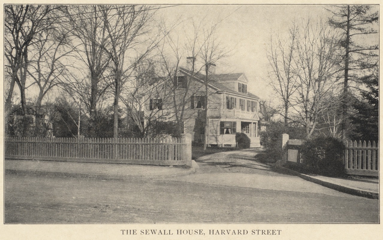
Pleasant Street had been used as a connection of Harvard Street with Brighton Avenue, but, at this time, it was a private lane, and but little used. In 1828, Charles Stearns had built a house for himself on Sewall Avenue near Harvard Street, leaving the occupation of the Sewall house to his sons, who carried on the farm. This house of my grandfather was later moved to Stearns Road, where it still stands.
BEACON STREET BETWEEN PLEASANT AND HARVARD WEST
District School on left; No. 3 on Map
District School on left; No. 3 on Map
[Editor's Note: the camera somewhat distorts the sense of distance in this photograph of Beacon St. before its widening. The small opening on the right in the background is The Coolidge & Brother Store. Beacon St. was widened to its present size by taking land from the south side of the road. The old District School, whose northwest corner is just visible in the left foreground, was removed.]
Photo: Digital Commonwealth
Photo: Digital Commonwealth
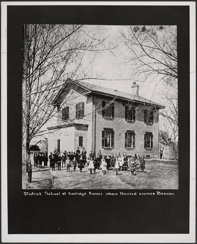
DISTRICT SCHOOL HOSE AT COOLIDGE CORNER
No. 3 on Map; it stood in triangle eliminated by Beacon St. widening
No. 3 on Map; it stood in triangle eliminated by Beacon St. widening
Photo: Digital Commonwealth
The next estate on Harvard Street had been owned by the Sharp family, who lived in a house on the south side of Harvard Street on the corner of what is now Harvard Avenue. The Sharps were prominent people - one of them being a Town Clerk, and, at one time, being the teacher of the School Street school. I do not think a single member of that family or its descendants are now living in Brookline. The present citizens of Brookline of that name, are, I think, not connected with the older family. This land extended along Harvard Street for a considerable distance, but not built upon as I first remember it. At this time, however, the land had probably been divided among the heirs of the family.
We now come along to what is now Aspinwall Avenue, then only a lane to reach the old Aspinwall house, and another house. These were occupied at that time by families named - Perry, and the little road was called Perry's Lane; and a pretty road it was, continuing beyond the buildings to a grove of oak trees, on level ground, sloping off on either side to grassy meadows. This grove was used for picnics. I remember one of the Washingtonians, children of the Cold Water Army.
At the beginning of Perry's Lane; a brook came down from the wash of Corey and Aspinwall Hills and flowed unobstructed, except for the culvert at Harvard Street; the brook at this point widened into a little pool, and, with a large willow tree for shade, made a fine playground for the pupils of the school nearby.
The Aspinwall property was a large one and occupied a large frontage along Harvard Street, I think to about the present Homer Street, and the various buildings of the St. Mary's Parish, which were erected many years after the date of my history.
Then comes the present Linden Place and Street. I think the former owners of this property were the Holden family who lived on Washington Street; as I remember it, it was large grass and hay fields.
Then comes a house built by a carpenter named Stoddard, afterwards occupied by Mr. Lincoln, who had a large family, who were prominent citizens of the town.
Then a house owned by David R. Griggs, well-known in Brookline. This house now fronts on Kent Street, at that time known as Harrison Place, and is owned by the Elks organization.
This brings me to the beginning of Harvard on the north and east sides. This property is now occupied by the Brookline Trust Co.
Beginning at the western or southern side of Harvard Street, near the corner of Brighton Avenue, we come to the large extent of land running up the northerly side of Corey Hill, owned by David Coolidge and, farther along, by Thomas Griggs. Mrs. Coolidge was a Griggs. There were three houses occupied by various families of the Coolidges, all cultivating the Coolidge farm. David Coolidge had seven sons and one daughter; most of them later married and had children. I think but one of these families - parents or children - are living today in Brookline. With their houses and outbuildings they were quite a community.
Then came the extensive farm of Thomas Griggs, extending from Washington Street, the home of Thomas, to Harvard Street. One son, William, lived in a house almost opposite the Devotion House.
I speak of these men as farmers; their vocation literally was market gardeners, raising vegetables for the Boston Market; and a hard task it was, as I know from personal knowledge; working from sunrise to sunset and taking their produce to Boston at night.
Mr. Griggs' land extended along Harvard Street to about the present Webster Street.
The original Beacon Street was not built until 1850, so his estate took in that road all the distance from Harvard to Washington Streets.
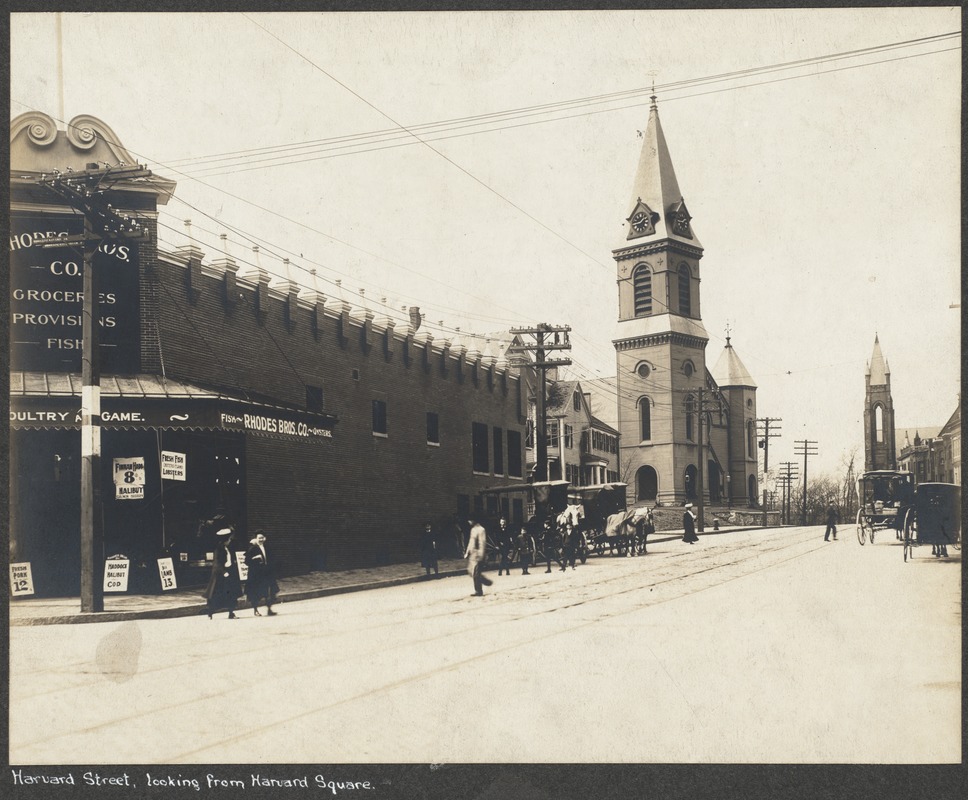
About 1857, a store was built on the corner of Harvard and Beacon, and occupied by two of the Coolidge sons and continued as a mart of trade, until bought by the S. S. Pierce Co., who demolished the building and erected their present establishment. This Coolidge store was a great acquisition to the lonely neighborhood; it was the only store in Brookline, except the ones located in the village, and was not only used largely by the scattered families for trade, but was a convenient place in which to meet one's neighbors. It was a real country store and a common resort on rainy days and also evenings. Probably the name of the proprietors suggested the now universal name of Coolidge Corner. There was a pump in front of the store and a large stone watering trough; there was a hay scale at the end of the building; a familiar group which has been photographed.
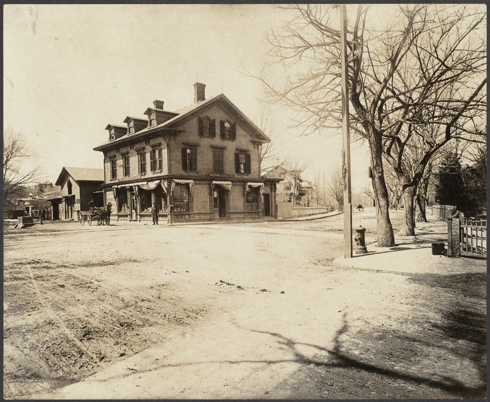
COOLIDGE CORNER LOOKING NORTH UP HARVARD.STREET, IN 1887
Coolidge Brothers' Store in center; No. 11 on Map
Coolidge Brothers' Store in center; No. 11 on Map
Photo: Digital Commonwealth
We come now in our sketch to land belonging to the Sharp family or their heirs, the Crafts or Joneses. The only house I remember on this land was a farm house on the spot where, later, was the Abbott house and still later, the Fosters. Two large elms stood in front of the house. A house was built in the 40's on the corner of what is now Vernon Street, occupied later by the Floyd family, well known in Brookline; this house was ' moved to Aspinwall Avenue. Two small houses stood further along, tom down many years ago.
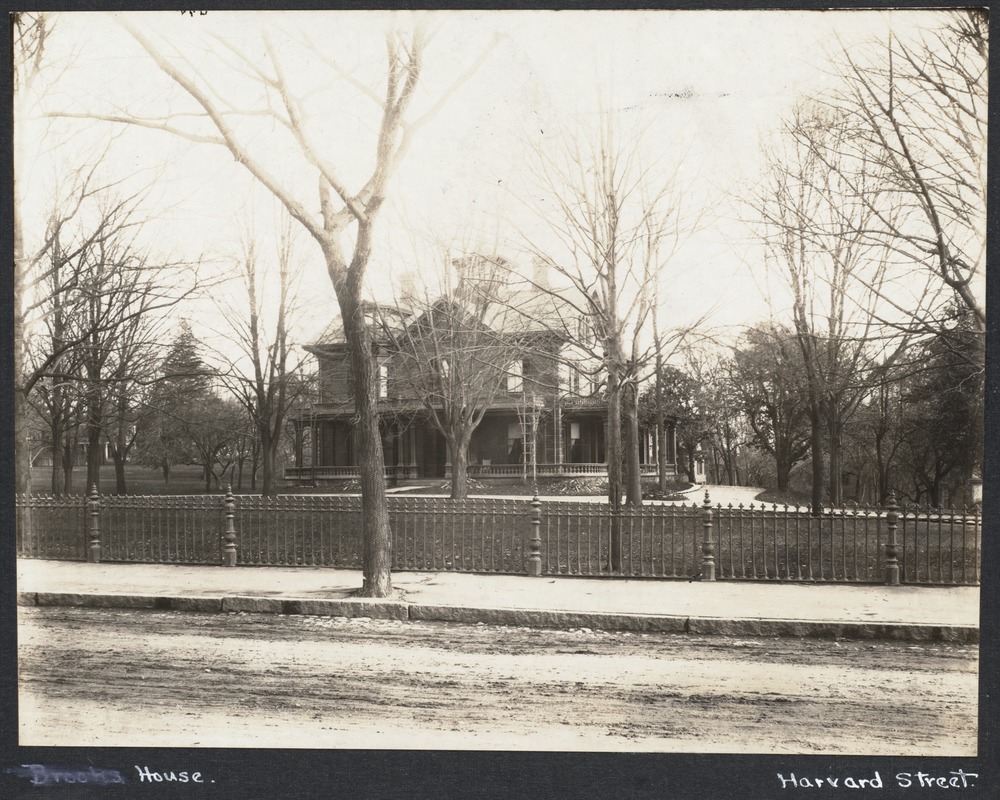
THE GEORGE BROOKS HOUSE, HARVARD STREET
Between Auburn and Vernon Streets, but on the opposite (East) side
Between Auburn and Vernon Streets, but on the opposite (East) side
[Editor's Note: 161 Harvard St., the house Edward C. Wilson. George Brooks lived next door so it is not clear that this is labeled correctly.]
Photo: Digital Commonwealth
Photo: Digital Commonwealth
A large wooden house on what is now Auburn Street was occupied by John Dane, a Boston merchant; he had several boys, who, later, were substantial citizens. He, I think, was the grandfather of Ernest B. Dane, the president of the Brookline Trust Co. This house was later bought by Nathaniel Harris: He moved the building to its present location on Vernon Street and it is now occupied by Dr. Leavitt, the pastor of Harvard Church. Mr. Harris built a brick house on the original site and it is now used as a boarding house. The next building was a large house on the corner of what is now Harvard Avenue. It was on rising ground and was a prominent feature on the street. This was the property and home of the Sharp or Sharpe family. A pleasant story of Schoolmaster Sharpe was given in Miss Woods book about Brookline. This house was moved many years ago to the corner of Harvard Court, and, later, was torn down to make room for a block of stores. The land between the Sharpe house and School Street was low, and when the brook that flowed through it unobstructed, overflowed, as it sometimes did, the ground was soft and swampy, and wild flags and Jack-in-the-pulpits made it quite picturesque.
This brings us to School Street, one of the earlier roadways of the town and built with the continuous Cypress Street to make a highway to Walnut Street and the Meeting House. The so-called North District School House was on this (School) Street. It was the school I early attended. The building was located about where the present Prospect Street begins; it was of two stories; each occupied, taught by a woman teacher, one of whom being an aunt of mine. It was ungraded and attended by children of indiscriminate ages. The land back of the schoolhouse was quite elevated with a high hill top. This high grade extended along Harvard Street, making a very steep road. There were several small houses bordering the street - two of them occupied - one by Thomas Seaverns, a market man of Quincy Market; the other by Dr. William Shailer, minister of the Baptist Church, just beyond. The meeting house occupied the wedge-shaped lot bordering Harvard Street and Washington Street and was backed by a row of horse sheds, making a sort of curved line between the two streets. At about the center of these sheds was a small one-storied building, which towered above the sheds and was reached by a flight of steps behind. This building was used, for a" time, as a school, whether public or private I am not sure, and, I think, the teacher was Miss Harriet Woods, who wrote the pleasant memories of Brookline - a book now out of print. This building had no cellar and one can imagine what a forbidding, forlorn appearance it made and what a cold, bleak condition in winter. I think it had a short life. As the two roads were narrow this wedge of land had quite a space and was covered with grass and trees in front of the meeting house.
This ends Harvard Street and my little story.
Recently on my way to a Harvard-Yale football game at Soldiers' Field, and again when returning, I walked along Harvard Street. As I had done many times before, I stopped a moment near the corner of Brighton Avenue to read the inscription on the bronze tablet which marks the site where formerly stood the home of Col. Thomas Gardner. I venture to say that not one out of a thousand even noticed that tablet, and that not even that one gave a thought as to what it signified in the history of that locality. Not one stopped an instant to remember what that corner stood for in the development of our country. Not one of that great crowd which was traveling over that particular route to the game, paused in their hurry to think what an important part in the history of American Independence had been played by the old highway, now Harvard Street, when, instead of a dozen or more different routes from Boston to Cambridge, there were only two routes from Boston to the Colleges - one by ferry across the river to Charlestown, thence over Charlestown Neck to Cambridge; the other requiring a seven mile journey by land over Boston Neck to Roxbury, thence by way of Brookline and the bridge across the river to Cambridge.
History as a recital of facts with corresponding dates is a matter of memory training, but one's memory does not need training to realize the rapid development of methods of transportation. Only since the beginning of the present century has the automobile become a common and popular vehicle. The electric trolley car was only a laboratory experiment not many years ago. It is only about seventy-five years since the steam railroad was built from Boston to Worcester, through Brighton, passing near the site of Brookline Fort on Sewall's Point, and through what formerly had been the lands of the Gardner family .
It is only about eighty-five years that there has been a comer where the Gardner house stood since Brighton Avenue was not put through until 1821, when it was built as part of the turnpike to Watertown from the Sewall's Point end of the Mill Dam. Previous to that time, for almost two centuries, there had been no direct road to Boston from the Gardner house, and one would have had to go either through Brookline and Roxbury, or, in the other direction, through Cambridge and Charlestown.
In the early years of the Province the records are meagre and disjointed but the facts that steps were taken for providing lines of communication, or highways, between the different communities are clearly set forth.
At the General Court held March, 1634, it was ordered that a sufficient cartbridge should be built over Muddy River, the cost to be contributed equally by Boston, Roxbury, Dorchester, Newtowne (Cambridge), and Watertown. (The bridge was built and the General Court of 1640 apportioned the cost of £15. 3s. 6d between the towns named.)
The people of Cambridge were also taking similar action about the same time. In 1635 provision was made for a causeway and a broad ladder down to low water mark for a convenience in landing from the ferry across the Charles River to the road from Roxbury and Boston. The ferryman was allowed to charge a penny over, and half a penny on lecture days, because although there were then few, if any, inhabitants of Newtowne, or Cambridge, residing on the south side of the river, yet many persons crossed the ferry in going from town to town, especially on lecture days.
With the bridge over Muddy River and the ferry over the Charles River established and fixed points, the line of travel between the two became the next consideration. In 1640 the Boston Records tell us that William Colbron and Jacob Ellyott were appointed to layout the highways at Muddy River towards Cambridge. This is the first record of the laying out of any street or highway within the area which afterwards became the town of Brookline. The particular highway laid out by Colbron and Ellyott was not entirely satisfactory if we may judge by the subsequent entries in the old records. Travel from Boston and the other towns increased rapidly owing to the establishment of the Colleges at Cambridge in 1636, and this no doubt led to the agitation.
Paul Dudley, son of Governor Joseph Dudley, was Chief Justice of the Province of Massachusetts. He died in 1751 and was buried in the tomb of his ancestors in Roxbury Cemetery. I t was Paul Dudley who caused to be set most of the numerous milestones which skirt some of the roads out of Boston. Among others the road to the Colleges in Cambridge was marked by these guides to the traveler of almost two centuries ago.

Photo: Wikipedia

Photo: Wikipedia
The famous "Parting Stone" still stands near the Norfolk House, corner Washington and Centre Streets, Eliot Square, Roxbury. It is of a later date than those already referred to, and the inscriptions are on three sides of an upright square stone:
On the face:The Parting Stone
1744
P. Dudley
On the southerly side:
Dedham
Rhode Island
On the northerly side:
Cambridge
Watertown.
The Gardner family settled in Cambridge in 1725. The line between Brookline and Cambridge was frequently "perambulated" by the representatives of the two towns, as it was not until 1807 that the town of Brighton was incorporated. Previous to that date Brighton was a precinct, or ecclesiastical parish of Cambridge, and known as "Little Cambridge." It contained at that time (1807) a single meeting house, two schoolhouses, and sixty dwelling houses with a population of about four hundred people.
Winship, in his History of Brighton, states that Richard Gardner, in 1747 purchased 110 acres of land, and that the Gardner House was built by Thomas Gardner. It was built principally of oak, fronted south, and the lawn was shaded by three elm trees. The house was built for a home - for his children and his children's children - and it fulfilled its mission on the old site until 1830 when his descendants rented it to others. It was moved from its original site to Allston Street in 1850.
In 1688 there were 28 families, 35 ratable polls, in Brighton. In 1749, just after the Gardner family purchased their real estate, the population of Brighton, as a whole, was only 290 inhabitants. In 1777, the population had increased to 326 which doubled, almost, to 608 in the year 1810. In 1830, it was 972; 1840, 1,425; 1850,2,356; 1860,3,375; 1870,4,967.
In 1780, during the revolutionary period, there were only four houses in what we now know as Allston. The Col. Gardner house, where the tablet marks the site on Harvard Street; the Moses Griggs house, also on Harvard Street on the site of the house formerly occupied by Judge Baldwin; the Richard Gardner house, formerly on what is now Cambridge Street, afterwards owned by Cyrus Dupee; and the Samuel Sparhawk house on what is now Western Avenue, where the sister of Col. Gardner lived and to whose house he was carried after receiving his wound at the Battle of Bunker Hill.
"No contemporaneous description of the primitive days of what we call 'Allston' remains to us, but we can easily picture to ourselves a small rural settlement of scattered farms, with a river front of six miles or more, its principal street running diagonally through it in the direction of the Watertown mill, and one other much traveled highway connecting the seat of government of the colony with its seat of learning." (From Memorial History of Boston.)
Living on this much-traveled highway the Gardner family had great opportunity for gossip and kept themselves well informed as to what was happening outside of their own particular neighborhood. It is not difficult to think of the dignitaries of Church or Colony, traveling on horseback, or in the stately coach, between Boston and the Colleges, stopping at the hospitable old house for rest or refreshment, or just a social chat with the latest news from here or there. We can easily picture the farmers with their cattle or produce journeying to the markets of Boston town stopping to rest at the Gardner house, or when with their families on the way from town to town, breaking their trip for the sake of refreshment and a hospitable gossipy chat with the members of the Gardner family.
As the feeling between the colony and the crown became more and more strained how eagerly the occupants of the old house must have inquired for news from the passing travelers, and nearly everybody traveled the old road to and from Boston and the towns to the north and west.
The neighbors on either hand did not trouble those who lived along the old Cambridge road in the days when our ancestors protested against the Stamp Act, when the Boston school boys demanded their right to coast on The Common without interference on the part of British soldiers, and certain vividly painted Indian, or other, braves brewed the best of tea in the salt water of the harbor.
As nearly as the writer can determine there were not more than twenty-five houses scattered along the old road between the Muddy River bridge and the Great Bridge over the Charles River. Of these several were in Roxbury and two in what was then Cambridge, now the Allston district of Boston.
The line between Brookline and Roxbury in those days was approximately where now Pearl Street and Washington Street make a corner. Between the stream in the Parkway and the Brookline line were three or four houses and a blacksmith shop. The brick blacksmith shop and the old "Long House" as it was called are standing today. Between these, on the same side of the street, was the house once owned by Edward Devotion. Nearer the Parkway was the Wyman place, approximately where the old gas works property is now. In the Devotion House collection today is a sampler presented to the Franklin Historical Society, the handiwork of Rebeca Wyman done in (? ?)
In Brookline proper, the Assessors List of 1774 shows fifteen property taxpayers along the road to Cambridge.
- Eleazer Baker (who at that time owned the Punch Bowl Tavern)
- Francis Blanchard
- James Wesson (who married Ann, daughter of Edward White. He was Colonel and one of the most active officers from Brookline in the Revolution)
- Widow Sarah Davis
- Deacon Ebenezer Davis
- Jona- Jones
- Doct. Wm. Aspinwall
- Capt. Thomas Aspinwall
- Jacob Sharp
- Robert Sharp
- Doct. Eliphalet Downer
- Chas. Winchester
- Widow Mary Winchester
- Solomon Hill
- Thomas Griggs
Do not forget that this old road to Cambridge was one of the most important of the times. Until 1793 there was no comfortable road to the Colleges except this one over Boston Neck through Roxbury and Brookline over the Great Bridge. The only other route from Boston was by ferry to Charlestown and thence over Charlestown Neck to Cambridge.
There was little coach or carriage travel in those days, as Drake, the historian of Boston, states that even as late as 1798 there were only 98 Chaises and 47 Coaches, Chariots, Phaetons, etc., in all Boston.
The old Punch Bowl Tavern which gave the name to the locality stood on the right-hand side of the street where is now the ViIIage Square transfer station in Brookline. In front stood the sign post with the swinging sign showing a punch bowl and lemon tree. Large trees shaded its hospitable entrance and just below was the tavern pump, while, where now is the railroad bridge, the road then crossed the brook where the horses and cattle could get their refreshment which their owners or drivers had enjoyed in the tavern tap room. Leaving Brookline the troops took the "Road to Cambridge" as it is designated on all the old maps. It was not named Harvard Street in Brookline until 1841 when the name was given to "the road from the Baptist Meeting House towards Cambridge." There were no cross streets in that day and the column kept on its straight away march to the causeway and "great bridge" across the Charles River where Soldiers' Field now welcomes the multitudes of spectators to the mimic battles in the gridironed Stadium.
Can any of you picture to yourselves that scarlet-coated army marching along that old road - a road winding along through the meadows and uplands, and shaded by beautiful overhanging trees - the houses of the farmers at widely scattered intervals, and yet a road much traveled between Boston, the surrounding towns, and the Colleges at Cambridge? Can you see on that old road the usual traveler on horseback, alone or with company, perhaps with his wife or some member of his family on the pillion behind, and an occasional chaise or an infrequent coach or chariot with some colonial or ecclesiastical dignitary?
Can you imagine the scene - can you appreciate what must have been the feelings of families along the road as they watched marching by the infantry, the marines, the artillerya scarlet-coated army of 1,200 soldiers, with flags flying, music playing, with baggage train and supplies - the officers no doubt laughing and joking among themselves, and the men in the ranks acting as if they were all out on a practice parade? Indeed, it seems as if the commanding officers could not have realized the seriousness of the occasion, otherwise the boats would have been brought back from Cambridge to the Common and the long march would have been avoided, to say nothing of the saving of most valuable time.
I would it were possible to throw on the screen of your imagination a moving picture of the corner of Harvard Street and Commonwealth Avenue, or of Coolidge Corner on the afternoon of a big college football game, and then follow that picture with others of the same spots as they must have looked on that April day when Lord Percy and his army passed by. Leaving behind the Gardner House the troops followed the road toward the Colleges until they came to the causeway across the meadows and the river spanned by the "Great Bridge." The Selectmen of Cambridge had thought to make the "Great Bridge" impassable. Those who carried out the orders were inexperienced in war, and although they removed the floor boards they did not destroy or carefully conceal them, but piled them not far away on the Cambridge side. Percy's soldiers crossed on the stringers of the bridge and relaid the flooring sufficiently for the troops and artillery without serious delay. The baggage train however was so much delayed that it became separated from the main body and was cut off and captured in Menotomy (now Arlington).
General Heath of Roxbury was one of the Generals who were authorized to take command of the minute men when they should be ordered out. On his way to the scene of action after receiving the alarm, he ordered the planks to be again removed from the bridge, barricades to be erected, and the retreat of the British to be prevented should they return by the same route.
Upon the retreat of Col. Smith's command and Lord Percy's re-enforcements, the more direct route was followed, and instead of taking the angle at Cambridge Common, Lord Percy led his shattered column to Charlestown and under the protection of the guns of the men-of-war.
No one can tell what the result might have been had he attempted to return by way of the Great Bridge, barricaded as it was and defended by men from the towns to the south of the Charles River. Suppose he had attempted to lead those tired soldiers, many of whom had already marched thirty miles, for another eight or nine miles, his column hampered by the wounded in carts or any kind of a vehicle which he had seized for their transportation, then that causeway across the meadows, that narrow bridge across the Charles would have witnessed a struggle as fierce as any of those about which history tells us.
I wish it were possible today to show on the moving picture screen, first the view of Anderson Bridge filled with thousands and thousands on their way to or from a holiday event at the Stadium, and follow it with a reproduction of how it must have looked on that warm spring morning in 1775, a narrow street and a narrower bridge filled with that long drawn out line of soldiers and baggage train, the whole covering the road, causeway and bridge probably from what is now Cambridge Street, Allston, to Harvard Square.
Over this old road, by this corner in front of his cousin Thomas Gardner's home, marched Isaac Gardner of Brookline, Town Clerk and prominent man of affairs, who with others from Brookline responded to the Lexington alarm; and back over the same road the Brookline friends and neighbors of Isaac Gardner brought his body, his life having been sacrificed while resisting the British retreat through Cambridge.
What a throbbing artery of military life the old road must have been in the months following Lexington and Bunker Hill, when the British army of about ten thousand was shut up in Boston by the beseiging army of between sixteen and seventeen thousand. How it must have pulsed with the energy of patriotism as it was marched over and back, between Roxbury on the right and Charlestown on the left, by the troops from New Hampshire, Rhode Island, Connecticut, and all parts of Massachusetts.
As one historian has expressed it - "The environs of Boston presented an animating sight. Hardly a century had elapsed since the two principal passes into the country, Boston Neck and Charlestown Neck, were fortified to save the infant American civilization from the inroads of the savages; now the beautiful hills that surrounded them and commanded them were covered with all the pomp and pride of war to protect the same civilization from being destroyed from without by the same hand which should have protected it. A letter of a British officer in Boston at that time records his impressions in these words:
'The country is most beautifully tumbled about in hills and valleys, rocks and woods, interspersed with straggling villages, with here and there a spire peeping over the trees, and the country of the most charming green that delighted eye ever gazed on.' (Capt. Harris -later Lord Harris.)
"The beauty of nature was now intermingled, on the land with white tents, glittering bayonets, and frowning cannon, while no small portion of the navy of England rode proudly in the harbor. Occasionally the scene was enlivened by a peaceful parade or a hostile skirmish. The sights were no less novel than interesting, and thousands flocked to the neighborhood, either to greet their friends, or to witness the exciting scenes."
In the "Siege of Boston," Rev. Wm. Emerson is quoted as writing: "The Generals Washington and Lee are upon the lines every day. New orders from his Excellency are read to the respective regiments after prayers. . . . Thousands are at work every day from four to eleven o'clock in the morning. . . . It is very diverting to walk among the camps. They are as different in their form as the owners are in their dress; and every tent is a portraiture of the temper and taste of the persons who encamp in it. . . . Some are made of boards and some of sailcloth. Some partly of one and partly of the other. Again, others are made of stone, and turf and brush. Some are thrown up in a hurry; others curiously wrought with doors and windows, done with wreaths and withes in the manner of a basket. Some are your proper tents and marquees, looking like the regular camp of the enemy. In these are the Rhode Islanders who are furnished with tent equipage, and everything in the most exact English style.
"General Washington is described as being truly noble and majestic in appearance, tall and well-proportioned. His dress a blue coat with buff-colored facings, a rich epaulette on each shoulder, buff under dress, and an elegant small-sword; a black cockade in his hat."
For eight months, through summer and winter and until March in the next spring (1776), the occupants of the houses along the old road watched the passing and repassing of the different companies and regiments of raw recruits which patriotism and privations finally developed into the Continental Army. In the night they would be awakened and startled by the mounted messengers galloping at top speed between Generals Ward and Thomas at Roxbury and the Commander-in-Chief at Cambridge. They looked with scorn and disdain on the Boston bound Tories who forsook their homes and property and, with their families, sought protection within the lines of the royal forces; and they pitied, and assisted so far as possible, that ever-lengthening procession of poor exiles from the beleaguered town, who fled from suffering and starvation to seek shelter and support with their friends and fellow patriots in the country outside. That was the time when the Harvard College buildings were used as barracks, when there were forts on both sides of the Charles River, one near where Cottage Farm Station now is, and another on the opposite side: when the Americans were so short of ammunition that window weights and the lead coats of arms on old tomb stones were molded into bullets. What a season of disturbance and anxiety it must have been for the family in the old Gardner House - right in the midst of events, their own family life saddened by the loss of a noble husband and loving father who, at the Battle of Bunker Hill, on that memorable seventeenth of June, laid down his life in defense of home and country.
The story of old Harvard Street from Revolutionary days to the present would be the story of the families who lived along that highway, and in general the story of the growth of the town. Even as late as 1843 there were only fourteen houses between Harvard Square and the Brighton line. The only visible reminders of the days of the beginning of things along the line of the old highway are the milestone and the Devotion House.
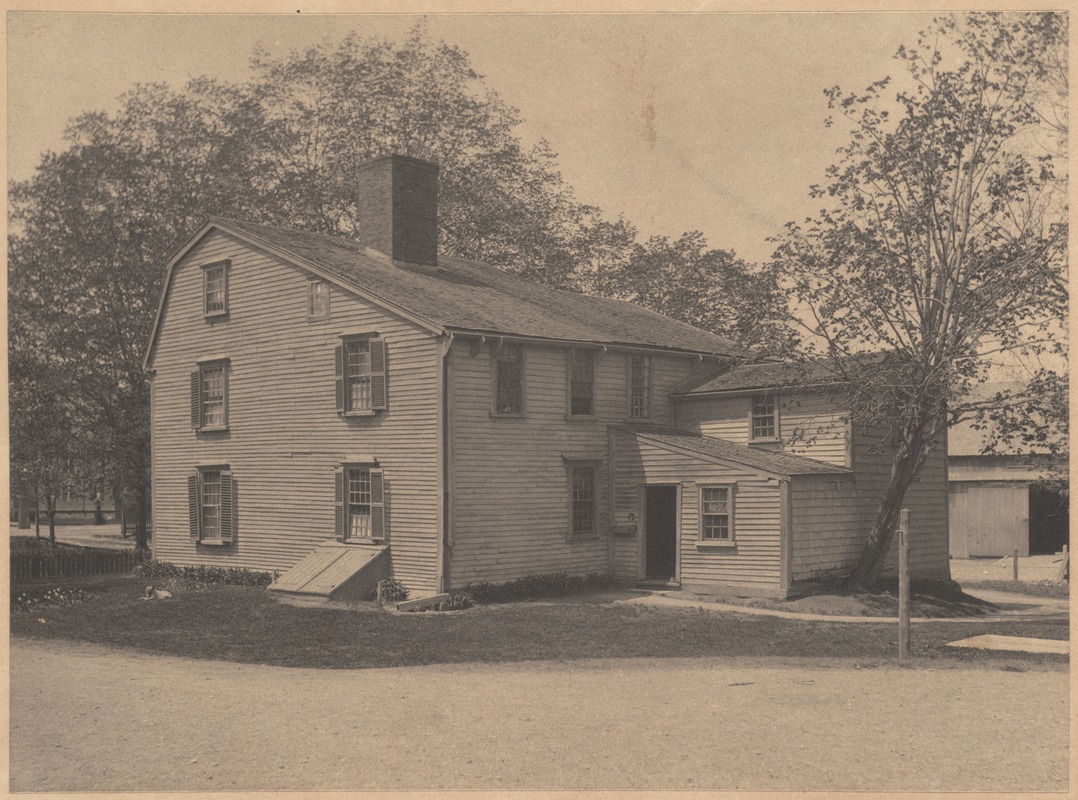
THE EDWARD DEVOTION HOUSE, HARVARD STREET
Built around 1680; No. 2 on Map
Built around 1680; No. 2 on Map
Photo: Digital Commonwealth
The occupants of the old Devotion House, as Doctor Peirce said in 1845, had been successively Edward and Mary Devotion, Solomon Hill, William Marshall, Charles Warren, Rufus and George Babcock. As a boy in Brookline, I remember the place as the Babcock Farm where I went skating on the meadow in winter, and prowled through what was left of the old cedar swamp in summer. Later it was owned by Nahum Smith and, as part of that property, the land and buildings were purchased by the town in 1891 for school purposes. The two fine school buildings were erected later and the disposition of the old house became a question of much discussion, which discussion has at last been settled by putting the house in charge of the Brookline Historical Society. It is to be hoped and expected that the old House will now perform the function of the silent teacher, and by its very presence amid its surroundings impress upon the mind of youth and age, the lessons of love and country and patriotic devotion to the country's progress and glory.
APPENDIX
Notes on the Old Road from Boston to the Colleges made by Mr. Baker in preparation of his paper
"Old Harvard Street"
Notes on the Old Road from Boston to the Colleges made by Mr. Baker in preparation of his paper
"Old Harvard Street"
| 1634 | Sufficient Cartbridge ordered - cost £15 3s 5d distributed Boston, Roxbury, Dorchester, Newtowne (Cambridge) & Watertown. |
| 1635 | Cambridge authorized causeway and broad ladder to low water to ferry to road from Roxbury. Ferryman to charge Id & ~ lecture days. |
| 1636 | Harvard College established. |
| 1640 | Committee to layout highways through Muddy River to Cambridge (First highway in Brookline). |
| 1656 | Bridge authorized. |
| 1657 | Four rod way Muddy River to Watertown Mill. (Connecticut Path.) Stage Coach to New York. |
| 1662 | Bridge completed called the "Great Bridge." Agitation over highway and referees appointed a committee from Roxbury. "Goodman Devotion and Goodman Stevens" (Story about Stevens). |
| 1666 | No oak trees to be cut on Common Land, on account of need of timber to repair bridge. |
| 1676 | Timber prepared for fortifications to be used to repair Great Bridge. |
| 1704 | Sewall Avenue. |
| 1716 | Gov. Shute's Visit - Col. Shute, the newly appointed Governor of Massachusetts and New Hampshire, arrived in Boston October 4, 1716, and on the 15th of the same month commenced a journey to New Hampshire. Instead of crossing the ferry to Charlestown, he passed out of Boston over the Neck, through Roxbury and!)rookline to Cambridge Great Bridge. Great Bridge from time to time repaired and maintained at cost of Newton, Lexington, Arlington, and Brighton all formerly part of Cambridge. |
| 1729 | Paul Dudley Milestones-Son of Gov. Joseph Dudley. Huntington Ave., etc. Parting stone Eliot Square 1744 - On Southerlyside Dedham - Rhode Island. On Northerly side Cambridge - Watertown. |
| 1775 | Twenty-five houses between Muddy River bridge and Great Bridge - some of these in what was then Roxbury - "Long House" - Wyman's Blacksmith Shop - Devotion House. In Brookline 15 houses. |
| 1775 | April 18-April 19. 3 Regiments of Infantry, 2 Divisions of Marines, 2 Pes. Field Artillery. March of British Re-enforcements to Battle of Lexington - Assembled on Tremont Mall- "Long Acre" to Parting stone - Stony Brook - Punch Bowl Village, etc. Planks taken off bridge. Gen'l Heath of Roxbury and his barricade. Siege of Boston-16 to 17,000 troops Roxbury & Dorchester to Gen'ls Ward & Thomas. - Charlestown. Description of Country, of Camps, March of Washington (1789). |
| 1775 | July 3, 1775, Washington took command at Cambridge. Gen'1 Ward, with right wing in Roxbury. Gen'l Lee, with left wing near the Mystic River Cartridges for only 9 rounds. No tents. No uniforms - not much clothing. |
| 1776 | March - Dorchester Heights fortified. 3,000 under Lord Percy attacked but dispersed by storm. Boston evacuated March 17, 1776. |
| 1780 | Only 4 houses in what we now know as Allston: Col. Gardner - Moses Griggs Gudge Baldwin) - Richard Gardner (Dupee) Cambridge St. - Samuel Sparhawk - Western Ave. |
| 1789 | Oct. 24,1789, Washington's Visit to Boston: "In the morning he reviewed Gen'l Brooks' militia on Cambridge Commonj then proceeded through Brookline and Roxbury, and was received at the entrance to the town by the Selectmen and citizens drawn up in two lines extending from Deacon Brown's to the Lamb Tavern, arranged according to their several professions, distinguished by flags and devices." -Belknap Papers. Mass. Rist. Bey. Vol. 5-509. |
| 1793 | West Boston Bridge built - Charles Street to Cambridge (Cambridge St.) diverted travel from Brookline. Until this date only bridge across the Charles near Boston - Harvard Street connecting the seat of government with the seat of learning. |
| 1798 | Drake's History: in all Boston 98 Chaises, 47 Coaches, Chariots, Phaetons, etc. |
| 1806-1810 | Worcester Turnpike. |
| 1807 | Brighton incorporated - 1 Meeting House - >2 Schoolhouses - 60 dwellings - 400 population. |
| 1817 | Watertown Arsenal to build draw. |
| 1835 | Steam Railroad to Worcester. |
| 1847 | Steam Railroad - Brookline Branch. |
| 1851-1852 | Beacon Street in Brookline. Cost $17,500. Abuttors paid $3,500. |
| 1853 | Gas Company. |
| 1862 | General Court authorized Cambridge and Brighton to rebuild "Great Bridge" - releasing all others - with a draw 32 wide the middle of draw to be the dividing line at that point. |
| 1872 | Line changed to St. Marys St. |
| 1879 | Telephone. |
| 1887-1888 | Beacon Street widened. Cost $615,000. Abuttors paid $150,000. |
- Stony Brook - Roxbury Crossing. 1633 - First grist mill built making this a business centre. For more than 100 years the Pierpont family were its proprietors and the locality was known as "Pierpont's Village." Early in 1800 known as Watts Mills - the owner, who occupied an adjoining building for the manufacture of leather breeches. Later it was a morocco factory. Dam and buildings removed in 1870. Tremont St. from Chickering's Factory to Roxbury Crossing opened in 18J2. So much opposition to Tremont St. by people doing business on "the Neck" that the Roxbury end of Tremont St. was completed through private subscriptions.
- Worcester Turnpike started from Village Square.
- Dana's Tavern where Rhodes Bros. store is.
- Davis Estate - Washington & Davis Ave.
- Baptist Church 1828.
- Aspinwall Place 1660.
- Sharp Family.
- Sewall- Wolcott - Stearns.
- Coolidge Comer.
- Stevens - Winchester - Griggs.
- Devotion Family.
- Griggs again.
- Old Gore Homestead. "Remington's Paradise" named from (1653) Lt. John Remington who lived just beyond Parker St. The Comins School stands on a part of this estate.
- The Heath Farm - 54 acres.
- The Brinley place - known as "Datchet House" built about 1723, modeled after the family seat of the Brinleys in Dachet, England. (See Roxbury History p. 327.) This house the headquarters of Gen'l Ward during the siege of Boston. Wine cellar - p. 332. Mission Church 1869.
- Dudley, next to Brinley, passing from Dudley to Ebenezer Francis.
- Davis Estate - two centuries in the same family.
- Craft Estate - built 1709 by Ebenezer, grandson of Griffin. 6 generations of the family lived here.
- Mill Dam - Brookline Avenue - Irish laborers first imported. Stone used principally from Parker Hill quarries.
- Punch Bowl Village - once known as Roxbury Precinct. George Griggs - built the Long House - "Griggs-Downer" house. Mary Griggs married Wm. Wyman - formerly old gas works.
- Devotion House.
- Blacksmith Shop.
- Punch Bowl Tavern - West Point Cadets marched from West Point to Roxbury in the summer of 1821. They numbered 250 and were commanded by Col. Wm. J. Worth. They were met on arrival at the Punch Bowl Tavern by many citizens and the Norfolk Guard who escorted them to their camping ground opposite General Dearborn's residence (Brinley place).
Footnotes
[1] A paper read before the Society January 31, I935.
[2] A paper read before the Col. Thomas Gardner Chapter, Daughters of the American Revolution. December 17. 1907.