The Town Green
(Photo by Jean Stringham)
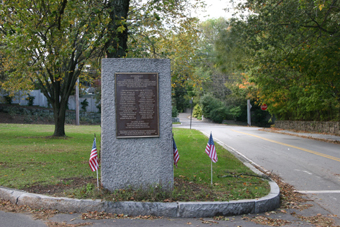
It is an unassuming triangle of grass, and yet the Town Green is the remaining physical witness to the most momentous events in Brookline's history. Today we might think of Coolidge Corner or Brookline Village as the fulcrum around which Brookline life pivots. But for most of the late 17th and 18th centuries, the heart of Brookline was that small triangle of land we still call the Town Green. Located at Warren and Walnut Street, the Town Green is listed on the National Register of Historic Places. An historic plaque was placed on the green in 1905, on the occasion of Brookline's 200th birthday. The plaque's simplicity and humble presentation belies the significance of the two events it describes. In 1705, 32 freeholders signed a petition to create an independent town called Brookline, and their names are listed here. The plaque also describes how, in 1775, three Brookline militias were responding to William Dawes' alert when they gathered on the green and marched to Lexington to engage the British.
It makes sense that Brookline's center would be located here, south of Boylston Street, considering that Walnut Street was a part of the Old Sherburne Road, running east/west. Laid out in 1658 by the Massachusetts Bay Colony, this road was the only land route west from Boston until the 1807 construction of the Worcester Turnpike (Route 9). At its beginning, the Old Sherburne Road was little better than a Native American trail, winding its way west, veering from one homestead to the next, all the way to Framingham. The early settlements on Walnut Street clustered about the head of Cypress Street, and extended westward from there.
Fertile Pasturelands
To picture the landscape of Brookline before its settlement, imagine vast marshes and saltwater estuaries fed by the flow of the Charles River and its tributaries. Sailing vessels came up the Muddy River, and Native Americans silently paddled their canoes. Boston was a peninsula, and beyond the waters to the west rose the four hills of Brookline. In 1633, an order was given to build a cart bridge over the Muddy River. Once this was accomplished, Bostonians began requesting grants of pastureland in the newly accessible fertile ground surrounding the Muddy River. As Harriet Woods quotes in her book, Historical Sketches of Brookline, "The inhabitants of Boston, for their enlargement, have taken to themselves farm houses in a place called Muddy River, two miles [across the bay] from their town, where is good ground, large timber and store of marshland and meadow." Between 1635 and 1642, 100 such land grants were made. Three men chosen at Boston town meeting managed the affairs of the hamlet called Muddy River.
A New Community
But a growing spirit of independence eventually challenged the paternalistic view of these lands as pasture for Bostonians. By 1674, 44 people called Muddy River home. Getting back and forth to Boston was still not convenient, and the act of crossing the river symbolically highlighted the hamlet's separation. Muddy River's first inhabitants began to think of themselves as a unique community and, in 1686, requested permission to build their own schoolhouse and be exempt from Boston taxes. The request was granted, and a committee was chosen to decide where the center of town was in order to build the schoolhouse there. By 1697, the fledgling community had its first school, but residents still had to travel to Roxbury to worship. By 1705, there were 300 people making Brookline their home.
The necessary facilities for a newly formed community soon followed. A garrison was built to act as a fort and hold a storehouse of provisions in the case of an attack. A final resting place for inhabitants was created in 1717 with the establishment of The Old Burying Ground. Brookline's first meetinghouse was built in 1714-18 on the site of the First Parish Church, finally freeing residents from the burden of traveling to Roxbury to worship. Several more meetinghouses were built near the Town Green, with a second one built in 1805 across the street from the first, and a grand gothic revival style meetinghouse constructed in 1848.
From Town House to Town Hall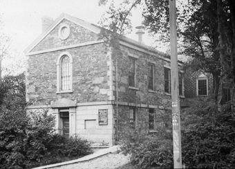
In 1824, the town voted to build a two story "Town House" to accommodate many functions including school, town meetings, religious services, temperance lectures, Lyceum lectures, and singing schools. In 1890, the First Parish Church purchased the building, which had been named Pierce Hall, thus incorporating both the building's function and physical structure into the church. The building was named after one of Brookline's most beloved citizens, Reverend John Pierce, who was the church's fifth pastor, serving from 1796 to 1849. He also served as chairman of the school committee for 50 years.
In 1844, a significant shift in the geography of Brookline occurred when a new town hall was built on Washington Street, north of Brookline Village, near its present site. This move shifted the center of Brookline north to Brookline Village, and was reinforced by the coming of the railroad to the Village in 1847.
Preserving the Reservoir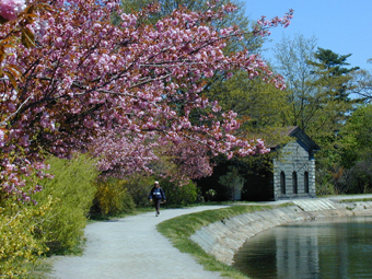
(Photo by Jean Stringham)
The Brookline Reservoir, located just west of the Town Green, was built in the late 1840's as part of the water system bringing water to the Beacon Hill Reservoir from Lake Cochituate. The 30-acre site was purchased for $58,419. The reservoir's fate hung in the balance when, in 1902, the City of Boston decided to sell it. The threat of development spurred the neighbors to action, and they contributed $50,000 towards the $150,000 needed to purchase the site. This group of concerned citizens included Amy Lowell, John C. Olmsted, Walter Channing, Edward Atkinson, and George Lee.
By the mid 1800's, development had spread outward from the Town Green area. Homes were built on the nearby streets of Chestnut, Walnut, Dudley, and Fairmont. Another wave of building at the turn of the 19th century brought homes in the prominent styles of that era, namely Colonial Revival, Queen Anne, and Shingle, which replaced homes of the colonial era.