Addington Path by Linda Olson Pehlke
Linda Olson Pehlke is an author and urban planner living in Brookline. Her book, Exploring the Paths of Brookline, is available at Brookline Booksmith and other locations. The series "In Step: Brookline's Paths" was published in Our Town Brookline magazine in 2005 and appears here with the permission of its publisher and the author.
Up Aspinwall Hill to Schick Park
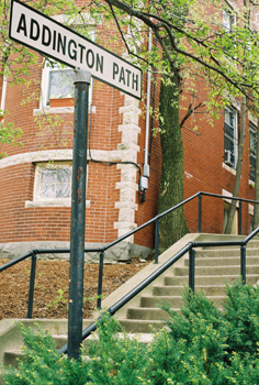
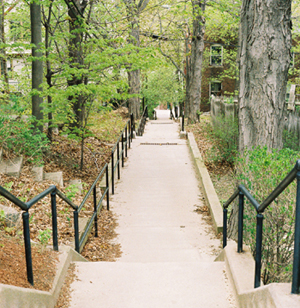
Ascending the north slope of Aspinwall Hill, Addington Path offers a direct route to the top, where Schick Park awaits. There is an interesting rhythm to the trip. The climb alternates between a short stack of stairs and an inclined but flat portion, and then back to a few more stairs. The surrounding landscape is an equally varied affair, with portions of the path feeling closed in by their proximity to neighboring buildings, only to have the borders broaden, exposing backyards with trees and shrubby undergrowth. Iron handrails frame both sides of the path. Halfway up, the steepness of the hillside and the challenges inherent in building on this terrain are revealed. Moss and vines engulf sturdy stone retaining walls and foundations. Their age and permanence disclose the determination and effort that went into building on the hillside.
The Aspinwall Family Arrives in 1650
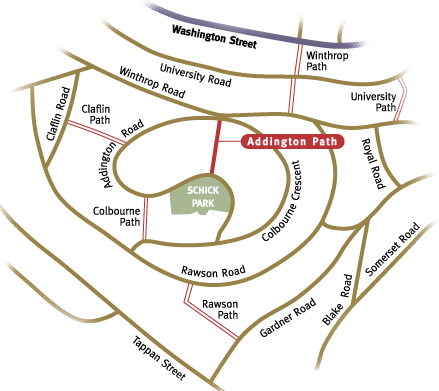
Addington is one of seven paths on Aspinwall Hill, and was accepted by the town in 1894. Designed by the Aspinwall Hill Land Co., the roadways, building lots, and paths formed the basic structure for residential development on the hill, which had begun in 1880. Many fine examples of Victorian era architecture still stand in the hill's neighborhoods. The Aspinwall family's local history began in 1650 when Peter Aspinwall purchased land near St. Paul and Aspinwall Avenue. His great-great grandson, Dr. William Aspinwall, bought 87 acres encompassing the hill. When he sold his land in 1880, the Aspinwall Hill Land Co. was formed. Dr. Aspinwall's eldest son, Thomas Aspinwall, a partner in the engineering firm that drew up the plan, had a particular interest in including the paths in the plans. Perhaps we have him to thank for the paths we enjoy today.
© 2010 Linda Olson Pehlke. All rights reserved. No part of this article may be reproduced in any form without prior written permission from the author.
Map by Robert Pehlke. Photographs by Linda Olson Pehlke