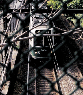
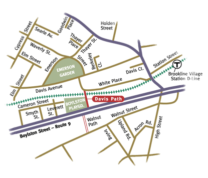
Climbing the massive stone and concrete steps of Davis Path, the traveler is safely carried up and over the D line train tracks. Viewed from above, the speed and mass of the trains are accentuated as they whoosh and rumble underfoot. Beginning on White Place and ending at Boylston Street across from Lincoln School, the path links the residential neighborhood west of Brookline Village with Boylston Street (Route 9). Once up and over the train tracks, Davis Path skirts the Boylston Playground, which is often filled with Lincoln School children and their infectious laughter. The green lushness of the playfield is a welcome contrast to the hard concrete and stone of the bridge. The scent of hyacinths perfumes the air, emanating from a planter bed at Boylston Street. A pedestrian crossing signal on Boylston Street allows foot traffic to cross the busy thoroughfare.
Named after the Davis family, who built their family home at the corner of Washington and Davis Streets in 1760, the path was at first named Walnut as it was considered an extension of the Walnut Path located nearby on the other side of Boylston Street. The name was changed to Davis Path in 1924.
Building the Stone BridgeGrand and monumental in scale, Davis Paths' substantial stone bridge was designed by J.R. Worcester & Co., consulting engineers. Davis is the only path that includes a bridge. Accepted by the town in 1911, it was a relatively late addition to the town's path system. While it is only 248 feet in length, the extensive construction made it the second most expensive path (Beaconsfield was the most expensive). Town expenditures included $3,500 for construction and $775 in land damages, which were paid for 1,284 square feet. The path also required a taking 4,980 square feet of land, and Boston and Albany railroad donated 780 square feet of land. Paying land damages in the process of building the paths was a rare occurrence. In most other cases, the small amounts of land needed for path construction were donated.
Proximity to Brookline Village meant that the path was being built near the commercial heart of early Brookline. In the 1840's White Place and the area to the east of the Village surrounding Linden Square were laid out in the compact and dense pattern characteristic of building of this era. Residential development continued to fan out from the heart of the Village, and was built in a variety of styles to house the burgeoning immigrant population.
Today, gently curving streets, mature trees, and lovely homes set in a human-scaled environment combine to make a pleasant pedestrian experience. Emerson Gardens, which is bordered by Davis Street, is a jewel of the neighborhood with its majestic mature trees, perennial plantings, and fountain. A summer series of free evening concerts are a popular and pleasant way to enjoy the park. Davis Path aids access to the park for the neighborhoods to the west and south of Brookline Village, as well as allowing easy passage to and from adjacent neighborhoods.