LAND OWNERSHIP IN BROOKLINE
From the First Settlement
ILLUSTRATED BY SIX MAPS
1636, 1667, 1693, 1746, 1786, 1822
By THEODORE F. JONES, Ph.D
1636, 1667, 1693, 1746, 1786, 1822
By THEODORE F. JONES, Ph.D
CONTINUED BY FOUR MAPS
1844, 1855, 1888, 1916
BY BROOKLINE SURVEYORS
1844, 1855, 1888, 1916
BY BROOKLINE SURVEYORS
WITH GENEALOGICAL ADDITIONS
By CHARLES F. WHITE
By CHARLES F. WHITE
PUBLICATION NUMBER FIVE OF THE
BROOKLINE HISTORICAL SOCIETY
1923
BROOKLINE HISTORICAL SOCIETY
1923
Forward
Of the series of maps of Brookline which follow, the first six and the descriptive text accompanying them come as a gift from a native of the town, Theodore F. Jones, Ph. D., Associate Professor of History at New York University and member of the Brookline Historical Society. Everyone having an interest in Brookline development is indebted to Mr. Jones for the results of his long labor of love in his profession. Acknowledgements are also due to Mr. George O. Yanosik, Instructor in Mathematics at the same university, who so clearly drafted the maps from Mr. Jones' sketches, and to Mr. W. Ogilvie Comstock, Jr., for the work of preparing titles and adding local geographic features from his experience with the Town Engineering Office. The time seemed opportune to supplement Mr. Jones' maps with four others, reproductions of the town maps of their respective dates, making the series cover the life of the town for 280 years.
The outstanding feature of interest is in the land boundaries of the successive owners, and the location of the residences in the maps of 1844 and 1855.
Property boundaries in part have been added to the map of 1888, from the town atlas of that year. The publication of a generous edition of these maps (750 copies) would have been beyond the reach of the society's treasury, had not the friends named below defrayed the extra cost of issue.
| Mrs. William D. Hunt, | Mr. Frederick Jones White, |
| Mr. Henry H. Richardson, | Dr. Randall Clifford, |
| Mr. James M. Codman, | Miss Susan E. White, |
| Mr. Walstein R. Chester, | Mrs. Henry Curtis, |
| Mr. Henry B. Cabot, | Miss Laura R. Little, |
| Mr. Ernest B. Dane, | Mr. Charles F. White, |
| Mr. Edward W. Atkinson, | Mr. Edward W. Baker, |
| Mr. Sherman L. Whipple, | Mr. Luther M. Merrill, |
| Mrs. John C. Olmsted, | MissesH.F.,M.A.,and G.G.White. |
Committee on Papers and Publications:
CHARLES F. WHITE,
CHARLES F. READ,
EDWARD W. BAKER, THE PRESIDENT, ex officio.
CHARLES F. WHITE,
CHARLES F. READ,
EDWARD W. BAKER, THE PRESIDENT, ex officio.
The present publication of the Brookline Historical Society gives to the town of Brookline what few other New England towns possess: an attempt to present in graphical form, by a chronological series of maps, a fairly complete history of the ownership of its land from the first settlement until about a century ago. In the strictest sense of the word, Brookline is not one of the oldest towns in the Commonwealth; but, although it was not incorporated as a township until 1705, its land, as a part of Boston, had been largely assigned to private owners before 1641, and the matter of the present study is as ancient as would be a similar attempt for Roxbury or Dorchester.
Some similar attempts have been made. F. Jackson's History of Newton (Boston, 1857) includes some very helpful maps. T. B. Wyman's History of Charlestown (2 vols., Boston, 1879), through its publication of almost every conveyance of land in that town, supplies the raw material for the historical cartography of Charlestown. Frank Smith's "Dover Farms" (Dover, 1914) embodies much research in the history of the land in that neighboring town, but does not attempt to record definite boundaries or to present the results in the form of maps. Miss A. H. Thwing's "The Crooked and Narrow Streets of the Town of Boston, 1630-1822" (Boston, 1920) gives a few good maps and summarizes the results of her unpublished "Inhabitants and Estates of the Town of Boston, 1630-1800", the manuscript of which, on over 125,000 cards, is in the Library of the Massachusetts Historical Society. The latter work traces the history of all recorded changes in the ownership of land in Boston until 1800, and should be published. No town save Brookline, I think, has its history recorded in the form now presented.1
The method of investigation was to begin, of course, with the boundaries of estates as given in the first general survey of boundaries in 1874, and thence, with the help of the first large-scale map of the town, that of E. F. Woodward of 1844, to trace the history of each parcel in the Registries of Deeds and of Probate of Norfolk County since 1793, and of Suffolk County before that date. In each case my desire was to establish a direct connection between the parcel of 1874 and a grant by the Town of Boston to the first owners of real estate in Muddy River, as recorded in the Town Records and in "The Book of Possessions."2 In most cases I have, I think, succeeded. I was, of course, greatly helped by the surveys of separate parcels, dated earlier than 1874, recorded in the Registries. Since about 1850 such maps are common. Before 1800 there are scarcely any such maps, and the earliest is that of 1696 in the conveyance of three acres by the heirs of Jacob[1] Eliot to Samuel[2] Clark, and of eight acres to Roger Adams (recorded in Suffolk Deeds, Lib. 17, f. 757), and is, unfortunately, in the Marshes and of very little help. After 1696 there is scarcely a single map recorded until the series filed by George[4] Cabot for his various sales in the year 1803.
Boundaries which are only approximate are given in dotted instead of continuous lines. And finally I must confess that bounds in the region of Longwood and along the Charles River, until the early small holdings pass into the hands of two families, the Sewalls and the Aspinwalls, are indefinite and unsatisfactory.
An attempt has been made, based upon the Boston and Brookline Town Records, to give in the matter of roads on each map only those surveyed by the town at the respective date.
I owe a debt of peculiar gratitude to Mr. Charles F. White, both for his earlier work along lines similar to my own,3 and for his encouragement and advice whenever I turned to him.
MAP No. 1. MUDDY RIVER: ALLOTMENTS BY THE TOWN OF BOSTON, 1636-41
This map is based entirely on the notices of allotments at Muddy River entered in the Boston Town Records. The first of these allotments is that of Dec. 14, 1635: "It is agreed that . . . five men . . . shall lay out at Muddy River a ... farm for our teacher, Mr. John[1] Cotton." The latest allotment I have found recorded, save for a few minor ones in the Marshes, is that of May 31, 1641: "Our brother Robert[1] Turner is granted that land which lieth between his lot and Cambridge new line, so far as the limits of his lot reacheth it." I have included one estate which is not found in the allotments, Jane[1] Parker's forty acres (at the beginning of Heath Street), entered on page 80 of the "Book of Possessions." The larger portion of the holdings at this early date are based upon the "Great Allotment" of Jan. 8, 1637-8, the beginning, of course, of all studies in the history of land in Brookline.
The most conspicuous of these early grants are the following: (1) William[1] Tyng's 600 acres in the southwest; (2) William[1] Hibbins' 300 acres in the northwest; (3) Griffith[1] Bowen's 150 acres on the later Newton Street; (4) Thomas[1] Oliver's 160 acres, (5) Thomas[1] Leverett's 175 acres (these last two tapering to a point at the Village); (6) Rev. John[1] Cotton's 250 acres,, between the two brooks; and (7) William[1] Coleborne's 150 acres.
Considerable ingenuity has been used by earlier investigators in tracing the northwest boundary of the Cotton allotment, which is thus described: "all the ground . . . between the two brooks, next unto Mr. Coleborn's allotment, and so to the other end unto the shortest cutting over beyond the hill toward the northwest, containing 250 acres, bounded ... on the west by John[1] Cramme [sic] and George[1] Bates." Earlier investigators have placed the boundary considerably to the south of mine; I believe, however, that mine is correct. John[1] Cramme must be a misprint for John[1] Cranwell; Cramme (or Cranny) has his allotment along the Muddy River, and John[1] Cranwell receives ten acres, "bounded on the southeast with Mr. John[1] Cotton." The Cranwell allotment passes through the hands of Thomas Marett (1652) to Jacob[1] Eliot; from him to John[2] Ackers in 1667; from him to Joshua[2] Scottow; and in 1669 to John[1] White,4 still bounded on the east by the Cotton land. It is easy to trace the later history of John[1] White's purchase, and its southeast line must be the northwest bound of the Cotton allotment.
The boundaries of the smaller allotments northeast of the Coleborne grant are confused and difficult; of the strip to the northwest of the later Harvard Street, I am confident of only one, that of James[1] Davis. The six grants, to Townsend, Wilson, Salter, Purton, and Bulgar, are smaller on my map than the acreage demands, but I think that the original survey must have been defective. The limits of the small allotments which partly encircle the "Cedar Swamp" were soon to be obliterated, and my results are probably far from accurate. Slight alterations in the shore line of the Charles River would demand many changes.
MAP No. 2. MUDDY RIVER IN 1667
The second map in the series shows the changes produced by the lapse of a generation. Its results may be checked with the tax-list for Muddy River in 1674, published in volume 1 of the Reports of the Boston Record Commission.
Its most striking feature is the practical disappearance of the "absentee landlords," the Leveretts, the Olivers, the Hibbinses, the Colebornes, etc., the great men of Boston, who lived in town and probably rented their holdings in Muddy River. There are two exceptions to this rule. For another sixty years the heirs of Rev. John[1] Cotton cling to their grandfather's allotment. Settled as ministers at Hampton, Plymouth, Yarmouth, or Sandwich, they rent their Brookline lands to tenant farmers, such as James Pemberton of 1667. The heirs of Jacob[1] Eliot, also, do not sell until the end of the century.
Note, however, that in 1656, the heirs of William[1] Tyng have sold his six hundred acres to Thomas[1] Hammond and Vincent[1] Druce. The division between the two partners mentioned in Jackson's History of Newton (p. 298) I have not found recorded; but from their wills it is not hard to reconstruct.
William[1] Hibbins, one of the Assistants of the Colony, died in 1654, and later in the same year his widow Ann (Belling-ham) Hibbins was put to death for witchcraft. Her executor sold her estate at Muddy River, "Stamford Farm," of 350 acres, to Isaac[1] Stedman in 1657. Her husband had also bought, before his death, the allotments of Captain John[1] Underhill and Robert Mears (120 acres around modern Cottage Street), and her executor sold in the same year this property "Ronton Farm" to John[1] Winchester. This is the first appearance of the Winchesters as landowners in Brookline. North of John[1] Winchester, Joseph[2] Buckminster has inherited from his father Thomas[1] (died 1656) a farm of seventy-two acres, later to be largely the property of the Boylstons.
Thomas[1] Leverett, at his death in 1650, left his house and 175 acres in Muddy River to his widow Ann (Suffolk Probate, 2-25). At her death in 1657 "all her land in Muddy River," not inventoried, passed to her son, Sir John[2] Leverett. I find no further mention of the Leveretts as landowners. Sir John[2] died in 1679, but his estate was not inventoried; it is entirely clear, however, that before 1674 his land in Muddy River was already occupied by Thomas[2] Gardner, who was the largest taxpayer in the village in that year, while the Leveretts paid no taxes at all.
When the title passed from Leverett to Gardner I do not know; no court record was made. But the large estate of Thomas[2] Gardner, Sr., could have come from no other source, except for the small allotments of Blackstone, Tytus, and Courser (at Fisher Hill), the records of the purchase of which by Gardner exist, and for the Alexander[1] Winchester allotment, north of Courser, which his son, Andrew[3] Gardner, apparently bought for himself. If further evidence is desired of the passing of the Leverett lands to Thomas[2] Gardner, be it noted that in 1717 the estate of Caleb[4] Gardner, died in 1716 (Joshua3, Thomas2), sold to Thomas Jepherson "a parcel from the east end of the land late of Caleb[4] Gardner, formerly called Leverett's farm." This small parcel of only five and one-quarter acres was bought in 1722 by Edward[3] White, and may be easily identified on my map of Brookline in 1746.
As early as 1650 the whole estate of Thomas Oliver,5 to the south of Leverett's farm and coming to a point with the latter, had apparently been sold to John[1] White.
The Oliver farm was of about 150 to 160 acres; and it may be easily calculated from the inventories of two of John[1] White's children, Lieutenant John[2] and Benjamin[2] White, that their father had given them together about 160 acres located precisely where the Oliver allotment had been. No record of the sale was made in the Suffolk registry. From the "White Papers," however, published by the Brookline Historical Society in 1897, it appears that in that year there still existed a deed of sale of fifty (sic) acres of upland and six of fresh marsh by Thomas Oliver to John[1] White in the year 1650. That deed cannot at present be discovered; but through a manuscript note belonging to Mr. C. F. White, it appears that the Rev. John Pierce saw the deed before 1828 and that it was for 150 acres. Note also that before 1667 John[1] White has bought the Cranwell allotment on the northeast side of the Cotton grant.
In 1650 William[1] Coleborne sold his 150 acres north of the brook to Robert[1] Sharp and Peter[1] Aspinwall. I have found no record of the division, but, as in the case of the Hammond-Druce partnership, it is not difficult to reconstruct the division. Peter[1] Aspinwall's will (1692) and a careful study of Sharp land make me confident that my map for the division, as it existed in 1667, is accurate. By 1667 Robert[1] Sharp (died 1656) had been succeeded by his son, John[2] Sharp.
Edward[1] Devotion6 has from many sources secured a large farm on both sides of the road to Cambridge; but, it would seem, he is still the tenant of the heirs of Jacob[1] Eliot for a good part of his holdings and not yet the owner.
The future Longwood is still owned in small parcels, grouped around the "Cedar Swamp," which had been rented by the town to Ralph Mason in 1658 for a long term of years. Joshua[2] Scottow, however, has already gathered a good number of the former small parcels in the northern section into a group soon to become the nucleus of the great Hull farm.
By 1667, then Muddy River already was largely owned by such families as the Stedmans, Druces, Winchesters, Buck-minsters, Gardners, Whites, Sharps, Aspinwalls, and Devotions, whose history is the history of Brookline in the eighteenth century.
MAP No. 3. MUDDY RIVER IN 1693
The selection of the year 1693 for the third map is due to the existence of a tax-list for that year, which can be compared with a valuation list for 1687, both published in volume 1 of the Reports of the Boston Record Commissioners.
Again the reader will note the continued existence in the Cotton family of the title to John[1] Cotton's grant. In 1693 the Cotton farm was rented to Roger Adams,7 who has also purchased the title to the former Kibby farm on the Water-town Road, next to the Cambridge line.
The Aspinwall share in the Coleborne farm remains unchanged, but is now in the hands of Samuel[2] Aspinwall (died 1727). The Sharp share is also the same, but since the death of John[2] Sharp at Sudbury fight in 1676, the part of the farm in Longwood has belonged to his younger son, William[3] Sharp (soon to settle in Pomfret, Conn.), while the part to the northwest has been for the moment divided among the heirs of his oldest son, Robert[3] Sharp, who died on the Canadian expedition in 1690.
Edward[1] Devotion died in 1685, and his farm, surely including the lease of the Eliot property, is in the hands of his heirs, who have perhaps already assigned all their interest to his oldest son, John[2] Devotion. He is supposed to have built his house in 1680, but it appears to me to have been built on land that was not sold by the heirs of Jacob[1] Eliot to John[2] Devotion until 1698.
Since 1667 John[2] Hull has acquired over 300 acres in Muddy River, largely by purchase8 from Joshua[2] Scottow, Manasses Beck, Ralph Mason, and others, but about thirty-eight acres (near the present Chestnut Hill Reservoir) by inheritance from his father Robert[1] (died 1657). Hull died in 1683, and in March 1684 it was agreed that at his widow's death his lands should be divided among his Sewall grandchildren. His lands lay in three divisions: (a) his Brookline farm (whence the town was to take its name), leased by Simon Gates; (b) his swamp lands, occupied by George Barstow (probably around the Cedar Swamp, which he had bought in 1677 from Ralph Mason); and (c) his Hogscott lands (at the new Reservoir), occupied by Andrew Gardner. It is apparent that the "Hogscott" lands soon were sold to John Devotion, although no record exists; in 1706-1718 Devotion surely sells them to others.
A family which was later to be a large land holder on Walnut Street is in 1693 located on the Cambridge Road. Before 1674 James Clark had bought land near the present Coolidge Corner and in some way (not recorded) had secured a house lot on Sharp land, running down to the brook, west of the Cambridge Road. In 1693 these two parcels went to his son Samuel[2] Clark (1654-1728).
On Thomas[2] Gardner's death in 1689, his great Leverett farm was divided among his three sons, Andrew3, Thomas3, and Joshua3, and his son-in-law, Thomas[2] Boylston, as the map shows. Thomas[2] Boylston has purchased two other parcels, to the west, off the Sherborn Road, and another of the prominent families of later Brookline has thus secured a foothold, through connection with the Gardners.
On John[1] White's death in 1691 the Oliver farm was divided between his sons, Benjamin[2], who got the eastern end, and Lieutenant John[2], who got the western. His other son, Joseph[2], had been provided for, as early as 1673, by the purchase from the heirs of the Isaac Grosse allotment, beyond Andrew[3] Gardner on the Sherborn Road; and all three sons received shares in the lot on the Eliot trail to Newton, bought of Ralph Mason in 1670. Farther south on the same road, the thirty-two acres bought of Joshua[2] Scottow in 1674 (allotted to William Hudson in 1638) were entailed by John[1] White's will to be used as an orchard for supporting his sons' eldest sons in college for seven years.9
Joseph[3] Buckminster still keeps his father Joseph's heritage, but has just purchased, in 1692 (Suff. Deeds, 31-78), from Uriah[2] Clark sixty acres southeast of the present Clyde Street, which were apparently still the property of the Town of Boston in 1667; in some way he had also secured the land south of John[1] Winchester's, where Cottage Street now passes into Rox-bury, the earlier history of which is to me obscure,10 in spite of a tradition that this was the earliest home of the Buckminsters.
John[1] Winchester is still alive in 1693, but a thirty-acre house lot from the north of "Ronton farm" has since 1681 belonged to Jonathan[2] Torrey.
John[2] Winchester, Jr., has begun to buy land in the north and by purchase from his father-in-law, Henry[1] Stephens, has laid the beginnings of two big farms, one on the Cambridge Road and one on the Watertown Road.
On the death of Griffith[1] Bowen in England in 1676, his great allotment of 150 acres was divided among his heirs, one of whom was his daughter Mary[2], wife of Benjamin[1] Child; and it would appear that her son Joshua[2] Child (1658-1729), as early as 1693, had control of the whole Bowen lot, all of which ultimately passed to his ownership.
The Hibbins-Stedman farm is still in the hands of the Stedmans, but has been divided between Isaac[1] Stedman's son Thomas[2] and his grandson Nathaniel[3].
By the will of Thomas[1] Hammond (1675), 200 acres of his Tyng purchase were divided between his daughter, Elizabeth[2] Woodward, and his two grand-daughters, Sarah, wife of James Herring, and Elizabeth, wife of Abraham[2] Chamberlain. In 1693 (Suffolk, 29-138) the share of Elizabeth[2] Woodward, in two parcels, has gone to her son, George[2] Woodward, as the map will show. In 1687 Sarah Herring had sold her shares to Joseph[2] Griffen, and he, in turn, had sold the northern half to John[2] Davis. The other 100 acres belonging to Thomas[1] Hammond have gone to his sons.
A portion of the Vincent[1] Druce farm has been sold by his heirs to his son's widow's second husband, Erosamond[1] Drew, proprietor of the famous sawmill.
MAP No. 4. MUDDY RIVER IN 1746
For the year 1746 a tax-list has survived and gives a good foundation for an accurate map of Brookline in that year. The passing of more than fifty years since the period of the third map had produced many changes.
The old Hull farm, slightly enlarged by purchases from John[2] Devotion of fifteen acres in 1706, is now in the hands of Judge Samuel[2] Sewall's grandson, Henry[4] Sewall (Harvard College, 1738), who has recently married Ann[4] White, daughter of Samuel[3] White, J. P., of whom more will be said later. His nearest neighbor to the north is Solomon Hill, who had bought Edward[2] Devotion's farm of seventy-six acres in 1740, when the latter left his paternal acres and lived his four remaining years in a house in the Village. To the southeast of Henry[4] Sewall, the Aspinwall farm has been considerably changed. Samuel[2] Aspinwall (died 1727), and his son, the present owner, Thomas[3] Aspinwall (died 1774), have sold their old Coleborne lands on the upper Watertown Road (Washington Street), but in compensation have bought out the five or six last survivals of the old small allotments to the east of the Cedar Swamp. Thomas[3] Aspinwall, therefore, now owns a farm of over 130 acres which extends along Muddy River from the Cotton brook, northeast across the "road to the marshes."
Captain Robert[4] Sharp (1688-1765) has more than restored the somewhat shattered fortunes of the family. He is the first of the family to live to a reasonably old age (his father died in Canada in 1690, and his grandfather was killed in King Philip's war in 1676), and had, it seems, a desire to increase the family estate. As early as 1729 he purchased the twenty-six acres of the estate of Samuel[3] Clark (just southeast of Coolidge Corner); and although he at once resold the northeastern half to William Gleason, the other thirteen acres remained as the Sharp orchard until 1821, when it passed to Charles[8] Stearns. In 1731 he bought from Nathaniel[4] Cotton the long narrow strip of land between the brook and the Watertown road; and sometime before 1740 he bought the northernmost twenty acres of the old Cotton farm.11 His son, Robert[5] Sharp (1715-67), had recently received from his father a fifteen-acre house lot just north of the school-house lane, where previously his great uncle, William[3] Sharp, had lived before he moved to Pomfret, and where later his son, Squire Stephen[6] Sharp, was to live until his death in 1821. Robert[6] Sharp, Jr., also occupies the former Clark orchard spoken of above.
Meanwhile the Winchesters, whose land was formerly largely in the south of the town, have moved mostly to the north, and the head of the family, Captain John[3] Winchester (1676-1751), now owns one of the biggest farms in Brookline, including all the land on the left of Harvard Street, from the Sharp bounds to the Cambridge line and extending west over the "Great Hill," and reaching the Watertown Road in two places. It will be noticed that they had bought land of the Devotions, of the Aspinwalls, and most of the old Roger Adams lot on the Cambridge line. His son, Isaac[4] Winchester (1712-71), has taken over his father's sixty-acre farm on the other side of the Watertown Road.
At last the Cottons have relinquished all their Brookline land, which has passed principally to three new owners. (1) In the south Thomas[4] (John[3], Seaborn[2], John[1]) Cotton of Pomfret, late of Brookline, has sold in 1740 (Suffolk, 78-35) to Ebenezer[3] Davis (1703-1775) eighty-five acres, extending from Muddy River north between the two brooks as far as the School Lane and Cypress Street (the "New Lane")i which had been laid out in 1720. (2) Between 1727 and 1732, about eighty acres of Cotton land north of Cypress Street have come into the possession, either by purchase directly from heirs of John Cotton, or, indirectly, through Richard[4] Gardner, of Samuel[4] Croft (1701-1777), who as early as 1726 had leased, in partnership with James Shed, 182 acres of the Cotton farm. Samuel[4] Croft, and his son, Samuel[5] Croft (1751-1814), both married daughters of their neighbors across the brook, the Sharps, and the two properties were at last (in 1821) merged. (3) North of the Croft purchase, most of the remaining Cotton land, about eighty acres, had been sold between 1735 and 1740 to Major Edward[3] White (1693-1769), who had inherited from his father, Ensign Benjamin[2] White (died 1723), the ten acres of the Cranwell allotment north of the Cotton land, and twenty-nine acres of the Pell allotment just across the Watertown Road, to which he had added in 1724 fifteen acres of the Coleborne allotment, bought from Samuel[2] Aspinwall. Upper Washington Street was becoming largely the property of two families, the Whites and the Winchesters. To be sure, in the sale of Cotton land, Robert[4] Sharp apparently bought the twenty most northern acres before 1740, as noted before, although no record was made. Two brothers, Caleb[3] and Thomas[3] Dana, had also bought five acres apiece of Cotton land.
The same Major Edward[3] White had also inherited the eastern half of the Oliver purchase, and, as noted before, had crossed Walnut Street and bought the lower end of the Gardner-Leverett Farm. His father Benjamin[2] White had, as early as 1717, sold a small lot of land at the entrance to the village, on the right, to James[3] Goddard for a Tavern (Suffolk Deeds, 37-183). This is the origin of the "Punch Bowl Tavern," which in 1746 belonged to John Ellis.
The western end of the Oliver allotment, the share of Lieut. John[2] White, had been divided among the heirs of John[2] White in 1702 (Suffolk Probate, 15-128); and most of the heirs had sold their share in 1713 to an Isaac Bisson, who soon sold his sixty-six acres to Josiah[3] Winchester, Jr., (1681-1724) and Samuel[3] Clark, Jr.,12 who divided the property, Clark getting the eastern and larger share. Thus originates the long-lived Clark farm on Walnut Street.
The great farm on Cottage and Warren streets which belonged to Capt. John[1] Winchester in 1693 had gone to his younger son, Josiah[2] Winchester (1655-1728), at his death in 1694, the elder son, John[2] Winchester, 1643-1718, taking the property on the road to Cambridge, as we have seen before. Before his own death Josiah[2] Winchester apparently transferred the eastern part of this estate to his son, Josiah[3] Winchester (1681-1724), who in 1717 partitioned Lieut. John[2] White's farm with Samuel[3] Clark (see above); and the western half of Josiah[2] Winchester's farm went to his sons, Amariah[3] Winchester (born 1688) and Elhanan[3] (born 1692). Amariah[3] sold his forty acres to Samuel[3] White about 1734; and about the same year Josiah's[3] property was sold by his son, Caleb[4] Winchester (born in 1709), who now moved to Marlboro, to John[4] Seaver (1699-1767), whose elder brother Nathaniel[4] was living on the old Andrew[3] Gardner farm. Then between 1735 and 1746, the younger brother of Deacon Ebenezer[3] Davis, Nehemiah[3] Davis (1707-85), brought together again most of the old John[1] Winchester farm by buying from Samuel[3] White, Amariah[3] Winchester's share, from John[4] Seaver a large part of Josiah[3] Jr.,'s share, and from Elhanan[3] Winchester his own share (cf. Suffolk Deeds, 71-197 ff.), until he had an estate of about ninety acres. It is this Nehemiah[3] Davis, of course, who built the Cabot-Goddard house on Warren Street.13
About ten acres of John[4] Seaver's land on either side of Warren Street were not bought by Nehemiah[3] Davis, as may be seen on the map of 1746, but passed about 1760 to Jeremiah Gridley (Suffolk Deeds, 94-176). In 1705 Henry[3] Winchester (John2, John1), younger brother of the Capt, John[3] Winchester of Harvard Street, bought from John[2] Devotion (Suffolk Deeds, 45-214) a farm of forty-eight acres, twenty-eight in Brookline, twenty across the line in Roxbury, the Brookline part of which had in 1693 belonged to Joseph[3] Buckminster. It seems evident, as well, that the thirteen acres bought by John Winchester of Frances[3] White, wife of Benjamin Goodwin in 1711, her share in the property of her father, Lieut. John[2] White (died 1695), must have gone to his son, Henry[3] Winchester, although I find no record of this; observe on the map of 1746, the triangular eastern end of Henry[3] Winchester's farm, which is unmistakably formerly part of the Oliver-White purchase.
In 1699 Dorman[1] Marean had secured the thirty-two acres of land west of the Winchester farm, and adjoining the eighteen acres to the west that he already owned in 1693. In 1711 this same Marean got the southwestern share in the great division made of Common Land in the west by ten inhabitants of Brookline. These two parcels were purchased in 1712 by Joseph[2] Goddard, formerly of Watertown (Suffolk Deeds, 27-68) and in 1746 are held by John[3] Goddard, Joseph's son.
Let us now turn to the Leverett-Gardner property. The lower end of the farm, which belonged to Joshua[3] Gardner (1659-1700) in 1693, has been sold by the latter's heirs, between 1726 and 1732, to the Rev. James Allen (1691-1747), the first minister of the Brookline Church. He died in 1747, and his estate of forty acres passed to his daughter Mary, who, it is well known, was engaged to marry the Rev. Cotton Brown, her father's successor. She died in 1750, before marriage, but bequeathed her land to Mr. Brown, who himself died the next year. Most of the property was sold in 1757 to Henry[4] Sewall.
The central part of the Gardner farm, the property of Lieut. Thomas[3] Gardner in 1693, had belonged since 1743 to his youngest son, Benjamin[4] Gardner (1698-1762, see Suffolk Deeds, 156-190), except about twelve acres, at the present site of the First Parish Church, where Benjamin's elder brother Nathaniel4, a Boston merchant, had built a house. Nathaniel[4] Gardner had died before 1746, and in that very year his heirs14 sold his dozen acres to Joseph[4] and Moses[4] White, who apparently conveyed the land shortly after to Jeremy Gridley, 15 the well-known Boston lawyer. Thus reappears in Brookline the Boston gentry, which had left the town a century before. Benjamin's[4] brother, Caleb[4] Gardner, had given the town the land for the church in 1717.
The farm which Thomas[1] Boylston got from his father-in-law has been much enlarged, especially by the purchase of ten acres south of the highway, where the old Reservoir lies today. The property is now in the hands of Dr. Zabdiel[3] Boylston (died 1766), the celebrated physician. His younger brother, Dudley[3] Boylston (died 1748), has settled on the farm across the brook to the south which belonged in 1693 to Joseph[3] Buckminster.
The great farm which belonged to Andrew[3] Gardner in 1693 was after his death in 1694 divided among his heirs. By 1706 the eastern half had been secured by his son-in-law, John[3] Seaver, and now in 1746 was owned by the latter's son Nathaniel[4] Seaver (1697-1768). The western half was purchased indirectly by Andrew[3] Gardner's nephew, Isaac[4] Gardner (1684-1767), who has also purchased a good deal of the Sewall land at "Hogscott," and become one of the richest farmers in Brookline. To the southwest of Isaac[4] Gardner, his nearest neighbor is William[4] Ackers (1719-94), whose father, John[3] Ackers, secured his farm before 1700 by three separate purchases.16 Ackers also has a big pasture at the corner of Clyde and Warren Streets, bought from Peter Gardner in 1724.
One of the two or three most prominent men of Brookline in 1746 is Esquire Samuel[3] White, J. P. (1682-1760, Joseph[2], John[1]), Major Edward[3] White's first cousin. From his father Joseph[2] (died 1725) he has inherited the homestead on Heath Street, between Pound Lane and Chestnut Hill Avenue, which he has enlarged by purchase of Buckminster land to the south; and from his father he also inherited the greater part of the "Mason lot" to the north, and fourteen acres on Clyde Street, laid out in 1715. By purchase he has also acquired large holdings in the west of the town, primarily (a) sixty acres southwest from Heath Street, most of which belonged to the Jacob[1] Eliot heirs in 1693, and (b) sixty-seven acres on South Street, partly bought from the heirs of George[2] Woodward, but largely given to Samuel[3] White by his father-in-law, Erosamond[1] Drew, who, as we have seen before, had acquired much of the Druce purchase. From Drew, also, Samuel[3] White had inherited considerable land on Newton Street, near the town line across the road from the Saw Mill.
Near neighbors to Samuel[3] White are his three nephews, Joseph4, Moses4, and Benjamin[4] White, sons of his brother Benjamin[3], who is still alive in 1746, but has handed over most of his property to his sons. Moses[4] White has a big farm on the present Reservoir Lane; his brother Benjamin[4] owns both sides of the middle part of Heath Street; and Joseph4holds the greater part of the later Thomas H.[4] Perkins estate, fronting on Woodward's Lane (Warren Street).
A good part of the land on both sides of Clyde Street has been acquired by different members of the Woodward family; but this subject has been well treated by C. F. White, and reference can be made to his article.17
The old Griffith[1] Bowen property is now divided between his two great-grandchildren, Joshua[3] Child (1687-1756) and Isaac[3] Child (1688-1765).
Note that the big area northeast of Newton Street, 120 acres, still belonging to the Town of Boston in 1693, has now been divided into a dozen small parcels, privately owned. The Town of Boston kept the title after the incorporation of Brookline; but sold the land to ten men of Brookline in 171l,18 in one of the most interesting and obscure transactions to study in the history of the town. I think that the bounds of the region in 1746, as given on the map, are accurate; but the titles are not clear to me in every case.
In the northwest the most noticeable feature is the breakup of the Stedman farm. One member of the family, Nathaniel[4] Stedman (Caleb[3], Thomas[2], Isaac[1]) still lives in Brookline, and owns 80 acres of his family land; but even these are sold to Benjamin[4] White (1707-77) in 1751. Benjamin[4] Gardner (1698-1762), whom we have already studied as the owner of his "lower farm" near the Church, has also acquired a good size "upper farm" on former Stedman property, as has also Ebenezer Sergeant. But most of the Stedman land is held in long and narrow strips of woodlot by various Brookline families. Particular interest attaches to one of these wood-lots, that just south of Heath Street near the town line, marked on the map of 1746 "late Edward[2] Devotion"; these are the thirteen and one-half acres of woodland bequeathed to the town by the will of Edward[2] Devotion to endow the Town School. They were sold by the town in 1759 to Ebenezer[3] and Nehemiah[3] Davis (Suffolk Deeds, 92-232).
Notice that John[3] Druce (John[2], Vincent[1]) still owns 100 acres on both sides of Newton Street; but the Druce property to the south has gone, mostly to James[3] Griggs, but partly to inhabitants of Roxbury, like Joshua Cheever and Daniel[4] Weld. Abraham8, son of George[2] Woodward, still keeps part of his father's property.
MAP No. 5. MUDDY RIVER IN 1786
A tax-list for September, 1785, is preserved in the handwriting of Stephen[6] Sharp, the town clerk, and signed by the assessors, John[4] Goddard, Daniel[4] Dana, Thomas[4] Aspinwall, Isaac Sparhawk[6] Gardner, and Ebenezer[5] Davis It is a useful guide to my map for that year. Several interesting changes in ownership have occurred since 1746, but the boundaries are strikingly unchanged. For the first time I have attempted, with many misgivings, to show the ownership of the marshes; the changes in ownership there are very hard to follow.
Henry[4] Sewall died in 1771, and two of his sons, Hull[5] Sewall, (H. C. 1761) and Henry[6] Sewall (H. C. 1768), at about the same time. The two Sewall farms (for note that in 1757 Henry[4] Sewall had purchased most of the Rev1. James Allen's houselot at the corner of Walnut and Cypress streets and gone there to live)9 were then divided between his son Samuel[6] (H. C. 1761) and his daughter Hannah[5], wife of E. K. Wolcott (c.f. Suffolk Probate, Lib. 84, f. 292) 20; and in 1760 Samuel[5] Sewall had already inherited more than half of his grandfather Samuel[3] White's property (Suf. Prob., 56-426 and 57-22), including over 180 acres, mostly on Heath Street. Samuel6 Sewall was a Loyalist refugee; and in 1782 the State of Massachusetts, having declared all his lands confiscated, sold his White inheritance to John6 Heath. In 1783 his share in his Sewall inheritance was sold by the State to his sister's husband, E. K. Wolcott. The Wolcotts continued to live on the Allen place until about 1790, and rented the Sewall farm, of 313 acres, to various tenants. 21
Solomon Hill had mortgaged the Devotion farm of seventy-six acres to Nathaniel Wheelwright of Boston in 1762; Wheelwright had foreclosed, and now, in 1786, his estate, also bankrupt, was sold by the attorney for his creditors, Francis Johonnot, to William Marshall, who in 1783 had already bought forty acres across the road, which James[5] Winchester had inherited as his share in the estate of his father, Isaac[4] Winchester, in 1771.
Northeast of this latter estate was the twenty-eight-acre farm of Joshua[5] Griggs, inherited from his father, Thomas[4] Griggs, formerly of Roxbury (died in 1782), and bought by the latter from Nathan[4] Winchester, who got it in 1752 from the estate of his father, Capt. John[3] Winchester. Most of the latter's estate went to his second son, Isaac[4] Winchester (1712-71); after Isaac's death, his estate was sold; the northwestern part, on Washington Street, was bought by John Wyman (who owns thirty-seven acres north of the Great Hill in 1786), and the southeastern half to the same Thomas[4] Griggs, who sold this estate in 1782 to his son Samuel[5], who holds it in 1786.
At the death of Robert[5] Sharp in 1767, the family estate was again divided. His widow, Sarah Payson (who had inherited a large estate in Roxbury from her father, Jacob Payson, died 1722) kept her thirds until 1791; but after the death of the second son, Jacob[6] Sharp, in 1775, the farm was divided between the eldest son, Robert" Sharp, (1743-98) and the youngest, Stephen[6] Sharp, J. P. (1749-1820), for many years town clerk of Brookline and school teacher. Stephen[6] had the old William[3] Sharp homestead on School Street, where he built a house, the Clark orchard, and also the lot on Washington Street next to the White land. Robert[6] Sharp had the rest of the farm until his death in 1798.
Their first cousin, Samuel[5] Croft (1751-1814), who has also married their sister, Susanna[6] Sharp (1751-1821), has recently inherited his father's big farm, across the brook from the Sharps, and in this very year, 1786, has added to it by buying the eight acres of the former Allen place which the Sewalls did not purchase.
Before his death Lieut. Thomas[3] Aspinwall had given his eldest son, Col. Thomas[4] Aspinwall (1734-99), the northern half of his farm, and the latter had built a new house on the Road to the Marshes. At his death in 1774 the rest of Thomas[3] Aspinwall's estate passed to his son, the well-known Dr. William[4] Aspinwall (1743-1823, H. C. 17(4), who in 1786 still lived in the old Aspinwall house.
After the death of Deacon Ebenezer[3] Davis in 1775, his big farm, at the lower end of the Cotton allotment, was divided between his two grandsons, Ebenezer[5] Davis (1759-1806), who married another sister of Stephen[6] Sharp, Lucy[6] Sharp, and Benjamin[5] Davis (1765-1807), son of Benjamin[4] Davis (1735-74). Benjamin[5] got the land west of Washington Street, which now stretched through to Walnut Street, by a purchase from the heirs of Mary Allen (see Suffolk Deeds, 116-153); and Ebenezer[5] inherited the rest, down to Muddy River. At the triangle where Harvard and Washington Street come together Jonathan[4] Dana keeps a tavern.
At the death of Major Edward[3] White in 1769, his son, the Hon. Benjamin[4] White (1724-90, H. C. 1744), a member of the Governor's Council, inherited his two estates, that at the village and that on both sides of upper Washington Street. Mr. White, however, is not prospering and his estate is mortgaged; at his death in 1790 the estate will be insolvent.
Beyond the White estate on Washington Street, Isaac[4] Winchester's sixty-acre farm, on the left of the street along the Cambridge line, has been bought in 1784 by Capt. Timothy[5] Corey, recently arrived from Weston.
Let us continue up the Sherborn Road (Walnut Street). Beyond the White estate the Clark farm, unchanged since 1746, is in the hands of Samuel[5] Clark (Samuel[4], Samuel[3], John[2], James[1], 1753-1814), who has recently married another sister of Robert[6]" and Stephen[6]" Sharp. Beyond the Clarks and the Church (at that time still on the north side of Walnut Street on former Gardner land), the homestead of Jeremiah Gridley (bought from Joseph[4] and Moses[4] White in 1746) had passed about 1770 to Henry Hulton of Boston, one of the mandamus councilors of the Province appointed by the Crown; who made this his country house. With the Gridley estate there also came to Hulton John[4] Seaver's ten acres on either side of Warren Street and eight acres on Cypress Street; he also bought from Samuel Park et al. the Rev. James Allen's ten acres in the "Saw Mill woods," in the extreme northwest of the town (Suff. Deeds, 120-44). Henry Hulton was, of course, a Loyalist refugee, and in 1781 the Commonwealth sold his confiscated estates in Brookline to David Cook, who in 1785 sold the homestead at the Church and the land on Warren Street to John Lucas. The eight acres on Cypress Street passed to Samuel[4] Croft and the Saw Mill woods to Caleb[5] Crafts.
Benjamin[3] Gardner's farm, beyond the Church, belongs to his son, Elisha[4] Gardner (1726-97) in 1786; but in this very year he sells his fifty-four acres on both sides of the road to John[3] Goddard (1730-1816), who now moved here with his younger son, Benjamin[4] Goddard, while his second son, Joseph[4] Goddard (1761-1846), remained on the old farm on the present Goddard Avenue.
In 1766 the whole Boylston farm, sixty-seven acres on both sides of the road (including the present reservoir) passed to William Hyslop, who was of Scotch birth. Since Dudley[2] Boylston's death in 1748, his farm on Warren Street has belonged to his son, Joshua[3] Boylston (1725-1804), who has, late in life, just married Abigail Baker.
Nehemiah[3] Davis (1707-85) has been dead a year, but his big farm is still in the hands of his executors, not to be sold until 1793 to George Cabot (Norfolk Deeds, 1-119). Henry[3] Winchester's property, south on Cottage Street, now belongs to his grandson, Nathaniel[5] Winchester (1748-1808).
Beyond William[1] Hyslop on the Sherborn Road, Nathaniel Seaver had sold in 1779 his farm to John Deane, who holds the title in 1786, although the tax for 1785 seems to be paid by John and Enoch Corey, who have doubtless rented it from Deane. But in 1791 Miss Mary Boylston foreclosed a mortgage which she had held on the property since 1774, and the court gave the farm to her; it passed from her hands almost at once to those of John Lucas, who, we have already seen, had recently bought from the State the Hulton property.
William[4] Ackers (1719-94) still owns the estate he held in 1746. Isaac[5] Gardner's big farm had passed, first to his son, Isaac[] Gardner, killed in battle on April 19,1775, and then to the latter's son, Isaac Sparhawk[6] Gardner (1756-1818, H. C. 1805).
We have already followed the process by which Samuel[3] White's estate in the north of the town had passed by confiscation to John[5] Heath; a step by which the Sherborn Road was to secure a new name.
Moses[4] White's land on Reservoir Lane had passed in 1780 to his son, Moses[5] White, who has also purchased a large part of the estate of his uncle, Joseph[4] White (1702-77). At the latter's death in 1777, he possessed not merely what he had had in 1746, but practically all the property of the Woodward family on Warren and Clyde Streets, which he had bought in one way or another between 1750 and 1760. Now at his death, in 1777, his 172 acres in Brookline were divided between his sons, Samuel' White (1731-?) and Daniel[5] White (1739-1814). Samuel[5] White soon sold to his cousin Moses his share, sixty-seven acres, sixteen of which were at the comer of Heath Street and Pound Lane, and fifty-three of which formed a long narrow parcel fronting on Warren Street, soon to become the property of T. H.[4] Perkins.
Daniel[5] White had been tax collector for the town, and was remiss in his accounts. On Oct. 31, 1785, the town-meeting authorized the attachment of part of his land; and thus the land at the comer of Warren and Heath Street, and another parcel near the Saw Mill passed into the hands of the town. On Dec. 23, 1790, the town authorized the building of a schoolhouse on part of this property. Most of Daniel[5] White's property, however, that formerly belonging to the Woodwards on the east side of Clyde Street, was sold in 1785 to John Corey. The Woodward property on the west side of Clyde Street belonged in 1786 to John Deane.
Farther west on Heath Street, the big estate of Benjamin[4] White (1707-77) had gone at his death to his second son, Benjamin[5] White (1743-1814), who had in all about 180 acres. His oldest son, Thomas[5] White (1738-91), had moved south to the farm on Newton Street, which his father bought of the heirs of Joshua[3] Child in 1765.
Still farther northwest on Heath Street, Elhanan[4] Winchester (1719-1810, Elhanan[3], Josiah[2], John[1] ) was the center of the old "New Light" colony22; he had bought soon after 1760 about sixty acres from Ebenezer Sargent and Samuel Gardner.
Before 1786 he had sold his houselot to Ebenezer[5] White (1740-85; Joseph[4] Benjamin[3], Joseph[2], John[1]), but still kept 35 acres a little to the south. Benjamin[4] Gardner's "Upper Farm" of 1746 is still owned, unaltered, by his grandson, Caleb[6] Gardner (1752-1805, Samuel[5], Benjamin[4]) in 1786. The rest of the old Stedman purchase is owned in small parcels of woodlot and meadow by various owners.
Fronting on Clyde Street the eighty-acre farm owned by John[3] Newell in 1746 is now owned by another Winchester, Gulliver[4] (1733-1811, Stephen[3], John[2], John[1]), At the junction of Clyde and Newton Streets, the big Childs farm has changed hands; joshua[] Child's part in 1746 has gone, as we have seen, to Thomas[5] White; Isaac[3] Child's part is now in the hands of his son, Isaac[4] Child (1722-94).
Since 1779 nearly all the Harris estate, so much divided in the past, has been in the hands of John[4] Harris, third (1750-1831; John[3], Timothy[2], Robert[1]), who was for many years the tax collector of the town and owned about 100 acres on the (West) Roxbury line.23
In the southwest, the larger part of the Tyng allotment purchased by Hammond and Druce has reverted to one owner, Ebenezer[4] Crafts (1705-91, Ebenezer[3], Samuel[2], Griffin[1]), the son-in-law of the late Samuel[3] White, J. P. In 1786 he owned about 270 acres, and was, after E. K. Wolcott for the Sewall estate, the largest landowner in Brookline. One hundred acres he had bought from the heirs of John[3] Druce in 1757 (Suffolk Deeds, 90-233); to this great parcel he has added smaller neighboring ones: by purchase from Ephraim Hammond (Suffolk Deeds, 107-255) 11 acres, 1764; from Daniel[3] Dana 26 acres, 1760; from John[3] Harris (Suffolk 116-93) 22 acres, 1766; and from Nathaniel[4] Seaver (125-264) 10 acres, 1773. These purchases, and a few minor ones, accounted for one of Ebenezer[4] Craft's two farms. The other farm, seventy-three acres on South Street, had been bequeathed by Samuel[3] White to his grandson, Samuel[5] Crafts, in 1760; and, on the latter's death without children in 1775, had reverted to his father, Ebenezer[4] Crafts. The latter was over eighty years old in 1786, and had apparently already transferred his interests to his son, Caleb[5] Crafts (1741-1826), who in 1786 has just married as his second wife Sarah[] Sharp, another sister of Roberts and Stephen' Sharp. In 1791 Ebenezer formally conveyed the South Street farm to his son Caleb[]; and a little later in the same year at his death, the farm on Newton Street descended to him. To a grandson, Ebenezer[6] Crafts of Roxbury (1779-1864; Daniel[5], Ebenezer[4]), he left about twenty acres north of the Heath land on Reservoir Lane that he had owned since 1741-43.
Most of the farm owned by Abraham[2] Woodward in 1746 had upon his death in 1760 passed to his son Caleb[3] Woodward; who died in 1773, and now in 1786 was owned by the latter's son-in-law, Thaddeus[7] Jackson.
Finally, David[5] Weld of Roxbury owns many acres of land in the southwest comer of the town, mostly bought from the heirs of jamess Griggs since 1750.
SIXTH MAP. BROOKLINE IN 1822
Appropriately, my last map of Brookline is of exactly one hundred years ago. The reason for my choice was, however, that 1822 is nearly the last year of old Brookline, which soon ceases to be primarily a farming community, and slowly becomes a residential suburb of Boston, The opening of the Mill Dam and of Brookline Avenue in 1821 were only the chief manifestation of a change already begun. Note on my map the appearance of Boylston Street, built as the Worcester Turnpike in 1806. The years 1820-22 also see the end of old estates like the Sewalls', the Sharps', the Davis's, the Whites' at the village, etc.
E. K. Wolcott was compelled to mortgage his 313 acres in 1808, and within a few years had to sell to Uriah Cotting of Boston the whole Sewall estate (Norfolk Deeds, 48-119 and 50-33), except ten acres on Pleasant Street, which Wolcott had already sold to Philip Ridgway in 1810. In 1815 Ebenezer[5] Francis bought from the estate of William Marshall the old Devotion farm and his forty-acre farm across Harvard Street (Norfolk Deeds, 50-120). The latter forty-acre farm on the northwest side of Harvard Street, Ebenezer[5] Francis resold to Thomas' Griggs in 1822; so that Thomas[4] Griggs, son of the Samuel[6] Griggs of 1786, has in 1822 a comparatively very large estate between Harvard and Washington Streets. In 1820 Israel Thorndike, David[6] Sears, and Ebenezer[5] Francis of Boston, who believed that the opening of the Mill Dam would cause the value of the Sewall land to be much increased, bought up Cotting's purchase, and proceeded to partition the Sewall and Devotion farms (Norfolk Deeds, 64-(1). The results are visible on the map of 1822. Thorndike took the Devotion farm and the land between Pleasant Street and Sewall Avenue (the old Marsh Road), which he at once resold to Charles[5] Stearns. David[6] Sears took a strip along the west side of Pleasant Street (except where Ridgway's purchase of 1810 from Wolcott excluded him). and ninety-two acres on the east side. Ebenezer[] Francis took everything northeast of the newly opened Brighton Road, and the land at "Cottage Farm," between Sears' land and the Marshes.
Meanwhile the heirs of Col. Thomas[4] Aspinwall (1734,-1799), John[5] Aspinwall (1772-1816), and Thomas[5] Aspinwall (1769-1843), who divided his "Longwood" lands at his death in 1799, had been in financial trouble; and between 1812 and 1817 they were compelled to sell most of their father's farm. The portion north of Sewall Avenue had gone to Uriah Cotting by 1818, who still held it in 1822. The southwestern section was bought by Charles[5] Stearns in 1812; the southeastern quarter still belonged to Thomas- Aspinwall in 1822, but finally went also to Charles[5] Stearns in 1833.
Charles[5] Stearns (1771-1854), who is thus seen increasing his holdings, was a newcomer in Brookline. In 1804 he was renting the Wolcott farm. In 1821, we have seen, he bought from Thorndike the thirty acres which included the old Sewall house; and in the same year got the twelve-acre "Clark Orchard" from the Sharp estate. In 1827, it should be noted, he bought David[6] Sears' sixteen acres 'on Harvard Street, north of Pleasant Street, and in 1833 the rest of Thomas[4] Aspinwall's land.
Before Robert[6] Sharp's death, he had sold in 1791 two newcomers from Dorchester, John[6] Robinson and Enos[6] Withington, an acre apiece on Washington Street, at the foot of Corey Hill, where they had built a tannery. At his death, without children, in 1798, his brothers and sisters kept his estate undivided, until Esquire Stephen[5] Sharp died in 1820, when only the two sisters, Susanna[6], wife of Samuel[5] Croft, and Mary[6], wife of Samuel[5] Clark, were living. In 1821, therefore, the Sharp heirs proceeded to a division, and the unity of the Sharp estate disappears, with the name itself, at Stephen[6] Sharp's death. Most of the estate went to the sisters' families; but the heirs sold the rest of the twelve acres on the north side of Washington Street to Robinson and Withington, in the rear of the lots they already had; the woodlot in the old Common of 1711 to Nathaniel Murdock; and, as we have already seen, the Clark Orchard, at Coolidge Comer, to Charles[5] Steams. Three of the male heirs divided the rest: Samuel[6] Crafts (1787-1856) got thirty-eight acres on both sides of Harvard Street and along Washington Street; Robert Sharp[6] Davis (1785-1821) got the twenty acres on the left side of upper Washington Street (formerly Cotton land); and Joseph[6] Jones (1773-1822, Solomon[5], Moses[4], Samuel[3], Joseph[2], Lewis[1]), who had come from Weston about 1790 and married a daughter of Mary[6] Sharp and Samuel[5] Clark, got forty-one acres on both sides of Harvard Street north of Samuel Crofts.
During the division, Susanna[6] (Sharp) Croft died in February, 1821. She had received in 1814 by the will of her husband, Samuel[5] Croft, the fee simple in all the Croft lands, 93 acres, on Cypress Street; they had no children. By her will, her nephew, Samuel[6] Crafts, was to choose one-quarter of the Croft farm; Dr. Charles Wild was to take any two acres he wished; and the rest of the estate was to be divided equally among (a) the children of her sister Rebecca[6], wife of Moses[4] Davis of Roxbury, (b) the children of her sister Mary[6], wife of Samuel[5] Clark; and (c) John[6] Robinson, in trust for her nephew, Robert Sharp[6] Davis (son of her sister Lucy[6], wife of Ebenezer[5] Davis) and his heirs forever. Of how the division was made, my map of 1822 speaks for itself; David Dudley et al. are the heirs of Rebecca Davis. The Robert S.[6] Davis trust, along the present Tappan Street, remained intact for many years. When the first R. S.[5] Davis died, his estate, in 1822, sold his twenty acres on 'Washington Street, acquired from the estate of Stephen[6] Sharp, to Enos[6] Withington, who at once resold the northern ten to Timothy[5] Corey, who had already in 1797 bought the adjoining ten acres of the estate of the Hon. Benjamin[4] White. Thus in 1822 the boundaries of the original Cranwell allotment are obliterated.
At the death of the Hon. Benjamin[4] White (1724-90, son of Major Edward[3]) his estate was insolvent: eighty-seven acres of it on the left side of Washington Street (formerly Cotton land) went before 1795 to Dr. William- Aspinwall, who now moved from the old Aspinwall farm and built a new house on what is henceforth called "Aspinwall Hil1." Benjamim[5] White's property on the other side of Washington Street, including the summit of the "Great Hill" went in 1797 to Timothy[5] Corey (1742-1811), who sold eleven acres of it adjoining the old Sharp lot to John[6] Robinson in 1797, and the rest, 39 acres, to his son, Elijah[6] Corey (1773-1859), in 1800.
Benjamin[4] B. White's two sons, Thomas[5] White (1763-1817) and Oliver[5] Whyte (1771-1844), kept their father's property at the village until the death of the former. After 1820, Oliver[5] Whyte, appropriately, kept the point of the Thomas Oliver triangular allotment until his death in 1844; his brother Thomas' heirs kept the six acres which their ancestor had bought at the point of the Leverett allotment north of Walnut Street until 1846. West of Oliver[5] Whyte's triangle, estates were sold before 1822 to John Tappan and Rev. Henry Colman; the twenty acres left to the estate of Thomas[5] White in 1822 to the west of Colman were sold, fifteen acres to John Tilson, and five acres to Thomas[5] Lee, both in 1834.
Samuel[5] Clark died in 1814; before his death he had bought from Benjamin[5] Davis nine acres north of Boylston Street, and east of Cypress Street. Not until his wife Mary[6] Sharp's death, in 1829, was the estate settled; and then it was given entire to the youngest son, Caleb[6] Clark (1789-1849).
At the village, the Ebenezer[5] Davis farm of 1786 was in 1822 divided between his widow, Lucy! Aspinwall, now remarried to James Holden, and the heirs of his son, Robert Sharp[6] Davis. Across the street, the Davis property was in the hands of Benjamin Baker[6] Davis (1794-1873).
Up Walnut Street the old Allen homestead, belonging in 1786 to E. K. Wolcott, now is owned by Thomas[5] Walley. The land at the corner of Warren Street, once owned by the Tory Hulton and in 1786 by John Lucas, was bought in 1804 by John Carnes (Norfolk Deeds, 24-83). The 4 1/4 acres south of Walnut Street was bought from Carnes by the town in 1804 for the new Church yard; the eight acres north of Walnut Street passed to Thomas Waldron[] Sumner in 1816.
Benjamin[5] Goddard held in 1822 the old Gardner farm on Walnut Street bought by his father, Johr[4] Goddard; but eleven acres on the south side of Walnut Street formerly attached to the estate were now owned by Richard[3] Sullivan of Boston.
From 1797 to 1822 the Boylston place was owned by David[2] Hyslop; he died in 1822 and the estate is owned by the heirs of his sister Elizabeth[2], wife of Governor Increase Sumner of Roxbury. Since 1812 the neighboring estate, belonging to John Deane in 1786, has belonged to Samuel[6] Hammond. William[3] Ackers (1765-1841) still owns the paternal acres. On the death of Isaac Sparhawk[6] Gardner, in 1818, all but nine acres of his farm was sold by the heirs to Elishas Penniman; the other nine, on the town line, were bought by Lewis Tappan, who was to sell them in 1823 to Joseph[6] White (1774-1850, Ebenezer[5], Joseph[4], Benjamin[3]).
On Heath and Boylston streets, beyond Brighton Street (Chestnut Hill Avenue), the various parcels bought by John[5] Heath of the State in 1782 are now in the hands of his son, Ebenezer[6] Heath (1765-1845). But the 114 acres north of Heath Street, owned by Moses[4] White in 1786, extending up both sides of Reservoir Lane, had belonged since 1792 (Suffolk Deeds, 173-252) to the Hon. Jonathan[4] Mason, member of the United States Senate. During 1822-23, however, Mason sold the southern half of his land to Benjamin[6] Guild (who also bought the houselot at the corner of Heath Street which Jonathan[5] Jackson got from Moses[5] White in 1792) and the northern part to Daniel Pierce.
Jonathan[5] Jackson had also bought from Moses[5] White his fifty-three-acre estate fronting on Warren Street, but these had passed to Thomas Handasyd[4] Perkins, who also purchased the eight-acre frontage on Heath Street which had been attached by the town in 1785 from the estate of Daniel[5] White. The eleven-acre houselot across Warren Street from Colonel T. H.[4] Perkins' home had been since 1798 the residence of Stephen[7] Higginson, Sr. (17·13-1828), whose son, Stephen? Higginson, Jr., was living in the Davis house, opposite Cottage Street. The elder Higginson had bought his estate, formerly the property of the Woodwards, 24 from Ebenezer[7] Richards in 1798 (Norfolk Deeds, 8-195).
Beyond the Mason and Perkins estates on Heath Street was the center of the great farm of 219 acres still owned by the estate of Benjamin[5] White (1743-1814), not to be divided among the heirs until 1846 (Norfolk Deeds, 162-133, with map). This property was the second largest estate in Brookline in 1822, but was in four separate parcels. Note that Elhanan[4] Winchester's land in 1786 has been bought by Benjamin[5] White (1794, 35 acres, Norfolk Deeds, 1-206).
In a similar way, the smaller estate of Caleb[6] Gardner (1752-1805) beyond the Whites on Heath Street was not divided by the heirs until they sold the estate to Ebenezer[6] Richards in 1832.
The northwest corner of the town is still divided into many small parcels, the bounds of some of which are difficult to follow.
Let us return to the center of the town, where, at the Church, Warren Street diverges from Walnut Street. The most conspicuous feature of this portion of Warren Street is the breakup of the Nehemiah[3] Davis estate since 1786. George[4] Cabot bought the entire estate in 1793 from the heirs (Norfolk Deeds, 1-119); and also the three acres of Hulton-Lucas land on the north side of the street from the heirs of William[1] Hyslop in 1796. But within ten years Cabot sold all the land; in his sale, he instituted the laudable idea of recording a surveyed map at the Registry of Deeds (Norfolk Deeds, Lib. 18 and 19, passim).
Now, in 1822, Stephen[7] Higginson, Jr., owns the house, with a small lot; while most of the land north of the street belongs to Adam[5] Babcock. South of Warren Street, the Cabot property has been divided between T. H.[4] Perkins, S. G.[4] Perkins, T. C.[5] Amory, and John Warren, the latter of whom (from Jaffrey, N. H., circa 1810) has a house lot north of the street.
Farther south on Cottage Street, the heirs of Nathaniel[4] Winchester (died in 1808) sold their land in 1816 to Isaac Cook, who also bought the southwest comer of the Cabot land.
Finally, for Warren Street, the ancient estate of Dudley[3] Boylston went, on the death of Joshua[4] Boylston in 1804, to the daughter of his old age, Rebecca[5] Boylston (1784-1825), who in 1810 has married Joshua Child[5] Clark, eldest son of Deacon Samuel[5] Clark. And his brother Caleb[6] Clark's father-in-law, Nathaniel Murdock, has since 1800 owned the eight acres on the other side of Warren Street, formerly Hulton property.
On Clyde Street, Erastus Champneyowns the old Woodward property along the road; while the twenty acres on both sides of the road, which had belonged to the Dudleys of Roxbury since before 1690, passed between 1812 and 1814 to Josiah Seavems of Roxbury, by execution against Joseph[2] Dudley.
The old Joshua[3] Child farm on Newton Street, belonging in 1786 to Thomas[5] White, had passed in various parcels about 1807 to Samuel H.[5] Walley; and to the west, the property of Isaac[4] Child (1722-1794) had been since 1790 the estate of Elijah[6] Whitney. Thaddeus[7] jackson holds until his death in 1832 the former Woodward land at the comer of Newton and South Streets.
Both of the big Ebenezer[4] Crafts farms, that on Newton Street near the Saw Mill, and that on South Street, inherited from Samuel[3] White, still belong to his son, Caleb[5] Crafts. At his death in 1826 the South Street one will go to his son Caleb[6] Crafts (1783-1860), while most of the old Druce estate will go to his second son, Samuel[6] Crafts, (1787-1856),who, we have seen, was also a Sharp heir. Aaron Davis[6] Weld now owns the land which belonged to David[5] Weld in 1786.
GENEALOGICAL LIST OF OWNERS AND RESIDENTS
By Charles F. White
[The Roman numerals refer to the maps]
Ackers.
- The Misses Mehitable[6], Hannah[6] (VIII). William[5]-[4], John[3]-[2]-[1]
- William[4] (IV, V), John[3]-[2]-[1]
- William[5] (VI, Heirs VII), William[4], John[3]-[2]-[1]
- Dr. John[2] (II), George[1] of Roxbury
- Anna Sears ux. William[5] (IX), Thomas Coffin[4], Thomas[3]-[2], Jonathan[1]
- James Sullivan[6] (VIII), Jonathan[5], Thomas Coffin[4], Thomas[3]-[2], Jonathan[1]
- Robert[7] (IX), James Sullivan[6], Jonathan[5], Thomas C.[4], Thomas[3]-[2], Jonathan[1]
- Thomas Coffin[5], Jr., (VI, VII), Thomas Coffin[4], Thomas[3]-[2], Jonathan[1]
- William[5] (VIII), Thomas Cofrki[4], Thomas[3]-[2], Jonathan[1]
- Augustus[5] (VII, VIII), William[4], Thomas[3], Samuel[2], Peter[1]
- John[5], Thomas[4]-[3], Samuel[2], Peter[1]
- Peter[1] (II)
- Samuel[2] (III), Peter[1]
- Thomas[3] (IV), Samuel[2], Peter[1]
- Col. Thomas[4] (V), Thomas[3], Samuel[2], Peter[1]
- Consul Thomas[5] (VI), William[4], Thomas[3], Samuel[2], Peter[1]
- Thomas7, Aspinwall Land Co. (IX), William[6], Thomas[5], William[4], 'Thomas3, Samuel[2], Peter[1]
- Dr. William[4] (V, VI), Thomas[3], Samuel[2], Peter[1]
- William[6] (VIII), Thomas[5], William[4], Thomas[3], Samuel[2], Peter[1]
- Amos[5] (VII, VIII), Amos[4], Ichabod[3], John[2], John[1]
- Edward[6] (VIII, IX), Amos[5], Amos[4], Ichabod[3], John[2]-[1]
- George[6] (VIII), Amos[5]-[4], Ichabod[3], John[2]-[1]
- Adam[5] (VI), Joshua[4], James[3], John[2], James[1]
- Nath. Ing.[6] (widow Eliz. B.) (IX), Nathaniel[5], Habakkuk[4], Ebenezer[3], William[2]-[1]
- Wm. Ingersoll[6] (VII, VIII, IX), Dr. Nathaniel[5], Habakkuk[4], Ebenezer[3], William[2]-[1]
- Dudley[3] (IV), Thomas[2]-[1]
- Joshua[4] (V), Dudley[3] (IV), Thomas[2] (II, III), Thomas[1]
- Thomas[2] (II, III), Thomas[1]
- Dr. Zabdiel[3] (IV), Thomas[2]-[1]
- Joseph[2] (II), Thomas[1] ------Joseph[3] (III), Joseph[2], Thomas[1]
- Francis[6] (IX), Samuel[5], Samuel[4] (VII, VIII), Joseph[3], John[2], Francis[1]
- Senator George[4] (Text p. 33), Joseph[3], John[2], Francis[1]
- James Eliot[6] (VIII, IX), Samuel[5], Samuel[4], Joseph[3], John[2], Francis[1]
- Samuel[5] (VII, VIII), Samuel[4], Joseph[3], John[2], Francis[1]
- Walter Channing[6] (IX), Samuel[5], Samuel[4], Joseph[3], John[2], Francis[1]
- Abraham[2] (III), William[1]
- Benjamin[1] (III), Heirs of
- Edward[3] (IV), Benjamin[2]-[1]
- Elijah[5] (V), Benjamin[4]-[3]-[2]-[1]
- Isaac[3] (IV), Joshua[2], Benjamin[1]
- Isaac[4] (IV, V), Isaac[3], Joshua[2], Benjamin[1]
- John[4] (V), Edward[3], Benjamin[2]-[1]
- Joshua[3] (IV), Joshua[2], Benjamin[1]
- Stephen[5] (V, VI), John[4], Edward[3], Benjamin[2]-[1]
- Timothy Harris[6] (VI, VII, VIII), Elijah[5], Benjamin[4]-[3]-[2]-[1]
- Caleb[6] (VII), Samuel[5]-[4]-[3]-[2], James[1]
- Joshua Child[6] (VI, VII, VIII), Samuel[5]-[4]-[3]-[2], James[1]
- Mary[6] (Sharp), ux. Samuel[5] Clark (VI), Robert[5]-[4]-[3], John[2], Robert[1]
- Samuel[2] (III), James[1]
- Samuel[3] (IV), Samuel[2], James[1]
- Samuel[5] (V, VI,) Samuel[4]-[3]-[2], James[1]
- Samuel[7] (VIII, IX), Caleb[6], Samuel[5]-[4]-[3]-[2], James[1]
- Uriah[2] (III), Hugh[1]
- Joseph Randolph8 (IX), Joseph[7]-6-[5]-[4], John[3], Jonathan[2], John[1]
- Elijah[6] (VI, VII, VIII), Timothy[5], Isaac[3], Thomas[3], Samuel[2], Thomas[1]
- F. Henry8 (VIII), Elijah[7]-[6], Timothy[5], Isaac[4], Thomas[3], Samuel[2], Thomas[1]
- Timothy[5] (V, Est. VI), Isaac[4], Thomas[3], Samuel[2], Thomas[1]
- Timothy[6] (VII), Timothy[5], Isaac[4], Thomas[3], Samuel[2], Thomas[1]
- Timothy[7] (VII, VII, Est. IX), Timothy6-[5], Isaac[4], Thomas[3], Samuel[2], Thomas[1]
- Rev. John[1] (I), Heirs of II, III
- Thomas[4] (Text p. 16), John[3], Seaborn[2], John[1]
- Caleb[5] (V, VI), Ebenezer[4]-[3], Samuel[2], Griffin[1]
- Caleb[6] (VII), Caleb[5], Ebenezer[4]-[3], Samuel[2], Griffin[1]
- Caleb[7] (VII, VIII), Caleb6-[5], Ebenezer[4]-[3], Samuel[2], Griffin[1]
- Charles[7] (VIII), Caleb6-[5], Ebenezer[4]-[3], Samuel[2], Griffin[1]
- Ebenezer[4] (IV, V), Ebenezer[3], Samuel[2], Griffin[1]
- Ebenezer[6] (VI), Daniel[5], Ebenezer[4]-[3], Samuel[2], Griffin[1]
- George[7] (VIII), Caleb6-[5], Ebenezer[4]-[3], Samuel[2], Griffin[1]
- Jonathan[4] (IV, V), Nathaniel[3], Samuel[2], Griffin[1]
- Samuel[6] (VI, VII, VIII), Caleb[5], Ebenezer[4]-[3], Samuel[2], Griffin[1]
- Samuel[4] (IV), Samuel[3]-[2], Griffin[1]
- Samuel[5] (V), Samuel[4]-[3]-[2], Griffin l
- Caleb[3] (IV), Daniel[2], Richard[1]
- Caleb[5] (V), Caleb[4]-[3], Daniel[2], Richard[1]
- Daniel[4] (V), Thomas[3], Daniel[2], Richard[1]
- Jonathan[4] (V), William[3], Benjamin[2], Richard[1]
- Thomas[3] (IV), Daniel[2], Richard[1]
- Benjamin[5] (V, Est. VI), Benjamin[4], Ebenezer[3]-[2], William[1]
- Benjamin Baker[6] (VII, VIII), Benjamin[5]-[4], Ebenezer[3]-[2], William[1]
- Ebenezer[3] (IV), Ebenezer[2], William[1]
- Ebenezer[5] (V), Ebenezer[4]-[3]-[2], William[1]
- John[2] (III), William[1]
- Nehemiah[3] (IV, V), Ebenezer[2], William[1]
- Robert Sharp[6] (Est. VI), Ebenezer[5]-[4]-[3]-[2], William[1]
- Robert Sharp[7] (VIII, Heirs IX), Robert[6], Ebenezer6-[4]-[3]-[2], William[1]
- William[1] (II), Jane, his widow (III)
- William[3] (IV), William[2]-[1]
- John[2] Heirs of (III), Vincent[1]
- John[3] (III, IV), Vincent[2]-[1]
- Vincent[1] (II)
- Jacob[1], Heirs (II).
- Jacob[2] (II, III), Jacob[1]
- Wm. Harvard[6], Mrs. (VIII), Samuel[5]-[4], Andrew[3]-[2]-[1]
- Ebenezer[5] (VI, VII, VIII), Ebenezer[4]-[3], John[2], Richard[1]
- Nathaniel[6] (VIII), Ebenezer[5]-[4]-[3], John[2], Richard[1]
- Tappan Eustis[7] (VIII), Nathaniel[6], Stephen[5], Nathaniel[4]-[3], John[2], Richard[1]
- Andrew[3] (II, III), Thomas[2]-[1]
- Benjamin[4] (IV), Thomas[3]-[2]-[1]
- Caleb[6] (V, Heirs VI), Elisha[5], Benjamin[4], Thomas[3]-[2]-[1]
- Elisha8 (V), Benjamin[4], Thomas[3]-[2]-[1]
- Isaac[4] (IV), Thomas[3]-[2]-[1]
- Isaac[5] (Text p. 25), Isaac[4], Thomas[3]-[2]-[1]
- Isaac Sparhawk[6] (V), Isaac[5]-[4], Thomas[3]-[2]-[1]
- John Lowell8 (VII, VIII), Samuel Pickering7, John6-[5]-[4], George[2], Thomas[1] of Salem
- John Lowell9, Jr., (IX), John Lowell8, Samuel Pickering7, John6-[5]-[4], George[2], Thomas[1] of Salem
- Joseph[3] (III), Peter[2], Thomas[1]
- Joshua[3] (III), Thomas[2]-[1]
- Richard[4] (Text p. 16), Thomas[3]-[2]-[1]
- Thomas[2] (II), Thomas[1]
- Thomas[3] (III), Thomas[2]-[1]
- Charles Perkins8 (IX), Wm. H.7, John S.8, John[5], Sylvester[4], William[3], Benoni[2], George[1]
- William Howard[7] (VIII), John Sylvester[6], John[5], Sylvester[4], William[5], Benoni[2], George[1]
- Abijah Warren[6] (VII, VIII, IX), Joseph[5], John[4]-[3], Joseph[2], William[1]
- Benjamin[5] (VI , VII, VIII), John[4]-[3], Joseph[2], William[1]
- George Augustus[7] (IX), George Augustus[6], Nathaniel[5], John[4]-[3], Joseph[2], William[1]
- James[3] (IV), Joseph[2], William[1]
- John[3] (IV), Joseph[2], William[1]
- John[4] (V), John[3], Joseph[2], William[1]
- Joseph[5] (VI, VII), John [4]-[3], Joseph[2], William[1]
- Julia[7] (IX), Samuel[6], John[5]-[4]-[3], Joseph[2], William[1]
- Samuel[6] (VII, VIII), John[5]-[4]-[3], Joseph[2], William[1]
- David Richards[6] (VII), Moses[5], Thomas[4], Ichabod[3], Joseph[2], Thomas[1] ------George[1] of Boston (I)
- George[7] (VIII, IX), Joshua6-[5], Thomas[4], Ichabod[3], Joseph[2], Thomas[1]
- James[3] (IV), John[2], Thomas[1]
- John William[7] (VIII), Joshua6-[5], Thomas[4], Ichabod[3], Joseph[2], Thomas[1]
- Joshua[5] (V, Heirs VI), Thomas[4], Ichabod[3], Joseph[2], Thomas[1]
- Nathaniel[7] (VI), Nathaniel[6], Moses[5], Thomas[4], Ichabod[3], Joseph[2], Thomas[1]
- Samuel[5] (V), Thomas[4], Ichabod[3], Joseph[2], Thomas[1]
- Thomas[4] (Heirs V), Ichabod[3], Joseph[2], Thomas[1]
- Thomas[6] (VI, VII, VIII, Heirs IX), Samuel[5], Thomas[4], Ichabod[3], Joseph[2], Thomas[1]
- Thomas Baldwin[7] (VIII, IX), Thomas[6], Samuel[6], Thomas[4], Ichabod[3], Joseph[2], Thomas[1]
- William James[7] (VIII, IX), Thomas[6], Samuel[5], Thomas[4], Ichabod[3], Joseph[2], Thomas[1]
- Benjamin[1] (VII, VIII), Benjamin[5]-[4], John[3]-[2]-[1]
- Joseph[2] (III). Richard[1]
- Richard[1] (II),
- Samuel[3] (IV), Joseph[2], Richard[1]
- Eleazer[3] (III, IV), Thomas[2]-[1]
- Isaac[3] (III), Thomas[2]-[1]
- John[4] (IV), Thomas[3]-[2]-[1]
- Joshua[5] (V), John[4], Thoma[3]-[2]-[1]
- Nathaniel[3] (IV), Nathaniel[2], Thomas[1]
- Samuel[6] (VI, Heirs VII), Samuel[6], John[4], Thomas[3]-[2]-[1]
- Thomas[1] (II)
- Thomas[2] (Heirs III), Thomas[1]
- Thomas[3] (III), Thomas[2]-[1]
- Thomas[5] (VI), Joseph[4], Thomas[3], Nathaniel[2], Thomas[1]
- William[6] (Heirs VI), Joshua[5], John[4], Thomas[3], Thomas[2], Thomas[1]
- Amariah[4] (V), Timothy[3]-[2], Robert[1]
- Daniel[2] (III), Robert[1]
- John[3] (IV), Timothy[2], Robert[1]
- John[4] (V, VI), John[3], Timothy[2], Robert[1]
- John[4] (sheriff) (IV, V), Robert[3], John[2], Robert[1]
- Robert[1] (II, III).
- Timothy[2] (III), Robert[1]
- Timothy[3] (IV), Timothy[2], Robert[1]
- Charles[7] (VII, VIII, Heirs IX), Ebenezer[6], John[5], William[4]-[3], Peleg[2], William[1]
- Ebenezer[6] (VI, VII,) John[5], William[4]-[3], Peleg[2], William[1]
- John[5] (V), William[4]-[3], Peleg[2], William[1]
- Peleg[2] (II), William[1]
- William[5] (V), William[4]-[3], Peleg[2], William[1]
- Stephen[6] (VI), Stephen[5], John[4]-[3]-[2], Francis[1]
- Stephen[7] (VI), Stephen6-[5], John[4]-[3]-[2], Francis
- Lucy[5] (Aspinwall) (VI), ux. James and widow Ebenezer[5] Davis, Thomas[4]-[3], Samuel[2], Peter[1]
- John[2] (mintmaster) (II, Heirs III), Robert[1]
- David[2] (Est. VI), William[1]
- William[1] (V)
- Nathaniel[7] (VI), Jonathan[6], Nathaniel8, Samuel[4], John[3]-[2], Richard[1]
- Jonathan[5] (VI), Edward[4], Jonathan[3]-[2], Edward[1]
- Thaddeus[7] (VI), Abraham[6], Edward[5]-[4], Sebas[3]-[2], Edward[1]
- Joseph[6] (VI), Solomon[5], Moses[4], Samuel[3], Josiah[2], Lewis[1]
- Moses[7] (VII, VIII), Moses[6], Solomon[5], Moses[4], Samuel[3], Josiah[2], Lewis[1]
- Martin Parry[6] (IX), Oliver[5], James[4], Edward[3], Michael[2], Edward[1]
- Joshua[2] (III), Thomas[1]
- Amos Adams[7] (VIII, Est. IX), Amos[6], Samuel8, Amos[4], John[3], Nathaniel[2], John[1]
- Henry[5] (VIII), Joseph[4], Thomas[3]-[2], John [1]
- Henry[6] (IX), Henry[5], Joseph[4], Thomas[3]-[2], John[1]
- Thomas[5] (VII, VIII), Joseph[4], Thomas[3]-[2], John[1]
- Theodore[7] (VII), Theodore[6], Isaac[5], Moses[4]-[3], John[2], Richard[1]
- Theodore8 (IX), Theodore[7]-[6], Isaac[5], Moses[4]-[3], John[2], Richard[1]
- Augustus[9] (IX), John Amory[8], John[7]-6-[5], Ebenezer[4], John[3]-[2], Percival[1]
- Jonathan[4] (VI), Jonathan[3], Benjamin[2], John[1]
- John[3] (IV), Abraham[2]-[1]
- Samuel Gardner[4] (VI, VII), James[3], John[2], Edmund[1]
- Thomas Handasyd[4] (VI, VII, Est. VIII), James[3], John[2], Edmund[1]
- Thomas Handasyd[5], Jr., (VII, VIII), Thomas H.[4], James[3], John[2], Edmund[1]
- Stephen Higginson[5] (VII, VIII), Samuel G.[4], James[3], John[2], Edmund[1]
- Elisha[6] (VI), Meshech[5], Willam[4], James[3], Joseph[2], James[1]
- George[7] (VII), Elisha T.[6], Meshech[5], William[4], James[3], Joseph[2], James[1]
- Mrs. Sybil, widow Elisha T.[6] (VII, VIII)
- Ebenezer[6] (VI), Ebenezer[5]-[4], James[3], Nathaniel[2], Edward[1]
- James[7] (VII), John[6], James[5], John[4]-[3]-[2], James[1]
- John[6] (VI, VII), James[5], John[4]-[3]-[2], James[1]
- John[7] (VIII), John[6], James[5], John[4]-[3]-[2], James[1]
- Samuel Albert[7] (VIII, IX), John[6], James[5], John[4]-[3]-[2], James[1]
- Ignatius[5] (VIII, IX). Ignatius[4], Daniel[3], Epes[2], William[1]
- Joshua[2] (II), Thomas[1]
- David[6] (VI, VII), David[5], Daniel[4]-[3], Paul[2], Richard[1]
- Frederick R.[7] (IX), David6-[5], Daniel[4]-[3], Paul[2], Richard[1]
- Knyvet[7] (IX), David6-[5], Daniel[4]-[3], Paul[2], Richard[1]
- John[4], Jr., (IV), John[3], Nathaniel[2], Robert[1]
- Nathaniel[4] (V), John[3], Nathaniel[2], Robert[1]
- Richard[4] (IV), John[3], Nathaniel[2], Robert[1]
- Henry[4] (IV), Samuel[3], Judge Samuel[2], Henry[1]
- John[2] (II), Robert[1]
- Robert[3] (Heirs III)
- Robert[4] (IV), Robert[3], John[2], Robert[1]
- Robert[5], Jr., (IV), Robert[4]-[3], John[2], Robert[1]
- Robert[6] (V), Robert [5]-[4]-[3], John[2], Robert[1]
- Stephen[6] (V), Robert[5]-[4]-[3], John[2], Robert[1]
- William[3] (III), John[2], Robert[1]
- Samuel Atwood[5] (VII, VIII), Benjamin[4]-[3], Abiei[2], William[1]
- William[3] (VI), John[2], John[1]
- Charles[5] (VI, VII, VIII), Daniel[4], George[3], John[2], Charles[1]
- Charles[6], Jr., (VII, VIII), Charles[5], Daniel[4], George[3], John[2], Charles[1]
- Charles H.[7] (IX), Charles6-[5], Daniel[4], George[3], John[2], Charles[1]
- Geo. Washington[6] (VIII), Phineas[5], Josiah[4], John[3], Samuel[2], Isaac[1]
- James Pierce[7] (IX), Charles6-[5], Daniel[4], George[3], John[2], Charles[1]
- John Goddard8 (IX), John Goddard, Geo. Washington[6], Phineas[5], Josiah[4], John[3], Samuel[2], Isaac[1]
- Marshall[6] (VII, VIII, Heirs IX), Charles[5], Daniel[4], George[3], John[2], Charles[1]
- Solomon Flagg[6] (VIII), Charles[5], Daniel[4], George[3], John[2], Charles[1].
- Isaac[1] (II)
- Nathaniel[3] (III), Nathaniel[2], Isaac[1]
- Nathaniel[4] (IV), Nathaniel[3], Nathaniel[2], Isaac[1]
- Thomas[2] (III), Isaac[1]
- Richard[3] (VI), James[2], John[1]
- Increase[5] (Text p. 32), Increase[4], Edward[3], George[2], William[1]
- John Eliot[7] (VII, VIII), Ebenezer6-[5], Nathaniel[4], Cornelius[3], Nathaniel[2], Richard[1]
- Jonathan[2] (III), Phillip[1]
- Henry[8] (VIII), Hon. Jabez[[7], Phineas[6], Dr. Jabez[5], Phineas[4]-[5]-[2], John[1]
- Phineas[7] (VI), Phineas[6], Jabez[5], Phineas[4]-8-[2], John[1]
- Samuel Kurd[5] (VI), Thomas[4], John[3]-[2], Thomas[1]
- Thomas[5] (VI), Thomas[4], John[3]-^, Thomas[1]
- James Sullivan[6] (VIII Est. IX), Dr. John Collins[5], Dr. John[4], Joseph[3], Joseph[2], Peter[1]
- Dr. John Collins[5] (VII, VIII)
- Moses[4] (IX, Est. V), Benjamin[3], Joseph[2], John[1]
- Moses[5], Jr., (V), Moses[4], Benjamin[3], Joseph[2], John[1]
- Samuel[3] (IV), Joseph[2], John[1]
- Thomas[5] (Est. V), Benjamin[4]-[3], Joseph[2], John[1]
- Thomas[5B] (Est. VI, VII), Benjamin[4B], Edward[3], Benjamin[2], John[1]
- Warren[6] (VII, VIII), Benjamin[5]-[4]-[3], Joseph[2], John[1]
- William[6] (VI), Aaron[5], Moses[4], Benjamin[3], Joseph[2], John[1]
- Aaron[5] (V), Moses[4], Benjamin[3], Joseph[2], John[1]
- Benjamin[2], Sr., (Ill), John[1]
- Benjamin[3], Jr., Joseph[2], John[1]
- Benjamin[4], Benjamin[3], Joseph[2], John[1]
- Benjamin[4B] (V), Edward[3], Benjamin[2], John[1]
- Benjamin[5] (V), Benjamin[4]-[3], Joseph[2], John[1]
- Benjamin[5] (V, Est. VI), Benjamin[4]-[3], Joseph[2], John[1]
- Daniel[5], Joseph[4], Benjamin[3], Joseph[2], John[1]
- Ebenezer[5] (V), Joseph[4], Benjamin[3], Joseph[2], John[1]
- -Edward[3] (IV), Benjamin[2], John[1]
- Francis Adams[7] (IX), Aaron6-[5], Moses[4], Benjamin[3], Joseph[2], John[1]
- Isaac Davis[7] (IX), Aaron6-[5], Moses[4], Benjamin[3], Joseph[2], John[1]
- John[1] (II)
- John[2] (III), John[1]
- Joseph[2] (III), John[1]
- Joseph[4] (IV), Benjamin[3], Joseph[2], John[1]
- Joseph[5] (V). Joseph[4], Benjamin[3], Joseph[2], John[1]
- Joseph[6] (VI, VII, Heirs VIII), Ebenezer[5], Joseph[4], Benjalnin[3], Joseph[2], John[1]
- Joseph Huntington[7] (IX), Joseph[6], William[5], Benjamin[4] of Dudley, Mass.
- Elijah[6] (VI), Elijah[5], Daniel[4], John[3]-[2]-[1]
- Oliver[5] (VI, VII, Est. VIII), Benjamin[4B], Edward[3], Benjamin[2], John[1]
- Elhanan[4] (V), Elhanan[3], Josiah[2], John[1]
- Gulliver[4] (V), Stephen[3], John[2]-[1]
- Henry[3] (IV), John 2~x
- Isaac[4] (IV), John[3]-[2]-[1]
- John[2] (III), John[1]
- John[3] (IV), John[2]-[1]
- John[1] (II)
- Nathaniel[5] (V), Joseph[4], Henry[3], John[2], John[1]
- Alfred[5] (VIII), Thomas[4], Joshua[3], Samuel[2], William[1]
- Alfred[6] (IX), Alfred[5], Thomas[4], Joshua[3], Samuel[2], William[1]
- Robert Charles[6] (IX), Thomas Lindall[5], John Still[4], John[3] F. R. S., Wait Still[2], John[1]
- Enos[6] (VI), Samuel[5]-[4], John[3], Joseph[2], Henry[1]
- Moses[7] (VIII), Enos[6], Samuel[5]-[4], John[3], Joseph[2], Henry[1]
- Otis[7] (VI, VII, VIII), Enos[6], Samuel[5]-[4], John[3], Joseph[2], Henry[1]
- Abraham[4] (IV), George[3]-[2], Richard[1]
- Abraham[6] (V), Abraham[5]-[4], George[3]-[2], Richard[1]
- George[3] (III), George[2], Richard[1]
- John[3] (IV), Thomas[2]-[1]
- Thomas[3] (IV), Thomas[2]-[1]
INTRODUCTION TO MAPS
The maps are numbered (Roman numerals, upper right-hand corners) from I, 1636, to X, 1916. Those numbered I to VI and number IX show land boundaries of owners' possessions, resident or non-resident. Maps VII and VIII show houses, without land boundaries, the names being those of the then occupants. As there are so many identical names, the Committee thought it advisable to add some marks of identification to the maps as first drawn. The small Arabic numeral after given names (John[3] Smith) indicates that John was of the third generation to live in America. In the alphabetic list will be found "Smith, John[3] (V), Peter[2], James[1]" indicating that John3 Smith's name is found on Map V and that he was son of Peter[2] and grandson of James[1]. This system is pretty fully applied to the first six maps. The three later maps come within the memory of many now living and the numerals are omitted as being less needed, though not a few of the owners or residents of those dates are put in the alphabetic list.
The Committee is quite aware of the incompleteness of the list, but time and information were not theirs. Titles are used in only a few cases to avoid complication. It is obvious that with intervals of about thirty years between maps it is easily the case that a man bought land, raised a family, and removed from the town, leaving no trace so far as the maps are concerned. The Committee is aware that there are, no doubt, some errors in their work, and will be thankful to have such pointed out for future correction. These maps, in connection with the records of the First Parish Church (Brookline Historical Publication Society, No. 8) and the Burial Records of the old Burying Ground, Brookline Historical Society, 1920, give a considerable compendium of Brookline residents of the past.
COMMITTEE ON PAPERS AND PUBLICATIONS.
Footnotes
[1] Miss Marion L. Sharp, in an article, []Three Glimpses of Brookline, 1700, 1800, and 1900,[] published by the Brookline Historical Publication Society, No. 11, 1900, gave three small maps with some good suggestions.
[2] Second Report of the Record Commissioners of the City of Boston, containing the Boston Records, 1634-1660, and the "Book of Possessions," Boston, 1881.
[3] Mr. Charles F. White in Publications of the Brookline Historical Society:
No. 3, 1904 "John White of Muddy River."
1907 "The Woodwards of Clyde Street."
No. 3, 1904 "John White of Muddy River."
1907 "The Woodwards of Clyde Street."
[4] See "Papers of the White Family," No. 4, in Publications of the Brookline Historical Publication Society, 1897.
[5] The inscription in large letters "Leverett Grant" on the blueprint map of Brookline, 1635-1896," prepared by Mr. C. K. Bolton is an error. The Leverett grant was almost wholly north of Walnut Street. The land to the south of Walnut Street was the Oliver grant.
[6] Paper on "The Devotion Family," by Walter K. Watkins. Proceedings of the Brookline Historical Society, 1902.
[7] In the 1693 tax-list Roger Adams pays a tax on real estate of £6, half aa much again as any other taxpayer. In the sale of land by the estate of James[1] Clark to Samuel[3] Clark (Suff. 15-145) in the same year, the house lot is bounded "S. E. by the brook with Cotton, occupied by Adams."
[8] The inscription in large letters "Hull Grant," on the Bolton map of 1896 is an error. The whole Hull farm was purchased, not granted, except the 38 acres at the Reservoir, mentioned below.
[9] For the Mason lot and the College Orchard see Mr. Charles F. White's articles in the Publications of the Brookline Historical Society.
[10] Miss Harriet F. Woods (p. 360) believed on the authority of Mrs. Eliza Buckminster Lee that on this latter lot was situated the home of the first Thomas Buckminster. This may have been the case; but the record of deeds does not so appear.
[11] This sale is evident, although unrecorded in the Suffolk Registry.
[12] N. B. that this Samuel3 Clark, Jr., is not the son, but the nephew and son-in-law of the older Samuel2 Clark.
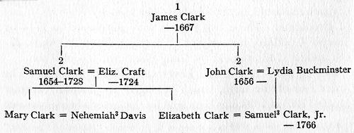
[13] About 1742, not in 1792 as is stated in H. F. Wood's "Historical Sketches," page 352.
[14] See Suffolk Deeds, 75-174. His heirs were twenty-two in number and the list is a helpful one for the genealogist.
[15] Cf R. G. F. Candage: "Jeremy Gridley," in Publications of Brookline Historical Society, No. 2, 1903.
[16] Ten acres from Nathaniel Holland (by him secured from his father-in-law, Joseph[2] White), about sixteen acres of the Grosse allotment from Ruggles, and about seventeen acres of the Alcock allotment; none were recorded.
[17] Proceedings, Brookline Historical Society, 1908.
[18] Cf Suffolk Deeds: Vol. 26, folio 61.
[19] Cf article by Charles H. Stearns in Proceedings of the Brookline Historical Society for 1903.
[20] For this reference I am indebted to Mrs. Charles F. White.
[23] Luther M. Harris: []Descendants of Robert Harris,[] Boston, 1861. This book treats in detail the history of the Harris land in Brookline and renders any further discussion of the family land unnecessary.
[24] This part of Warren Street was known as []Woodward's Lane,[] in 1715, when Clyde Street was laid out.