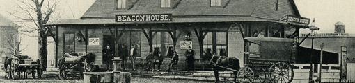
 |
Pearl St.
Looking north on Pearl St. Clockwise:
- 68 Pearl St.
- 76 Pearl St. (speculative)
- 84 Pearl St.
- 81 Pearl St. on the corner as Pearl St. takes a right turn toward Brookline Ave.
- 73 Pearl St., garage
- 65-69 Pearl St., garage
[Source: Brookline Preservation Department]
|
 |
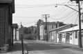
Emerald St.
Looking east on Emerald St. from Pearl St. toward Brookline Ave. before the leveling of the neighborhood in the urban renewal project of The Marsh. From left to right:
- 9 Emerald St., the small house
- 657 Brookline Ave. on the corner
- 660 Brookline Ave.
- 666/670 Brookline Ave.
- Partial view of the auto garage at 676 Brookline Ave.
- A town truck parked at 100 Pearl St., the Brookline Water Dept., a building that still stands
[Source: Brookline Preservation Department]
|
 |
33 Bartlett Crescent
[Source: Joel Shield]
|
 |
9 Emerald St.
657 Brookline Ave. is on the right.
[Source: Brookline Preservation Department]
|
 |
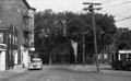
657 Brookline Ave.
On the left is Emerald St. looking west toward Pearl St. On the corner is 657 Brookline Ave. followed by #651 and a partial view of #647.
[Source: Brookline Preservation Department]
|
 |
65 Kent St.
Looking east on lower Kent St. at a shed of the Bay State York Co., a heating and refrigeration company whose main location was across the street at 74 Kent St. Station St. enters at the left.
[Source: Brookline Preservation Department]
|
 |
Quinlan Pharmacy., 1186 Boylston St.
Standing on Hammond St. looking south across Boylston St. at 1186 Boylston St., the Quinlan Pharmacy. On the far left is 615 Hammond St., still standing, with 609 Hammond St. next to the pharmacy. On the right of the pharmacy is 1188 Boylston St.
[Source: Brookline Preservation Department]
|
 |
167 and 163 Washington St.
This photo was taken prior to the leveling of the block for the Hearthstone Plaza and the leveling of the entire area then known as The Marsh. The business of the Brookline Bulk Candy was deemed by the Brookline Redevelopment Authority to be neighborhood-specific and was relocated across the street at 216 Washington St. By contrast, the Ames Supply Co., partially viewed on the left, was not given an option to relocated nearby.
[Source: Brookline Preservation Department]
|
 |
171 Washington St.
The tracks to the D subway line lie immediately to the left. The building anchored the northwest corner of the area then known as The Marsh that would soon be completely leveled in an urban renewal project. Ames Supply Co. was one of thirteen businesses forced out by the Brookline Redevelopment Authority, being deemed not essential to Village Life and therefore not eligible for local relocation on redeveloped land.
[Source: Brookline Preservation Department]
|
 |
202 -222 Washington St.
All buildings still stand.
[Source: Brookline Preservation Department]
|
 |
645/647 Brookline Ave.
This photo was taken prior to the leveling of the entire area then known as The Marsh.
[Source: Brookline Preservation Department]
|
 |
682/684 Brookline Ave.
Looking east. Gulf service station on the corner of Lower Washington St. is on the right. This photo was taken prior to the leveling of the entire area then known as The Marsh.
[Source: Brookline Preservation Department]
|
 |
Emerald St.
9 Emerald St. is on the left, sideview of 657 Brookline Ave. is on the right. This photo was taken prior to the leveling of the entire area then known as The Marsh.
[Source: Brookline Preservation Department]
|
 |
647, 651, 657 Brookline Ave.
Looking from right to left. This photo was taken prior to the leveling of the entire area then known as The Marsh.
[Source: Brookline Preservation Department]
|
 |
65 Pearl St.
This photo was taken prior to the leveling of the entire area then known as The Marsh.
[Source: Brookline Preservation Department]
|
 |
81, 84, 85 Pearl St.
The northeast extension of Pearl St. is viewed looking west several houses in from Brookline Ave. 85 Pearl St. is on the left followed by 81 Pearl St. On the corner and a building of Brookline Oil Co. across the street at 84 Pearl St. This photo was taken prior to the leveling of the entire area then known as The Marsh.
[Source: Brookline Preservation Department]
|
 |
91 Washington St.
Pearl St. looking north to the left.
[Source: Brookline Preservation Department]
|
 |
68 Pearl St.
This photo was taken prior to the leveling of the entire area then known as The Marsh.
[Source: Brookline Preservation Department]
|
 |
21 Pearl St.
Looking south at 21 Pearl St. On the right, where Pearl St. turns left toward Lower Washington St., is the building at 10-14 Pearl St. This photo was taken prior to the leveling of the entire area then known as The Marsh.
[Source: Brookline Preservation Department]
|
 |
68 Pearl St.
On the left is a partial view of a newer brick building at 50 Pearl St. In the middle rear is 68 Pearl St. located on the former northern extension of Pearl St. In the middle foreground are vacant lots where several apartment buildings recently stood. This photo was taken prior to the leveling of the entire area then known as The Marsh.
[Source: Brookline Preservation Department]
|